
According to the internets, Silver Star Mountain is named for the 5 arms of silverish rock (basalt?) that radiate out from the peak and form a very distinct star pattern that can be easily discerned from an aircraft. I doubt this origin story somewhat. First, I flew over the peak in google maps and saw no such pattern. Second, don’t you think a mountain would have a name before there were airplanes? I think I should start a new website where I make up origin stories for different places just to see if I can get my origins fixed into the mindset of the web. All you need is for a few people to read your story when they are doing some quick ‘research’ for their blog or article or thesis and BOOM, your idea is everywhere.
Silver Star Mountain is named for the Silver Star Mining Company which operated a small silver mine at the base of the mountain in the late 1800’s. The original owner, Joseph Stern, was a German settler and named the mine after his family (Stern is Star in German). Like that.
I am not sure why I have never heard of nor hiked this trail before. It is only an hour or so outside of Portland, just North East, and it has perhaps the greatest views of the local Cascade volcanos of any other prominence. Getting there is a bit of a challenge as you have to drive down poorly marked dirt roads for 10 miles or so. But there is a nice, but rustic, bathroom at the state operated trailhead and plenty of parking for all of the intrepid souls that want to slug up that damn mountain. Oh, did I say that out loud?
The road to the trailhead is North up the Washougal river from ….well… Washougal, Washington, just across the Columbia from Rooster Rock. The road is part of a vast array of forest service and lumbering roads that exist through most of the forest in the Pacific Northwest. The mountain itself lies just inside the Gifford Pinchot National Forest, but the trailhead is on State land and requires a Washington Discovery Pass to park. If you are hiking in the summer, bring plenty of water. My partner says she hiked here last year in the early spring and was stopped by deep snow and hail. So don’t do that.
The ‘trail’ is actually a part of old retired logging roads. These are roads that were originally made a hundred years ago and abandoned after all of the trees were gone. In the intervening years, the trees have grown back (mostly) and the road have been narrowed by the collapse of the mountain sides. What remains is in some places a single track trail and in others a fairly wide trail. The other feature of an old logging road is that they tend to be much steeper than a trail would be if it were originally designed for hikers. Trucks, even those from a hundred years ago, can evidently climb mountains pretty darn well.
 |
| Looking Up |

You start out on the Grouse Vista Trail which is just across the road from the Outhouse. The first hundred yards are pleasant dirt packed old road, but then you there is a turn right at a sign posted as “Silver Star”. If you look up you will also see a archway with the inscription “Abandon All Hope Ye Who Enter Here”. Which is a bit confusing since the trail seems to be going straight up.
This part of the trail is wide and steep and covered in the white or gray rock that is prevalent in the area. The rocks range in size from pebbles to head sized with a good number of shoe size floating around. They are loose rock and will shift when you walk on them. The trail is steep enough, and the rocks frequent enough, that I found myself wandering back and forth across the path to find the easiest (and less shear) way forward. This means that instead of doing a straight line on my 3.5 miles to the summit, I was doing a zigzag much of the way. So that is something like an additional sqrt(2) of distance! What a great workout!


You slug your way up this first quarter mile of very steep, rocky, hard to negotiate trail through a pine and fir forest, but never fear, just up ahead is a leveling and…. And… Well, it seems like there is just more rock up here. OK. No problem. You slug you way up the second quarter mile of very steep, rocky, hard to negotiate trail through a pine and fir forest but never fear, just up ahead is a leveling and…. What the Frak? More Rocky Uphill! Deep Breath. Slug Again. And Again. For what on my fitbit says is 2 miles and took us nearly 2 hours. Then we are at a place. I like it when you get to a place that is mentioned in the guide book because then you know where you are on the map and don’t have to worry about the distance distortion generated by you trying to carry you slightly overweight 65 year old self up the rocky road.
 |
| Pyramid Rock |
 |
| Red Brush. Tiger Lilly. Some sort of carrot family thingee. |

 |
| Variable Checkerspot Butterfly |

We are at Pyramid Rock. This is a aptly named piece of basalt that sticks up over our head. Very majestic. We had come out of the trees just before this and had been rewarded for our (continuing) hard work with a wonderful display of late blooming wild flowers. There is a lot of lovely Red (not orange) Paint Brush along with Tiger Lily, Bunch Berry, Daisy, oh, and some I will look up and put the names on the many pictures that we took. Butterflies are also surrounding us. Many Tiger Swallowtails and what I think are painted ladies… but they were rather small for that. I will look them up also. I could look them up and not tell you and then you would think I know everything, but that might make you distrustful of my origin story earlier in this piece and we wouldn’t want that.
 |
| Bunch Berry |
 |
| Bunch Berry with Paintbrush |
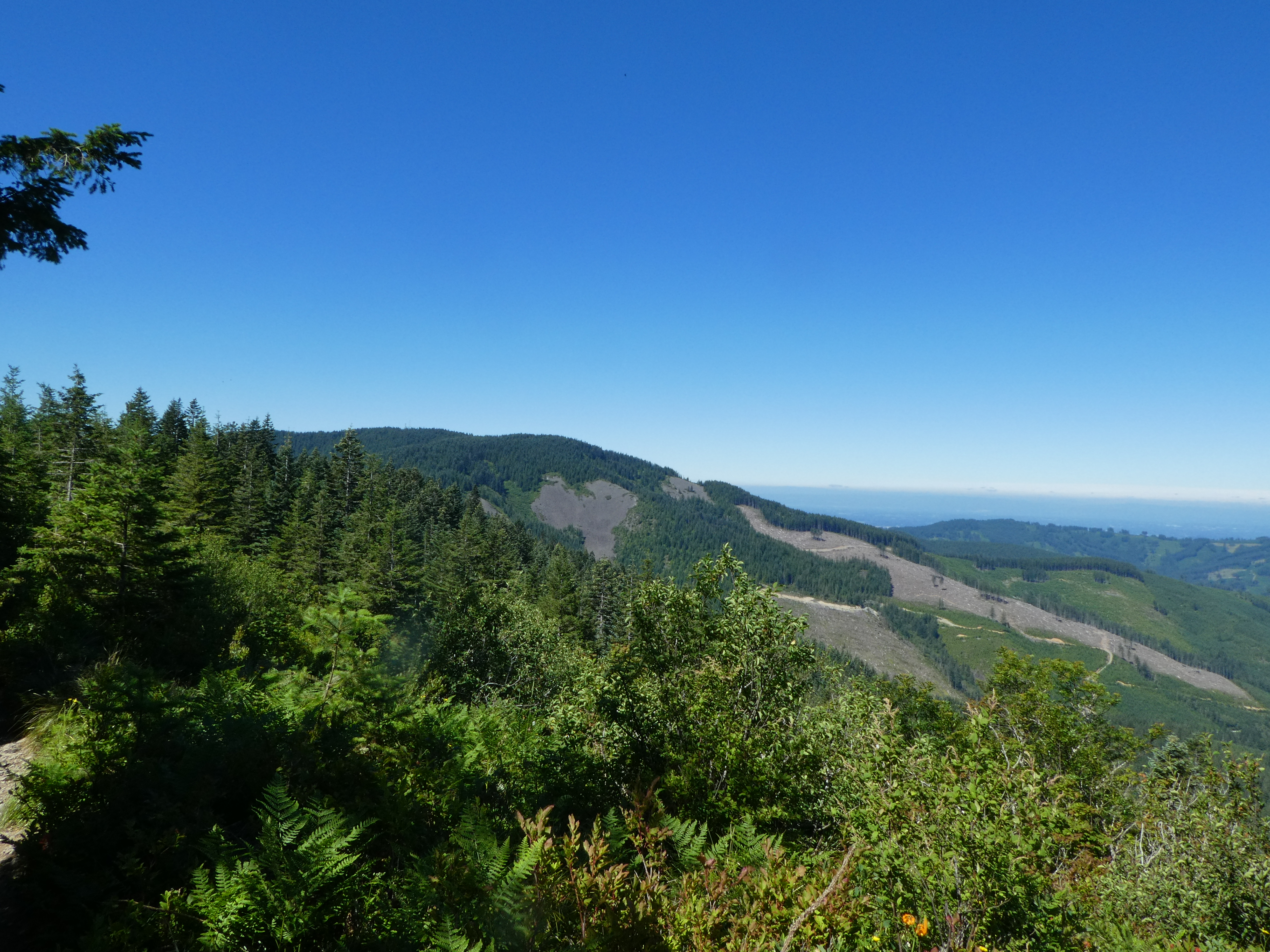 |
| Clear Cut and Skree |
 |
| Tiger Lilly |
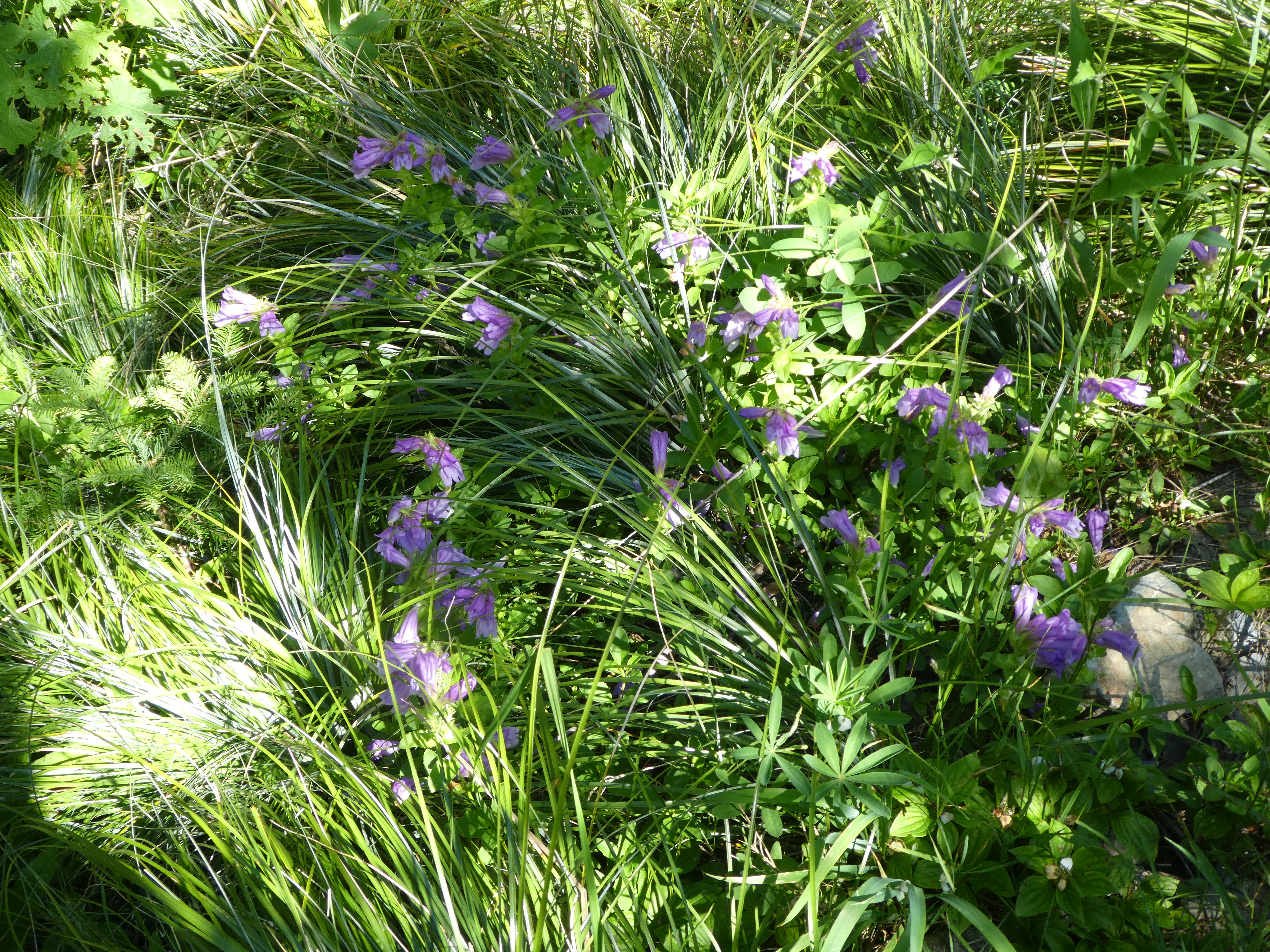 |
| Hare Bell growing amongst Bear Grass |
 |
| More Sneaky Uphill |
 |
| Rose Meadowsweet |


The trail around Pyramid rock is very nice. You get good views of the surrounding clear cut as well as some nice pseudo-level hiking along the scree coming down off of the basalt ledges. Once clear of this rock however, it becomes evident that this was a finger of the mountain we are climbing and now we can put more energy into the actual going up-ness. We have another set of the steep rocky trail. And another. What is up with this thing. My partner later confided to me that she was ready at this point to call it quits and head back to the car, but since I was silently climbing she felt that she had to continue since this hike was, after all, her idea. Why was I silent? No clue.

There are many other people on this hike. Some of which we are passing as they head back down from the summit telling us “The view is worth the work”. No one tells us that we are “almost there”. This is because we aren’t. We are passed by even more people going up the trail and coming from behind us. How come everyone is faster than me? Even the old guys my age are coming up and passing us. I was tempted to walk faster, but decided instead to have a seat and eat some gorp and drink some water and consider.
We had finally made it to a 4 way junction where the trail to ‘Indian Pits’ breaks off. There was a sign there and everything. We sat in the shade amongst a bunch of lovely (what I think were) glacier lilies and had a rest and some water. Paige pulled out here map and guide book. “It is only .4 miles to the summit” she said. I believe the guide book also described this last section as the “steep part”.
 |
| Either Fawn Lily or Avalanche Lily. |

I had mentioned that there are a lot of abandoned logging roads up here. A number of them have crossed our path and confused me as to our location. If you have a good map, they are all on it, but if you have a less good map, some are missing. We had the guide book hand drawing which was OK and the written instructions were also pretty accurate, but still I was amazed that there wasn’t better signage up this well traveled trail. I guess I think that a number of people would make simple errors (“oh, that must be the turn to ‘Indian Pits’, I guess the sign fell down”) that would lead to people getting lost and costing the forest service people money in search and rescue. Much cheaper to put up some nice wooden signs. Not so much. Fortunately for us we could usually tell we were on the right road by the happy smiling people coming back down the trail toward us. Why are the people coming down hill so happy and smiling and talkative and the ones going up somewhat grouchy and silent? Is it the joy that the coming down people have at having seen the splendor of the view that awaits us at the top? Or is there some moral superiority gained by those who have already completed the climb that eludes those of us still in the slugging upward stage? I long for enlightenment.
And I didn’t have to long long.
We passed a group of perhaps 12 women hiking together with what I presume was a guide. I think she was a guide because she gave us very exact and unasked for directions on how to get to the summit: “Stay straight on this trial for a bit. Get to the saddle and enjoy the vistas, then continue on to your left to the summit”.
All righty then.
One last minor up and we are at the saddle. We can tell because there is suddenly no more up ahead of us. Just blue sky and what appears to be the edge of a cliff. AND OH, THE VIEWS.
Stunning.


We have a very clear day, Blue Sky forever. Down below us is a gorgeous valley lined with basalt scree from the circling cliffs. Pine tree green down the valley, a little hiking trail going across the scree. I love the looks of these basalt rock slides. They give the mountains a sculpted look and provide borders for the encroaching forest. Above many of the slides are the mother basalt cliff faces. In the distance we can see the snow bound peaks of 5 volcanos. Starting to the left we have St Helens (which erupted in the 80s), Rainier, Adams, Hood, and Jefferson. Hood and Jefferson are in Oregon on the other side of the Columbia. Rainier is way north up by Seattle. As a fun point of interest, and perhaps to suggest that you rethink your move to the Seattle area, let me list these main volcanos and their last known eruption date:
| Mountain | Last Eruption | Comment |
|---|---|---|
| St Helens | 2008 | Not the Big One |
| Rainier | 1894 | |
| Adams | 950 | |
| Mt. Hood | 1866 | |
| Jefferson | 950 AD | Not to be confused with Adams in 950 |
| Silver Star Mountain | Miocene, which was a long time ago | Yes, we are sitting on a Volcano |
(yes, that was also an experiment with Blogger Tables)


 |
| Look at that Scree !! |
 |
| Sturgeon Rock |
 |
| Looking back at Pyramid |

And once you get you fill of the sights in the distance, switch your focus to the surrounding hillside. Flowers everywhere!! We have a number of new ones, Aster, a new all yellow daisy, and more found in the pictures below (note to self: Put pictures in below).
 |
| Fleabane? |
 |
| Common Woolly Sunflower |

 |
| Flox |
 |
| See the hummingbird? |
 |
| Subalpine mariposa lily |
 |
| Bistort |
We ate lunch on the lower peak to the right because the main peak was a little crowded. This gave us a great place to sit and some good pictures of the actual peak with St. Helens and Rainier in the background (of the local volcanos, did you know that Rainier is rainer?)
I know that on the way up I complained a lot about all of the rocks and the unforgiving upness. But I must admit that here on the top there really is a view to justify the slogging. Not sure why they put all of the good views so far up in the mountains, but there you have it.
As we repack our packs for the trip back down we have somewhat mixed feelings. On the one side, we are still tired from the climb, on the other side, it is down. Down will at least exercise different muscles. We each have both of our trekking poles deployed and we start our way back down the mountain by reciting our new mantra, “This is a No Injury Summer”. We can have aches and pains and slight strains that one may get from good healthy adventuring, but no major injuries. Nothing like a fall and a strike to the head requiring a trip to the ER. No sprained ankles or dislocated shoulders. Also, no age related joint replacements or other surgeries. This is a summer of good healthy adventure only. So slow and steady back to the car does it.
And it was slow. Going down the trail you hit a phenomena that was not present on the way up. Probably on account of gravity and stuff. When you are walking down, and you slightly disturb a rock, say by glancing it with the bottom of your somewhat tired foot in passing, the rock will roll down the hill at approximately the same velocity as your moving foot. This means that you have a rolling rock tracking your foot and you have to take action to avoid it. I almost went down a couple of times as did Paige. A little over half way down I realized that my body was beginning to suffer from a Cascade failure. That is, many small events were causing pains that were cascading up to larger problems as opposed to Everything Failing on account of coming down from the Cascades. E.g. my right knee was a little sore on the step down, so I was putting more stress on my right trekking pole are to help out. My right elbow suddenly let me know that this was no longer appropriate with a sharp strike of pain. Tennis elbow? I shifted over to using my left arm instead, but this almost immediately set off pain in my previously injured left wrist. Dangit. I went a little more slowly and tried to use my legs more. Luckily my right knee seems to have warmed up and had stopped aching.
The engineering wonder, which is my left knee (which has an all metal joint as of one year ago) was doing terrific!! It doesn’t have knee pain (cause, no knee pain receptors) and it is very strong (cause lots of serious PT work) and I just relied a lot on it going down the hill. But I did have the problem that I had to count all of those terrible uphill steep rocky areas in reverse. Come on, Jon, just 10 more of these Mother Frackers, Down and Down we went. Finally Paige asked me how I was doing and I admitted that I was worried about getting to the car. I though we still had at least 2 more major downs to do and I couldn’t completely avoid using my arms with the poles. She suggested that we sit down and rest for 10 minutes. Have some food and water. Let the lactic acid recede from our major muscles a bit. It was that last piece of science that convinced me. One should not argue with science. So we sat.
When we were finished sitting we took off again, went 50 feet, and there was the crossroads sign. Oh My, I could see the car from here. We don’t have 2 more downs at all, we are pretty much there. I believe I issued an exclamation of relief.
OK OK. Yes, there were LOTS of people going up and down that hill that appeared to be having no problem. Talking and laughing and wearing sneakers and just carrying a bottle of water in their hands. But they were like 20 years old. Or at least no more that 40 years old. Big deal. I have a nicer car.
 |
| Western Columbine |
For Plant Identification on this blog, I was using https://identify.plantnet.org/. It has a online service where you drop a picture and it identifies it. Seemed to work pretty well.
 |
| Why is my pack always crooked? |
[NOTE: The Editor has asked the Author to clarify the facts surrounding his partners preparedness. In truth, the Author's Partner had excellent maps and good directions from a guidebook. She was always aware of where they were and how far to the next cross trail. She made these maps and directions available to the Author but he chose not to consult them. Therefore any anxiousness on behalf of the author over his location was his own damn fault]
No comments:
Post a Comment