Driving up the Washington coast from Oregon is like setting out through a post apocalyptic landscape. Only in this apocalypse, the 4 riders didn't come for man, they came for the trees. The trees everywhere have been cut down and a mass of severed limbs, decaying trunks, and general slash have been left behind hither and yon littering both sides of the roadway.
Most of this destruction has happened decades ago but some of it is still fresh. Most of it has no new planting and the wasted landscape is left, perhaps for SciFi channel film crews coming down from Vancouver to use on a set of some popular series.
There are a lot of trees and a lot of logging in Oregon also, but the scale of the thing here seems quite different. We wonder if Oregon has some laws or general practices that make the horror a little less apparent. Like a "You can't kill every single tree within 100 feet of a road where voting citizens drive" law.
Of course, there could be a similar law in place here in Washington and we are just driving along a stretch of the road that is not that often reached by non-logging families. We are traveling to the Olympic National forest, on the Olympic Peninsula, and we have come up by way of Astoria, Oregon. Most people coming this was, either from Portland or the much larger Seattle area, would come in from the East and then gone up the East side of the Peninsula, over by Hood Canal. They would not have come up the Pacific coastline from the mouth of the Columbia. There isn't much coastal access over there and not much to see.... Except for slash.
Want some good photos? I didn't take any as we were driving by. However.... look here.
I just told my partner that we need a day trip out to photograph some Slash Heaps. Not sure she is very enthusiastic about that particular endeavor.
I did allude to the 'logging' families. These are the people that make their livings from the 'harvesting of forest product'. This doesn't just mean the people that cut down trees, the entire area is (or was) supported by this endevour. The stores and the farms and the schools and townships all depended on the money coming in from the sale of timber, which was probably used to build Portland and Seattle (and California). But most of that money didn't stay in this area. Most of it went to the land barrons who were working the system in Washington DC and getting the rights to cut down the trees without actualy paying for the land or what happened to the land in the aftermath. Because of that there are many depressed or even deserted old lumber communities. As you drive you see the many little places that someone has bought a few acres by the road on which sits a Mobile home with a few hand done room additions. Things added perhaps 20 years ago. A few non-working cars or trucks in the yard. Lots of trash and mess around. Not a place that a recent college graduate would look back on and think foundly as 'home'. God that was cold.
There are other undustries here, of course. Just not as obvious. There was qute a few Cranberry bogs (with the Oceanspray sign on the fields) and lots of people selling firewood for local camping. As you get closer to the Olmpic National Forest you see a lot more tourism (camp grounds) and fishing. Lots of big trailered boats coming out here to go fishing.
Once you get up to about the Quinalt area you are into a place where the forests are a little more, not protected, managed. They are managed by people (perhaps Bureau of Land Management) that can afford (or have the power) to constrain the harvesting to something that can more easily be referred to as a 'system'.
When you think about it, Timber is a difficult 'crop' to 'manage'. How many years do you wait before you harvest your trees? What methods do you use to harvest? What other resources are you trying to protect when you do this harvesting? What money should be set aside to restore the harvested area? Who is going to set this money aside? Who is responsible for unforeseen results of the harvesting? It is a bit hard for lone person to answer questions like this.
Lets say that you own one hundred acres of timber. It is worth (say) $10K an acre. The timber on your lot has never been cut and all of the trees are over 100 years old. Not Old Growth, but good big trees. What do you do? Do you cut them all down and take the $1,000,000 (minus your cost for labor?). Then what? If you replant you will not be able to make that kind of money again for another 100 years. How long do you have to wait before the timber is mature enough to justify a harvest? 1 year? No.... 10 years? Not really. 50 years? Yes, you can probably make money at 50 years. The Trees will not be huge but they will be big enough for 2x4's and fire wood. But that means that you can only harvest these 100 acres once (or perhaps twice) in your lifetime. Hardly a sustainable business It is also not a very healthy forest. It will not be sustaining many other plants and animals. It won't have any real recreational value to humans. For 10 or 20 years it will pretty much be an eye sore, a scar on the land. It will also be contributing to local erosion and flooding, causing problems (literally) down stream. Not to mention unintended (though predictable) secondary effects.
Lets take some examples from a forest local to the Portland Area. A forest that many Portland school kids have driven through on the way to the beach and many have even gone into on school field trips and planted Doug Fir Seedlings to repopulate the forest (the timber industry loves that).
In the early 1900s the Tillamook forest was being harvested. At the time they were using the "Cut everything down" method. The lumber jacks would go up to a tree and chop two small holes in either side of the tree at about chest height. This would let them insert boards on either side that a man could stand on. Now two men on either side of the tree could operate a hand pulled cross-cut saw and cut the tree down at the 5 or 6 foot line. This was high enough to be above all of those pesky tree roots and so give a more useful log. It left a 6 foot stump sticking up with the two holes. These stumps with holes are still seen in pretty much every forest in Oregon and Washington. From the tops of the local hills, Iron rope lines have been rigged and the timbers are swayed onto these lines and then pulled by steam donkey (a steam engine mounted on wood runners used for pulling and lifting) down the mountain where the logs could be hauled out by steam trains on specially laid tracks. If you climb one of my favorite hikes in Tillamook (Elk Creek Trail), it follows an old lumber road and all along the creek (for 4 miles) you can find the stretch of one inch thick iron ropes that was abandoned there. The rope winds up the river along the ground, in the river, up the slope, sometimes buried, sometimes not. Be careful where you walk if you leave the trail toward the water, you might get empaled.
Hauling the logs down the mountain into a big stack with a Steam Donkey can run into a lot of friction between logs. The friction causes heat and heat causes fire. At one time the logs in Gails Creek area caught fire and a huge part of the Tillamook forest went up in flames. In the Tillamook area, something of this nature (though by different technologies) seemed to happen once every 20 years or so, causing a few "Tillamook Burns". There is a logging museum along the Wilson river, built by the logging companies, that tells the tales of the burns and how important good logging practices are to preventing such economic tragedies.
Of course, there is also what happens if you don't start a fire. Then you have just created a huge denuded mountain. Where once there was a thriving ecosystem, now there is just a hill of mud.
To service the Tillamook area, a train line was built from Banks to the coast. This line paid for itself because the trees around it were cut and hauled out by the train line. But there were many very beautiful bridges and lots of tunnels to build the line. The tracks went down the Salmonberry river, and for many years (and to this day) the only way to see the beautiful Salmonberry river valley was to travel those tracks. Portlanders used to ride the train to Rockaway and BayOcean for a weekend getaway to the shore. Then, in around 2006, some over foresting led to flooding and land slides that tore out the tracks in many places. For a few years the tracks sat unused waiting for repair, but they were eventually just abandoned as too expensive to maintain. And there they sit. Tracks, bridges, tunnels, many timber cars or auxillary vehicles, just left to decay in the forest. Will the the people that caused the flooding have to pay for cleanup? Evidently not.
The problem is that it is very hard for mere humans to have either the wherewithal or the foresight to manage a crop that comes to maturity in the centuries time frame. We need a system where individual trees are harvested, not entire hillsides. And this sort of thing cannot be an industry for a town of people. It is more like something for a select few. Of Course, this is going to make wood really expensive. Time to start doing more building with Rock and Dirt.
But I Digress.
We were driving to visit the beach....
 |
| You can't get to the beach around here without going down a cliff |
 |
| Kalaloch Lodge. Our room is the top right. |
We are traveling up the coastline to spend a few days touring the Olympic National Park. We have a room at one of the many NP historic lodges that are sprinkled around the perimeter of the park. We are staying in Kalaloch lodge, which is a small lodge with a large set of individual cabins on the 40 foot high bluff of Kalaloch Creek where it runs into the Pacific. We had had some problems getting accommodations at the park (lesson: Plan further ahead) so we ended up getting their last room, which was also their largest and most expensive room. However, the room was pretty nice and it was in the lodge on the second floor with a beautiful view of the coast and our own fire place.
The Washington coast is similar to the Oregon coast only it has more scattered logs and fewer people. Both are probably caused by the Washington coast being more difficult to access. We went for a little pre-dinner walk on the beach right below the lodge. There was a sand and log stair access built over amongst the cabins. Huge 4 foot diameter logs had been raised up from the sand and stood like giant fence posts along the way making a sort of enclosed stairwell protected from the aggression of the Pacific Ocean storms.
The length of the shoreline is layered with textures. First you cross over the layer of drift wood and logs. Much of this is decades (or perhaps centuries) old white logs. From 1 to 6 feet in diameter. Stacked willy nilly and dangerous to cross except in places where some sort of path has been made for us older humans, During an extremely high tide, especially one with some sort of storm surge, these logs would be floating and moving and then they would be death to cross. Next is a 10 to 20 foot layer of rounded river (ocean?) stones. These are large for round stones, perhaps on average of 5 inches in diameter of flat ovals. Then comes the sand. The sand for the most part is white and slightly coarse.
Large stretches of the PNW coastline are just shear rocky cliffs where the ancient lava flow basalt stopped its march to the sea. Other parts (usually close to a river or creek) have arbitrarily long sloping beaches where the sand may run a few hundred hards from stone to sea at low tide. Of course, most of the trail access for humans leads down to the sandy parts.
I enjoy walking on the beach. I think my brain likes to attempt pattern matching on the waves. Trying to predict which ones are going to come way up the beach and force you to take a couple of laughing steps up hill to avoid wet feet. It is also a rare beach walk that doesn't find some unique and curious oddity, either natural or manmade, just lying there awaiting discovery. If you get tired of walking along the water, you can walk over closer to the stones and drift logs. Curious and beautiful shapes and sizes can always be found there. I used to think that the logs along the beach were not natural but were a result of constant logging. On some beaches all of the logs have a clean cut end. But most of the logs up here are whole and I am thinking they either fell from the cliffs (we saw a few like that) or came cascading down the rivers and creeks during big flood storms (the Hoh river was certainly filled with snags).
We let ourselves sleep in the next morning, but we were still out the door pretty early ready for adventure. Today we have decided to drive up North and go hiking on a beach that promises a fine set of rocky islands and fingers right off the coast. The beaches on the Olympic Pennisula Pacific coast must have been named by someone with significant learning and creative bent. Down by our lodge, for instance, the beaches are named 1,2,3, and 5. Not sure what happened to 4. Where we are going, the beaches are named First, Second, and Third.
We are going to do a 1 mile hike out to Second Beach. As we drive North on 101 we see signs indicating things that we need to visit later during our trip (probably tomorrow). Including Big Cedar Tree and Hoh River Hiking Trail. The landscape continues to be populated with big trees and clear cut with your occasional run down mobile home surrounded by abandoned vehicles. I am sure there are some really nice homes around here someplace, but you can't see those from the highway. They are probably overlooking the shore cliffs.
The only town that we pass through is the rather quaint village of Forks. This is the town that was made famous by the Twilight vampire books and movies. There are a numer of vampire themed shops and signs and such. The logging museum and nicely preserved logging steam engine look much more interesting. You would be surprised how many old logging steam engines end up sitting around in these towns. Once the logging dried up (and new hauling technologies emerged) there wasn't much use for the huge machines. The logging engines are designed with pistons that face up and down and provide geared power to multiple wheels. This gives them a lot of towing power-friction. It also makes them very slow. So very good for hauling logs off the mountain. Not so good for hauling freight on the main lines.
There is a shopping complex on the South side of town. It consists of a common (in the PNW) semi-independent grocery, an Ace hardware store, and an outfitters. These three stores are in the same big building and are all open to each other inside. You can take the same grocery cart through them and pay for any item at any checkout. The Outfitter had the most marvelous selection of small ropes and lines that I have ever seen. I got myself 100 feet of some very fine line, let me tell you. This places goes on Jon's list of stores to visit again. (no, I am not kidding)
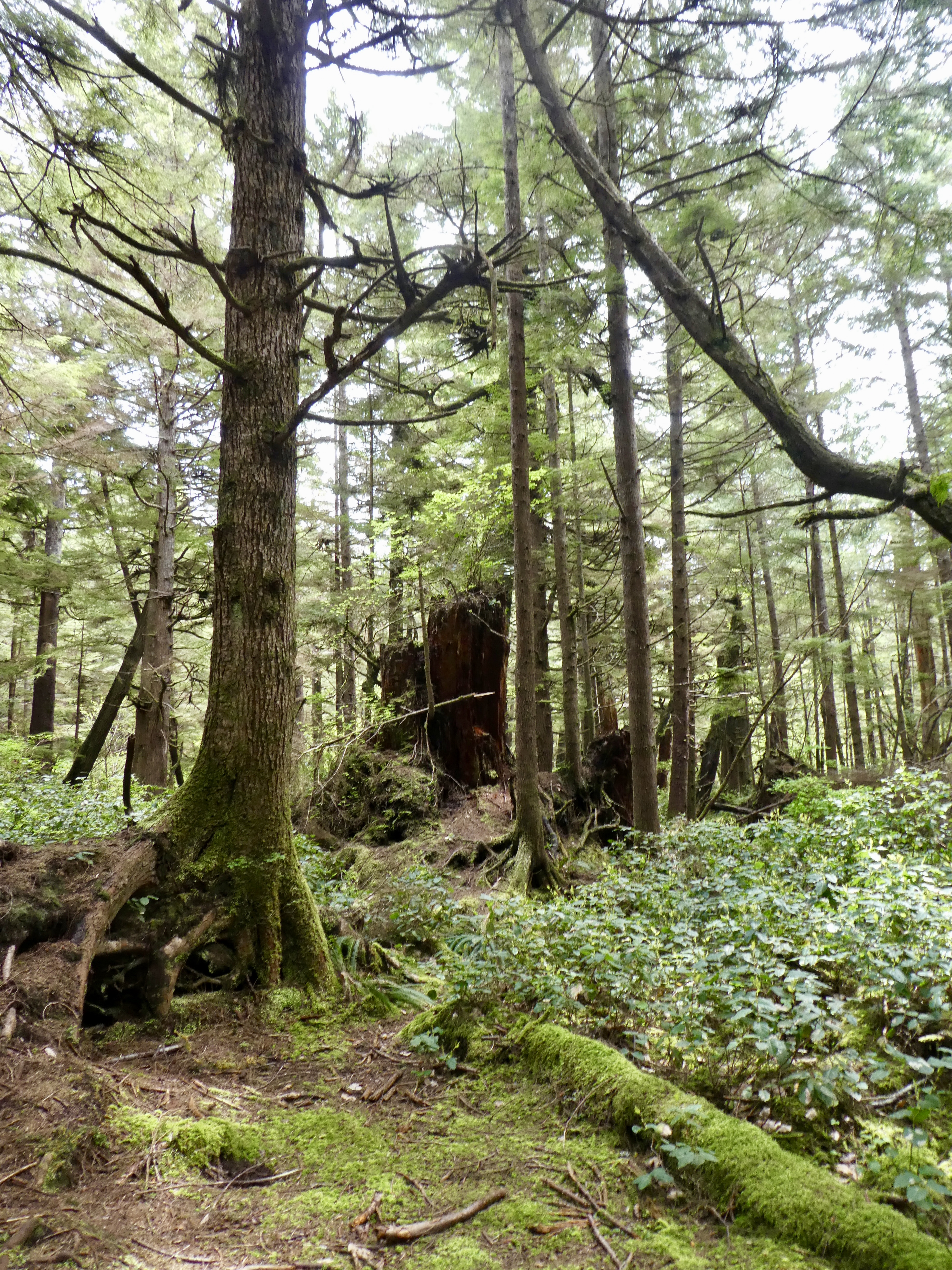
 |
| Lots of Nurse Trees here |


Just past Forks, we take a left and drive the 10 miles to the ocean. Lots of cars in the parking lot (I guess we aren't as early as I thought) but we find a place and shoulder our packs and head off to Second Beach. The walk through the woods is really lovely. My oh My the trees are big. Lots of "Nurse Logs". These are ancient and dead old stumps or fallen logs that new trees grow right out of. We hike up over a little rise and then a steep set of plank faced steps down to the beach. There is a little trail through the heap of old bleached logs and then we are at Second Beach. Quite a few people there right at the trail, but once we had walked half a mile we pretty much had the shoreline to ourselves. The guide book says that during the summer there are campers every 50 feet along the shore. That would be interesting to see. I think it would be hard to find enough safe "above High Tide" camp sites for that. We did see 2 groups camping, but they were half a mile apart. We hiked out to the water (it was just at low tide) and then south until we were blocked by the steep headland coming out the ocean. Everywhere along the way, the land was steep wooded cliffs going up 100 feet. It would have been very hard to climb out anywhere except at the trail head.
Just off short, the ocean is speckled with high rising rocks and islands. From the right POV you can see that they were formed by a single long arm of rock extending out into the ocean that was then eroded by time and storm into individual islands, rising 50 feet up from the ocean, the larger ones with a forest of trees on top. I wonder if anyone has ever been up into those trees.......
We ate our lunch sitting on a big log at the South end of the beach just near where a fresh water stream comes cascading down from the heights to run down the beach the sea. Though there were a few foot prints in the sand from someone before us, we didn't see or hear anyone during the time we ate lunch. Just the waves.


On our way home I took note of an area that was being managed as part of the "Washington Experimental Forestry" section. As we drove there were quarter mile sections that were well forested (trees maybe 30 years old) and then sections that were freshly clear cut (green branches were evident in the slash heaps). It was very evident that this was at least the second harvest of this area as there were two sets of stumps. The very old stumps, that were 10 feet in diameter, and the recent ones, that were 1 foot in diameter. I don't know what they do when the stumps are so close together that that can't get new trees to grow up through them. That will probably be in 2 more harvests. I guess I will check back and let you know.


