
Border Crossing
We are traveling through BC Canada from Portland Oregon on our way to Jasper National Park (which is sort of on the border of British Columbia and Alberta in the Canadian Rockies). We decided to spend our night of traveling in Kamloops which is a pretty substantial town a little over halfway to Jasper. We are traveling on June 19th, Juneteenth, which also happens to be our wedding anniversary.
The weather in the PNW has been warm (not hot) and dry for almost a month. Our front yard has started to go dormant. It is very early in the season for that to happen. As things go, the weather rolled in just in time for our vacation and we had hard rain and hail before we left and then pretty much constant drizzle all the way up to the border crossing (and beyond). We crossed in a little town just east of Vancouver with about a 30 minute wait at the crossing (6 or 7 vehicles in front of us). We intentionally packed to make the crossing easier. At least we thought we did. No fresh fruits or vegetables or meat. No weapons. We made sure and got Canada legal bear spray. The crossing guard asks Paige, who is driving, “Are you bringing anything with you other than your clothes”.
We have a travel trailer and a car full of stuff. How can the answer be no? Of course, he was asking what I would call a stupid question. He can see that we are inside a car and we are obviously bringing it with us.
Paige says we have some food items. He then says “So, you are bringing in things”. And goes through a list of questions lisk “Do you have any Guns? Ammo? Drugs? Alcohol? (we have 2 beers).”
He asks us to roll down our rear seating window so he can see that no one else is in the car. I don't think he even glanced at the 13 foot trailer we were pulling. Maybe since it isn't metric he isn't allowed to legally see it.
And then he says “Have a nice trip” and off we go.
Right away we get into some trouble with the speed limit. It ways 50. I remind Paige that this reading is in Kilometers per hour. Shit. She forgot. How fast is that? I look over at her speedometer to make sure I am right and let her know that that KPH is listed in a little wheel in the speedometer opposite of the MPH numbers. How many people know this? I mean, the KPH numbers are very small. Not all that useful for me since I can’t really read them when I am driving.
Canadian Grocery
I like going into retail stores in different countries. There are always these little differences in products and presentations. In Canada (well, in BC, since I think the different provinces have different laws regarding alcohol and such) we went into a big chain grocery to get our food for the trip. That layout and such isn’t so different from a grocery in Oregon. Here are the things I found different:
Different plants in the produce aisle. Not necessarily because of location, since some of these must have come from out of country. My friend Marty says it is from the different mix of peoples and the vegetables that they expect. Saw really HUGE carrots. I mean, carrots the size of loafs of bread. Could not find any yellow squash.
Processed meats were very different. They had some very cheap canned tuna. They did not have any pre-cooked sausage except for hotdogs. They had a LOT of different hotdogs available. We were looking for something like Chicken and Apple Aidels. We did find some turkey sausage but it was fresh (not cooked). Not saying this is a good thing or a bad thing, just different.
 |
| This was over near the produce aisle |
I asked after beer and was told that they only sold BC sourced wine and cider. For beer I had to go across the street to the liquor store. Not sure why only wine and cider. Not sure if the BC sourced was by law or just because.
It was also strange which things were using metric and which were using pounds. I think apples were by the pound, but milk was by the liter. Other fruits were by the gram. I was surprised to see that some things were sold by the pound (and I may be wrong about that being apples).
And, of course, everything was in Canadian dollars which just made it harder to figure out if something was expensive or not. At the time of this writing $1.32 Canadian is $1.00 US. Wow. So that means 75% discount on the Canadian Dollar price to get the American Price. That is better than I thought.
On checkout, we wanted to get some Canadian Dollars as cash back, but we couldn’t do that with our debit cards. I guess that just isn’t something that is done. Need to go to a cash machine at a bank. I did get some great BC cider.
Kamloops to Jasper –
They store a lot of space in Canada. It just seems to go on and on. In this territory, it is a lot like the high desert of Oregon. Small sort of stunted pine trees (in Oregon, they are lodgepole pines, not sure what they are called here) and a lot of exposed rock. I guess the big difference is the general construction of the land. In Oregon is was all about volcanoes and lava flows, here it is all about receding glaciers. And rivers. Lots of rivers and streams everywhere and all of them with big beds of large rounded rocks. The rivers we were seeing were fast moving big water things but still relatively flat (not a lot of rapids or big rocks in the river). Just a flat expanse of fast moving water.
The weather here has been unseasonably cold. Here we are 2 days before the official start of summer and there are warnings on many of the roads going up to the mountains about snow conditions. Our friends coming down from the north east of Jasper sent us some pictures from out of their windshield of the road they were driving. Snow on the road and slippery conditions and big trucks struggling to make it up the slushy grades. Not fun.
The roads, in general, are a bit of a challenge for people that are just learning to deal with their new Scamp camper. Though the little thing is easy to tow, it does require that you pay closer attention to your speed. Sudden braking at high speeds is not a good thing and could cause you to lose control of your vehicle We have a braking system in the trailer that is inertial controlled and seems to work pretty great. Coming over the last set of mountains into Kamloops we hit a stretch on the mountain pass where we drove into the clouds and suddenly the visibility was very limited. In a time like that it is very easy to be going faster than you can actually see and so you don’t have time to stop if something is going bad in front of you. People were slowing down pretty good but there is always someone in a rush that comes speeding up behind you through the fog.
I guess the main difference when towing a trailer is that you can’t see behind you very well. I still keep glancing in my rearview and all I can see is the front of the trailer. We do have a little rear facing camera with a screen that sticks to our windshield. It shows us what is going on out back but the lens is a little funny and mainly designed for backing up. You can see someone that is hugging your bumper but no real sense of what is behind you at a distance. I don’t like it much when the great big 2 or 3 trailer long trucks comes past me.
I was keeping my speed to 60 (that is 100 Canadian) even when the limit was a bit faster. 60 felt good and safe and not like I was slowing everyone else down too much.

When we woke from a nice night in a hotel in Kamloops the latest news said that the road to our campground in Jasper (we are staying in Wabasso) was ‘not recommended for travel’ due to snow and some landslides and flooding. I guess they had a LOT of rain and snow in the last 24 hours. Some local communities had been evacuated because of the threat of flooding and they were talking about getting like 2 feet of snow up in mid to high elevations. 5 or 6 inches down on the valley floor. (well, the valley floor up there in the Canadian Rockies).
Our friends were going to drive on to the town of Jasper and if things stayed strange we would meet them there and spend the night their until the road opened.
What beautiful country we are driving through. The very rocky mountains climb steeply to either side of a wide valley. I guess this is what it looks like if a glacier carves it instead of a river. There are rivers running through the center, but they don’t have that sort of gorge like feel you get in other places, they are just meandering swiftly down the valley. We have been seeing highway signs that warn us of Bighorn Sheep and Moose crossings but we didn’t actually see any of the animals. I did see a lot of nice wild flowers growing along the side of the road. A big bunch of Tiger Lillies. I wish I could have stopped to admire them.

A text from our friends say that the road to Wabasso is open but has a few spots that are constricted by mudslides. So we head up the pass into the mountains toward the town of Jasper. This is a wonderful road with great views. Big glacier carved lakes surrounded by steep mountains and large wonderfully blue-green rivers flowing large and full right there outside the window. We round a corner and ahead are several separate ranges of snow covered rocky peaks. Some look like they were the model for the paramount rock in the movies. Big, Sharp, sort of Triangular, and spotty covered with snow and ice. Beautiful.
We are also passing by a lot of vacation sort of businesses. A largish looking resort that was dedicated to “Helicopter skiing”. Lots of places for RV camping. Lots of places advertising backcountry jeep safari or river rafting trips. The town of Jasper (where we stopped for gas) was overflowing with RVs (many of them advertising themselves as rentals).
I would also note here that we had really excellent cell phone coverage in Canada. Pretty much everywhere we went (except up wilderness passes) we had connectivity.
 |
| a wee snowman |

We got to our campsite around 6:00. There is 3 to 5 inches of snow on the ground, though all of the streets are clear as well as are most of the parking pads. We had no problem backing in our little camper even though the approach to the site was a little awkward and down hill. Good thing I brought a long heavy-duty extension cord because the power connectors are very strangely placed up near the front of the parking pad, as opposed to further back where a camper electrical would actually end up being (in parks in Oregon, the power is at the back of the pad near the little barrier that stop you from rolling off the pad).
We had dinner with our friends and then went for a nice walk down the river. What a big fast moving and gorgeous river. No kayaking on that puppy for us, however. A little too fast and cold, I am thinking. (oh, and we didn’t bring the boats). We saw lots of rafts on the river during the week and it look pretty safe in a large raft.
Trail of 5 lakes
We are staying in the D-loop of the Wabasso campground of Jasper National Park. Just across the Athabasca river from us (though you have to go around the long way to get there) is the trailhead for the Trail of 5 lakes. This is a relatively easy and family accessible hike with a big parking lot that was pretty much full when we got there. So, you aren’t going to feel lonely and out in the wilderness while you do this hike. But even so, there are some lovely views and some cool geography to be viewing in the 4 miles of hiking. This side of the valley has been glacially carved with a number of steepish ridges and valleys. The valleys are filled with marsh or creek or (at the furthest reach) a string of beautiful blue-green little lakes. The lakes are named presumably in the order they were originally found First Lake, Second Lake, Third Lake, Fourth Lake and Fifth Lake. It sounds a lot more romantic in French. It is a lollipop hiking trail with a straight walk out and then a loop around the lakes. We did the loop anti-clockwise which put us at 5th lake first, where we ate our lunch. The lakes are all round with large but smooth stone floors. They don’t appear to be very deep, though there might be a little of that ‘under the retreating glacier’ canyon going on in the center of a couple of them. Note the dark water in the photographs. Fifth lake is the highest of them and a little (seasonal) creek runs from lake to lake keeping them all filled. I note in a google lake shot that one of the lakes is pretty much dry once the streams stop running (from snow melt). I don’t think this area is glacial fed any longer.
 |
| Stick part of lollipop trail |


We saw some fish in the lakes. How do fish get into lakes like this. They sure didn’t evolve here. I guess they could have same up the streams during some earlier age when there were streams to swim up. Or someone put them here. Perhaps the indigenous peoples made it a habit to stock lakes for their later use? How can one research this? (Google. Try Google). OK OK. Google says that if the fish didn’t get there naturally then it was probably put there by the park service or some sports fisherman organization. Drat.

Town of Jasper

 |
| Old Steam Locomotive on display in Jasper |
Skytram ride to The Whistlers

We took an mid-morning ‘flight’ on the Gondola up the mountain to The Whistlers. This is not to be confused with Whistlers, which is a famous ski mountain. This is The Whistlers, which is named after the sound the Marmot that live on the top in the rocks make. Our plan was to spend 3 hours up on top and do the hike up to the very summit (like a 1 mile each way) and get the ultimate views. Afterwards we were going to have lunch in the restaurant up there.

The trip up is like 7 minutes. Most of that we were in dense cloud and couldn’t even see the trees right below us. There is an operator on the lift with you. I think they are just sort of safety and ‘make sure no one panics’ sort of guys. They keep up a constant banter about what you could see if there wasn’t so much cloud and warn you about the slight swing when you go over the support post at mid-ride. This is the kind of gondola that has 2 cars (one going up and one going down at the same time) each car holds maybe 15 people. The rides were like $50 (Canadian) each. So not cheap. One the way up , our operator told us that there was still deep snow on the trail leading up to the summit from the storm that had hit on Monday. They were not recommending that anyone try to get to the summit. He also told us that once we stepped off of the boardwalk around the Gondola anchor building we would be in Park Canada property and employees of the gondola franchise would not be allowed to help us in anyway. If we got in any trouble at all and needed support, they would have to call the Park Canada rangers and get them to send help. I was envisioning me stepping off the boardwalk to lay down in the snow and make a snow angel. “Help me, help me. I can’t get up!”. “I am sorry sir, we have called the Park Canada Rangers and they have made a reservation on the 3:34 upward bound Gondola Flight. Just hang in there”.
 |
| can't see the chalet |
As it turns out, lots of people were taking the risk of stepping off of the boardwalk and trying their hand hiking up to the summit through the slush and snow and ice. It was very slippery and most of these people seemed to be from foreign countries where I suspect snow was unusual. They were not dressed warm or dry and wore sneakers and were urging their kids to pick up the pace. I think most were turning around after 100 yards or so, which was a fine decision. You get some adventure but don’t get too wet. We had our snow spikes and trekking poles and rain gear so we thought we could do a little better.
In normal, none snow summer, times, there is a well marked (and signed) trail (perhaps 2 trails) that go up the mountain to the summit. At this time, you can’t see those trails because they are covered in something close to a foot of snow. You can see a few trail signs sticking up from the snow, usually close to a bench (presumably to rest from climbing). People going up the hill have been taking whatever path that they think will be easiest to walk and so have been aiming at things like occasional clear rocky spots. I am sure that most of these spots have signs near them that are now under snow that say things like “Fragile plants and rocks, Please Stay Off” (perhaps repeated in French). We put on our snow cleats and head up the stomped on snow. Ahead of us, up the hill, are a few dozen people. They are strung out all the way to the misty summit in a scene that reminds me of ones I have seen of hundreds of climbers lined up on the ascent of Everest. Is there a string of bodies frozen in the snow, I wonder? I mean, who knows how long it takes Parks Canada to get up here on a busy day. We have already been told that if we miss our reserved descent gondola time we could be stuck up here until the end of the day.

But one we go. The going is actually pretty hard. We are at like 11,000 feet, a little hard to breath, the snow is deep enough that if you are not careful you will post hole down to your knees and everything is very slippery. Oh, and did I mention that it started to rain? The temperature is right around 0C and it is raining just enough that we are getting wet but not so much that we can justify turning around. We at least have rain coats. I have to remember that when it starts raining one should put on ones rain pants as well as rain coat. Especially in cold weather. Otherwise it gets very chilly once your pants start getting wet from the water dripping down your coat. We make it up maybe a quarter of a mile when the clouds (the same ones that are raining on us) really role in and the visibility goes to Nil.
We are up on this mountain to see the sights. We are supposed to have incredible views of the many spectacular snow covered summits that surround us. We should be able to see Pyramid, to the North, and Edit Clavell, to the south. Many other mountains whose names I don’t know to the East and West. Just a grand panorama of stark granite and ice. What we see is that big rock near the trail that we passed a couple of minutes ago. Can’t see our destination. Can’t see the lodge. It is raining slightly heavier. I vote to call it and head back to lodge for dryness and hot beverage. Everyone else agreed, I mean, why climb to a view when there isn’t one? I think going back down the slippery was harder than going up.

We did end up having a lovely lunch (and coffee) in the restaurant at the gondola station before catching an early car back down the mountain. I guess it was so rainy that there weren’t too many people waiting.
Mount Edith Cavell

 |
| This Marmot was obeying pedestrian crossing marks |
Edith Cavell is a mountain named after a nurse who was executed by the germans in WWI for helping non-german soldiers escape from occupied Belgium. More here.
 |
| Edith Cavell mountain, lake, and glacier |
The area is beautiful but much of it is the stark beauty of the granite mountain rising up with a glacier waterfalling over the cliff. Another glacier lays at the foot of the mountain with its foot in the pond of ice water and icebergs calved from the glacier. We had to clamor over a field of large morraine to get down to the lake, but the view and the uniqueness of the area made it worthwhile. There are signs up warning people to be careful of flash floods. I think the worry is that if a big chunk of ice comes off the lower glacier (or falls from the one above), the resulting wave of water from the lake could easily come up over people standing on the like shore. That could be bad.
 |
| ahhh, youth |
 |
| This appears to be a big piece that got left stranded or splashed up onto land during a wave |

While we were there we were lucky enough to witness a little ice/water event. Paige was looking up the mountain and saw a little waterfall that we had not noticed before, way up high above the upper glacier.
 |
| Angel Glacier |
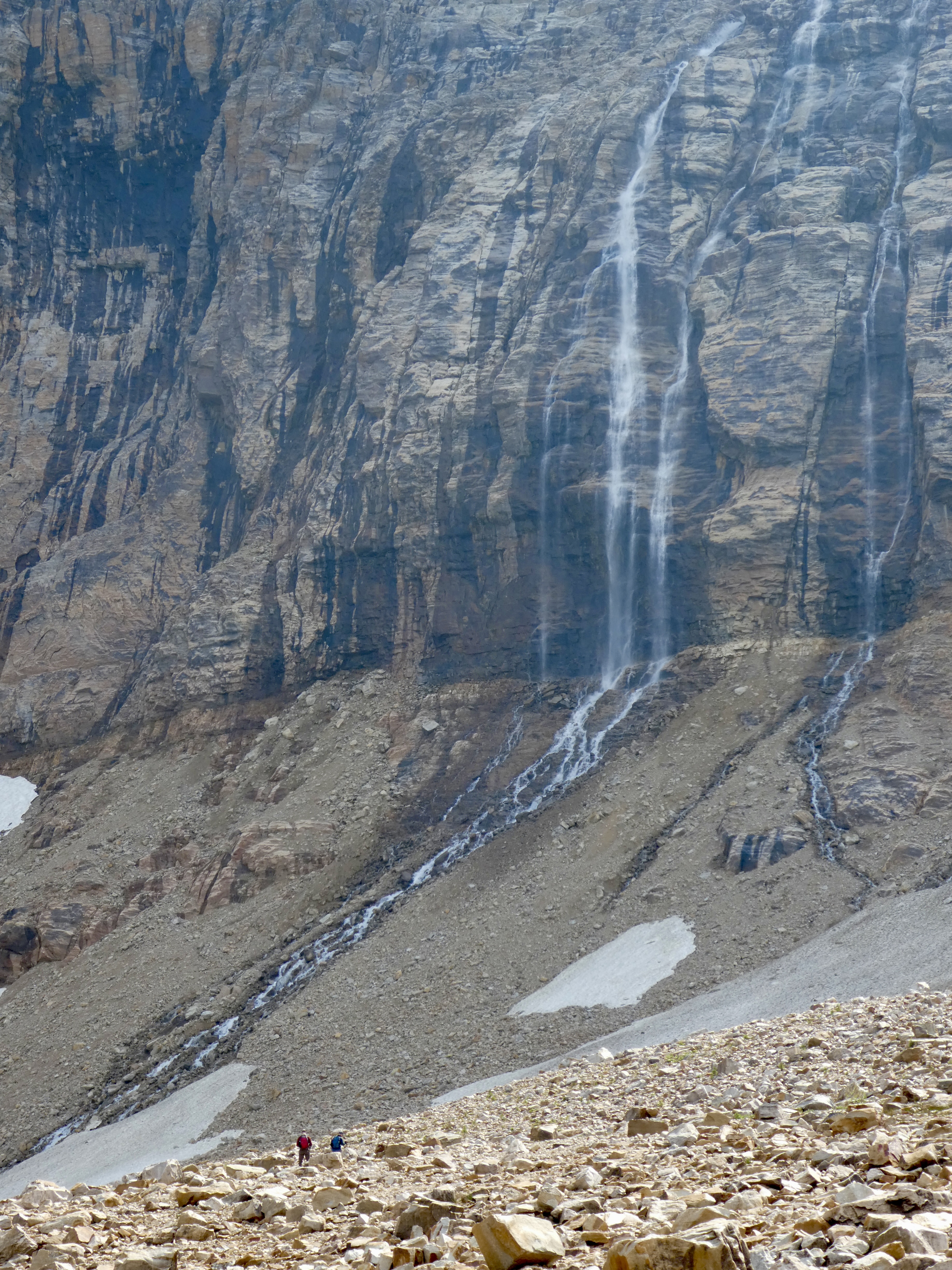 |
| These are the continuous falls |
“Do you see that?” she asked. It took me a few moments to get pointed at it but then I saw it. Was it falling snow or water? Unclear. She turned and was looking at something else but I was still looking up there and I saw the slide of material start to run off the top of the glacier and down a rock channel. “Hey, something big may be happening.” As we watched, a large amount of water broke loose and ran down the side of the upper glacier and then through the rocks and over the edge, cascading down. A large amount of… water, definitely water, falling down the sheer rock siding and landing on the top of the upper glacier. This waterfall lasted for maybe a minute. There must have been some lake of melt water up there and the ice dam broke and down it came. We thought it might break loose a hunk of the lower glacier that would then fall into the lake, but that didn’t happen. After the fall was done, you could see where ice had frozen on the rock face behind the water. We made a movie, you can watch it.
If I can get the video to load.
Which I can't. Well..... maybe
Our friends were off exploring across the glacial rock bed up near the falls. They were finding little plants that were growing in the rocks and such. I give you one picture for scale.


