Saturday, July 30, 2022

Cape Lookout


As you drive up the Oregon Coast you encounter bay after bay that has been created by three shared elements. Firstly, A river running from the local mountains into the ocean. It carries sand and mud and trees and puts them all at the coast for use. The river spreads out at the coast where there is a short ledge before the depths of the ocean. Next a sand spit forms forcing the river to run parallel to the ocean for a mile or so. The water backs up behind this spit forming a tidal bay, usually with a challenging bar right at the entrance to the ocean. The river, of course, has come down from the mountains in a river valley, that it cut itself. But this valley often extends out into the ocean so there are these bookmark highlands at either end of the bay that jut out into the ocean. This mix, with different recipe amounts for the river, sand, and bluff are repeated as necessary down the length of the Oregon  coast from the Columbia river to the Rogue. 

Today as we are driving up the coast from Lincoln city we were looking for a little hike to go on just as we passed the Boy Scout (now Scout?) camp called Merriweather.  This triggered a memory for me of hiking out on one of those highlands that sticks out into the ocean. This particular highland is especially Tall, Steep, Thin, and long. It is called Cape Lookout and it is a narrow finger of forested rock that sticks so far out into the ocean  that it completely runs away from the bays that it defines. It is actually quite striking to look at it on a satellite shot, so I have tried to include one. (If you are accessing this blog from sometime in the distant future, like the year 2000, then I apologize, the map company probably went  out of business. Wait, the map company and my blog company are the same company…).  There is a 2.5 mile trail out to a viewpoint on the very tip of the cape and I thought that might be a nice easy 5 mile hike for us today. 


The parking lot was pretty full when we pulled in. It is like 100 degrees in Portland this week and everyone who can escape to the coast has done so. Here we are only 50 miles west of Portland yet the weather is patchy fog with a temp in the 60s. Beautiful day for a hike. We have a lunch packed and plenty of water for this trip and think we are sort of going on a walk in the park. We are dissuaded from this a little by printed signs at the trailhead that warn of deep mud at the halfway point caused by ‘recent rain’. It hasn’t rained in Oregon in a month so we are a little suspicious that these are old signs. Though….. they don’t look all that weathered.  We take advantage of the nicely maintained bathrooms, pit toilets but clean, and then down the trail we go.

This trailhead is the start of three different trails. The one that we will take goes straight ahead out to the end of the highland. Another goes left and steeply down the cliffs to end up on the beach below. The third goes to the right and also steeply down but to the north, ending up in the state campground at the beach on the other side of the headland. The start of the 3rd trail was taped off and had do not enter signs, though there was nothing that said ‘Trail Closed’. 


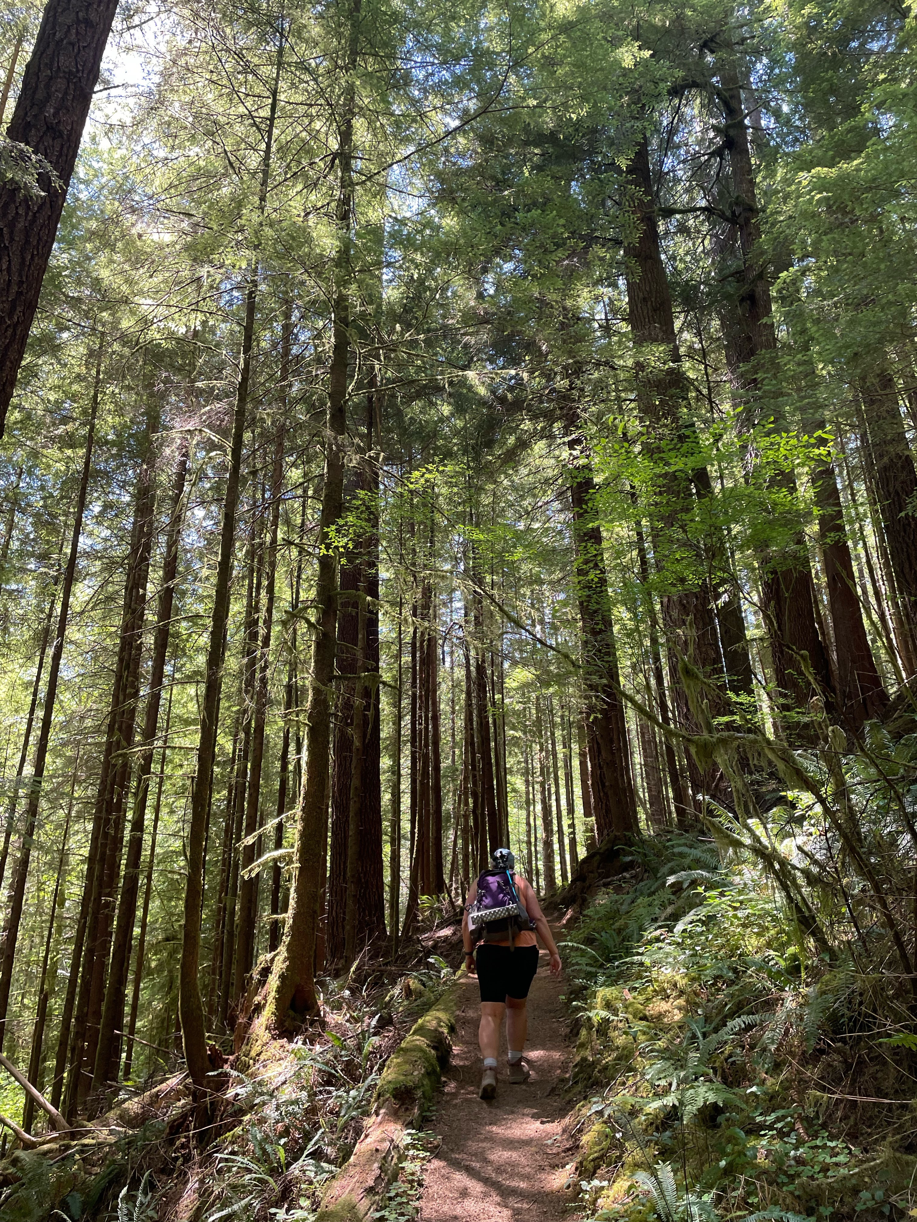
The trail we are taking is a nice one track trail, smooth with pine needles and small stones. It enters immediately into a forest of predominantly Sitka Spruce, many of them towering giants. To the north a steep up to the top of the ridge. To the South, a steep down through towering trees to the white sand of a beach and the Pacific Ocean. I feel that I have to give more description than just ‘steep’. I mean, it is steep, almost shear, but it is also very high. We are something like 600 feet up on this headland and though we are not on a cliff at this moment, you can see ahead where we will be. The view at this moment is fantastic, we can see several miles to the next promontory south of us and down below there are below like ants on that beach way way down there. 

About a half mile down the track you run into what may be one of the saddest and most ironic brass plaques I have seen. It is a memorial to a crew of a B17 that was flying along the coast during WWII doing their last training mission before being deployed overseas. They were supposed to fly to point desolation and were having trouble finding it due to the fog. The pilot took them down to essentially sea level to try and get below the fog but no joy. The started their ascent, and at around 900 feet, they hit Cape Lookout at 200 MPH. Though several people survived the crash, only one lived long enough be rescued by the party that took 36 hours to get their because they were in such a hard to reach location. The lone survivor clung to the cliff via a propeller imbedded in the mud and rock face.  I call it ironic because I am guessing the last thing the co-pilot said was “Look Out !!”. I have a friend that told me you can do a hike from the local Scout camp at low tide and still see remains of the plane that have slid off the cliffs. I have also seen accounts of artifact hunters that have found parts of the wreck along the top of the hillside.

Ok, so I have this problem. Several accounts I have read of the crash insist that the plane hit the cape at an altitude of 900 feet. But when I look up a topo map of the area, the map insists that the cape is only around 350 feet high. So what gives? The topo was not using meters, I checked. Google Earth says that though the highest point of the cape is around 300M, the place where the plane crashed is more like 200M. So there you have it.

After a few nice views the trail jogs right into the small flat land that is the middle of the highland. The Sitka are huge and thick in this area. They are 5 to 10 feet in diameter and a 150 feet or more tall. Century old giants that have seemingly reached the max that is allowed by the violent storms that must rock this headland from decade to decade. Many of the biggest trees have either been blown down, their rootballs making a staircase obstacle to our trail, or they have been broken off 30 foot up making for these huge stumps in the forest.


Note Fern Balls in Trees


The wind is blowing from the North and this has pushed the marine layer fog tight against the North wall of the cape such that cold wet fog is billowing up the cliff and into the trees. A steady but very light rain of big drops is falling, seemingly dripping of the branchs of the trees over our head. Perhaps this is the source of the ‘recent rain’ we were warned about. 

The trail winds back and forth across the width of the cape. The length of the cape is 2 miles, but the trail length one way is 2.5 miles. This winding, some of it switchback hill climbing must account for that other half mile. 

On either side of the cape, where you are up against the edge of the cliffs, it is rocky and dry. When you cross through the interior, in the flat area, there is often accumulated plant debris and standing water. In other words, it can be muddy. The misting effect from the North becomes more pronounced as we head out west on the trail and the rain becomes more pronounced. Still not enough to stop and put on a rain coat and still….. strangely local. My partner commented that this was strange weather and I replied that one would expect the weather to be the same 100 yards in any direction but it wasn’t. 

The plant life was pretty much the standard PNW array, but with a stronger mix of Sallal and Deer Fern. The Deer Fern was especially lovely as this is the time of year it is ‘blooming’. The bloom on the Deer Fern comes in the way of fertile fronds that have black stems and smaller leaves. 4 or 5 of them extend up from the middle of the plant to a height of a foot or so. These are the parts of the plant that create spores and are seasonal. They will die back after awhile. The sterile fronds growing around the base of the plant are evergreen and will last for several years. 

Deer Fern

The trail crosses over to the North side of the cape right about at the 1.5 mile mark. Here is your only good view looking North. Well, I have been told that it is your only view looking North. Today what we have is a thick fog bank such that we can’t even see the beach which is presumably just down below us. So after staring at the blankness for a bit we turn around to see the trail going up and south right behind us. There too are more signs warning about the impending mud. This must be really world class mud to deserve all of these signs. There are a few people out hiking (as one might deduce from the full parking lot) and we have talked about the mud with a few of them. Some have gone all the way through and they don’t appear too muddy. I mean, the tops of their shoes are clean. Others are turning back at the signs. In all fairness, they have come over a mile and have had a nice hike and probably don’t need to get all muddy. Plus the kids didn’t want to leave the car and their electronics in the first place, COME ON DAD, LETS GO BACK.

My partner has a different take. Though she chides me for suggesting that this was an easy out and back of flatness, she is intrigued with the adventure that the mud warning seems to imply. What a Partner !!

We break our trekking poles and slug up the hill.

Danger Will Robinson !!! Mud !!! Danger !!!


Tree Roots Of Death

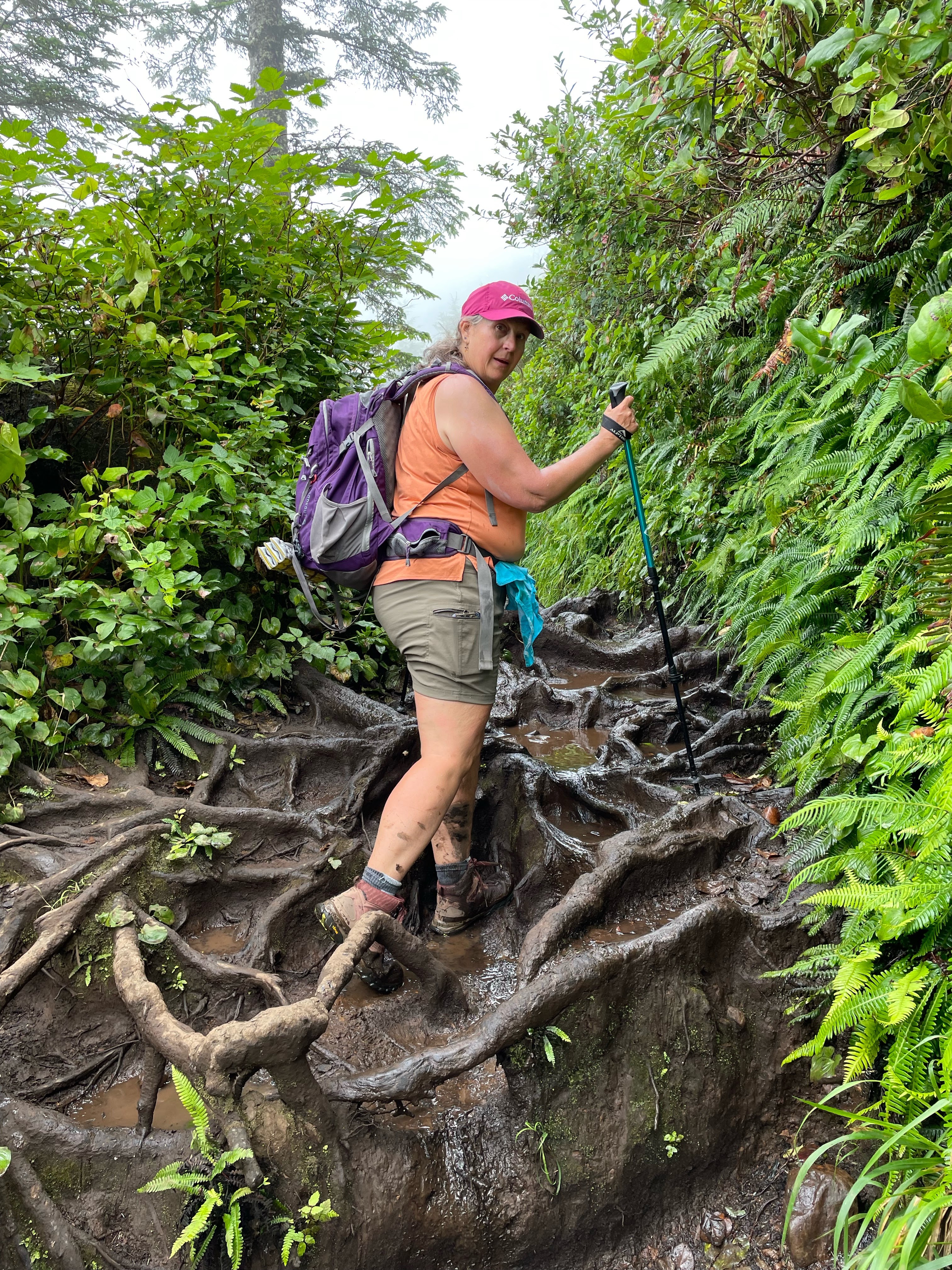
The issue turns out to be not so much one of mud, but of mud and water that has been captured by the large spreading roots of the Sitka. These roots form rounded foot size buckets that are distributed across the trail and which you have to slowly pick you way across. Well, if you are an agile youngster or have four legs you can probably make your way walking on the tops of the roots. If you slip off those shinny smooth, polished tops, however, you will go down a 10 inch hole, fall over and break your 65 year old leg bone. This would be non-ideal. 

My partner and I have a mantra for this summer. This is our ‘No Major Injury Summer’. No doing something slightly silly and breaking an ankle or a wrist. No surgeries. No New Knees. We are going to go slowly and carefully through our adventures. Today, this means putting our feet into many of these roundish root puddles. We are both wearing waterproof hiking boots and so doing this isn’t too much of a problem except that you really can’t tell how deep the holes are. Most are like half an inch of mud. But a few are more like 6 inches of mud. The poles come in handy for testing this but I still hit a couple of deep places and got mud almost to the top of my boots. Everyone we met coming back said that there was still more mud ahead of us but that the slug was worth it for the payoff view. 

I was noticing the people that we were passing. They were all ages though mainly over forty and fit. I think it would have been pretty easy for REI to set up a booth and film a commercial out here. Everyone was dressed like an advertisement for the Recreational Equipment Co-op. REI pants and REI sun shirts and carrying REI packs. I was comparing my new REI pack to some of the others I saw on the trail. Mine is nicer. 

Slugging through the mud and root traps is much harder and slower than the level trail. It took us at least another hour to do the 1 mile out to the end of the cape. And more than half of that mile was mined with Sitka Root Mud mazes. I sure hope the pictures can do it justice. As you zig zag back and forth across the now narrowing tip, you have to run into the cliff on the South side and when you do you are rewarded with semi-clear views looking south. You at least have a clear view down down down to the ocean below. We run across a couple sitting on the bluff. They are looking at a Bald Eagle in a tree 100 feet below us. My partner gets a picture. The couple tell us they are also from Portland, escaping the heat of the city. They have nice REI packs.  They also tell us that we are nearly to the end of the trail. We have heard that one before.  However, they are not wrong.


This tip of the trail has a large open space of rock and dirt and a little well worn bench to sit on. There are a few other people out there, everyone is eating lunch. One guy is eating melon and throwing the rinds over the cliff saying, “Oh, the seagulls love these. I do it all of the time”. I really wanted to tell him to quit throwing his garbage onto the cliff or into the ocean. How should one handle a situation such as this? Should I ask him if he is a Republican? I figure if he is a Republican, then I need a gun in order to have a discussion. If he is a Democrat, then I can threaten to report him to REI. ESPECIALLY since he was bragging about how his COSTCO cargo pants were so much better than his REI cargo pants. It is all in the quality of the sweatshop where the clothing is made, you know. You need one that employs very young children because they have the small hands needed for intricate work and you only have to pay them in small balls of rice. Boy, I am a grouchy old man. I can’t wait to get home so I can sit out front and shake my fist and yell “You Kids Stay off of my Grass!”.

So. A quick lunch and then we head back for the car. Turns out that going back the other way is mostly uphill. Just  a little. And uphil climbing through the muddy root traps is suprisingly easier than going slightly downhill. I think this is because you are effectively facing the ladder instead of not facing. (backing?).

That bald eagle is still sitting there in that tree way down there. Oh, and there is a flight of Pelicans!! I have never seen pelicans from so far above them before. Beautiful. 

We make it through the mud with all due alacrity, only stopping to talk to people and tell them how much further the Mud extends. I insist they are halfway through but they insist that is what the last few groups of people told them. 

When all is said and done, my Fitbit says I went nearly 6 miles. Is this because fitbit is wrong or is it because all of those little steps through the mud roots were bouncing me back and forth across the trail? I have this theory that FITBIT is telling you the perceived length instead of the actual length of your trek. Maybe it is the “as the geezer stumbles” as opposed to “as the crow flies”. Either way, I find that with a fitbit, I hike further. So I must be getting more exercise. I need a scale that auto-syncs with my fitbit so my fitbit can convince it not to read so high.


Friday, July 29, 2022

Drift Creek Falls


There are some names of places and things that get repeated all over the country.  For instance, we are visiting Lincoln City. There are cities named Lincoln in pretty much every state (and several called Lincoln City). We happen to be visiting the charming one on the Oregon coast. Then there are common names for creeks and rivers. Falls Creek. Fall River. Elk Creek. Swift Creek (lots of these) and Drift Creek (lots of these also). Today we are taking a little detour just short of Lincoln City to go off on Forest Service road 14 to find our way to the trailhead for Drift Creek Falls hike. 

I had always thought of this as a hidden little hard-to-get-to hike. I thought this because the map has it way out in the forest down this forest service road that last year was listed as ‘closed about a mile from the trailhead if coming in from the coast due to a landslide’.

Forest Service roads are usually the roads that have been cut to get into the forest to provide service. The main service is the forced removal of said forest to make houses and firewood. These roads are usually gravel or just dirt and often are best served using a 4 wheel drive vehicle. The guide book says the roads are good all the way to the trailhead and you can access said trailhead from the North (off of highway 18 on your way to Lincoln City from Salem) or from just south of Lincoln City). We came in the North on what started out as a wide but well maintained gravel road but then turned into a 1.5 lane paved road winding through the thickly wooded forest. We had got ourselves into a little caravan of cars (which was unusual) and immediately ran into a Tractor Trailer rig pulling a full load of felled big trees. All  cars had to back up and find one of the frequent wide places to get out of the way. It turned out this was sort of unusual, because we didn’t  see any more trucks on that road nor any more cars going in that direction (the operative phrase being ‘that direction’).

Word of Warning here: If you are coming in from the North, don’t trust Siri. That little trickster tried very hard to take us the long way around, essentially routing us out to the beach and then up the long way from the south. Sneaky. We were lucky enough that the car behind us knew the right way to go. There was also a big sign that pointed straight ahead right at the V in the road, but one could argue that straight ahead was in either direction.

Anyway, we wind down the road being careful  to avoid oncoming timber trucks until we came to the trailhead. I am thinking, well, here we are 10 miles out a little one lane forest service road, we are going to be the only people at this little secret hiking spot. 

WRONG

The largish parking lot was full and more cars were streaming in even as we parked on the side of the road. All sorts of people there. Lots of teenagers and children. LOTS of teenagers and children. The trail started out up on the ridge and then you hike down to the creek and around to the waterfall. So we are going downhill first (this is my second favorite direction only losing out to the exact opposite of this). The initial part of the trail is through a forest of relatively young Doug Fir. It is a well maintain forest, however, and the trees have good separation and are healthy. Even with my new knee I guess I cannot maintain a very fast pace because we were passed by Everyone. Big groups of people. We would pull to the side when things got too noisy behind us and groups of 10 or 15 would go past. Families with everyone along. Even grandma was passing us laughing with her grandchildren. We must have seen at least 50 people on the trail, which pretty much matches up with the number of cars in the parking lot. With this many people, things are not quiet. Lots of laughing and talking and a fair amount of whining. 

The trail continues down through this young forest (I am guessing the big trees were less than 100 years old. Perhaps as little as 50.) as it winds its way down to the river. I can hear the river off to the right. Other than the age of the trees, this is a typical healthy wet Pacific Northwest coastal forest. Lots of Salaal. Some Oregon grape. Plenty of sword fern. Some less usual plants that we saw included Salmon berry and a new fern that I will get to later.


At the bottom of the slope, after about a mile, you come to a footbridge over a little gurgling stream.  As you cross the stream you enter a grove of old growth cedar. Big trees that seem to have avoided the lumber man's saw. Perhaps this side of the valley was too difficult to access. Certainly the lumber roads are not running through here. This entire area is part of the Siuslaw National Forest, perhaps lumbering is no longer allowed on those lands. No, I checked, BLM and Siuslaw National Forest work together to manage the land (that means, cut down the trees).

Now the trail follows the creek through this stand of lovely big trees. I have never done this hike so it is unclear to me what to expect next, but I know there is a waterfall someplace along here…

Then, up ahead through the trees, I glimpse the towers of the suspension bridge that I saw on the map. I expect it to be going over the creek that we are following (on our right) but I now realize that this bridge is much larger than I had been expecting and is going off out of my view to the left. 

We come around some trees and pull up next to the little stream and I can see that we are standing on some prominence, perhaps a cliff, and the bridge is reaching out over the void to a cliff wall 100 feet across a river gorge. Oh boy.  The bridge is just barely wide enough for 2 hikers and is a classic 2 wire suspension bridge. We start across. When you get to the middle you can look back and see the wonderful little falls that is the cause of all of this engineering. That little creek that we were following has spent that last centuries digging a little gorge through a lava flow up high. But that lava flow ends and so the creek must come bursting out of its gorge and making a lovely little fall into a different creek/river 100 feet below it.  It lands on a jumble of large boulders that have calved off from the lava flow up top and now provide a place for intrepid youth to clamber for a better view of the falls. 


We stop on the other side of the bridge to admire the view, but the trail goes on and my partner gets me moving again to continue to the end. It goes off down the main river and then switch backs down to a nice view at the base of the falls. Be careful here, there are a couple of places that the trail is made of closely packed round river rocks and dirt, and when wet, are incredibly slippery. Like so slippery you can’t walk on it without extreme care. 12 year olds appear to have no problem. I wonder if their shoes are especially sticky.


This is a great place for a snack and some re-hydration and to talk to some of the people on the trail. We are probably the best prepared hikers on this trail. It is only around 1.5 miles from the trailhead to the falls and many people are in sneakers with no packs or water. I always hike with my trekking poles and water and once you have to carry that, you might as well bring the full 10 essentials that are printed right on many of the REI packs. I actually do carry many of the 10 essentials. I have a knife and a compass and some waterproof matches. I also have a tarp and some rope so I could build an emergency shelter. I usually have a bivy sack (just a sack made out of that space blanket material). My general goal is that I could survive if I fell and broke my leg and my partner had to go for help. Perhaps over night. My real goal, if I am being honest, is to appear prepared enough to impress whomever I am hiking with. For instance, some of the things I have brought out to hand to people: A snack. Some toilet paper. A square neckerchief to tie around a cut hand. A rain and wind shelter.  A extra pair of socks.  I used to carry a little stove to make tea, but I don’t usually do that in the summer. I have this idea of setting up a little tea stop up on a heavily used pass in the Columbia Gorge some cold fall day just serve tea to people as they pass by. I haven’t quite got up to that yet, though I think it would make a great story.

On the way back to the car, we do a signed side loop called ‘The North Loop’. It starts just after crossing back over the other smaller footbridge and winds away anti-clockwise up the slope adding about another mile to the trail. It is a much less traveled trail and my partner, who was leading, had to do some Salmonberry clearing to get through. Salmonberry is particularly grabby, with lots of little thorns that you think you can ignore until you see the blood on your arms and legs. Once through that we were back into some big trees. Bigger than the start of the hike. This is also where we ran into this new, to us, fern. I had though it must be deer fern, but it wasn’t growing on a maple tree. It has a leaf pattern similar to deer fern and it has long black stems. They were growing everywhere along this part of the trail. The internets tell me that it is, well, it is Deer Fern. Further it tells me that Deer Fern has two kinds of stems. The usual green stem around the base of the plant is sterile. Then the upright black stemmed fronds in the center are fertile and short lived. This makes me think that I don’t really know what that kind of fern that I see growing on the giant leaf maple trees over in Portland are. There is always more research to do.


It was nice to get away from the crowds on the North Loop, but we soon met up with the main trail, up on top of the ridge, and then had another half mile of being passed by pretty much the same people we had seen on the bottom before we got to our car. We had sat down once to take a little break and see the people go by, but we got a little swarmed by biting flies, so we got going again. Not sure I have ever been swarmed by biting flies in the PNW before. Must be attracted by all of the very edible humans. 

Back at the trail head and the parking lot is now only half full. Truth be told, we have made this excursion to the coast to escape from the heatwave that has been predicted in Portland. 100 degree weather in the Willamette Valley but it is going to be 60 or 70 on the coast. You never know if you have enough warm clothing when you venture to the Oregon coast. We are staying in one of our favorite motels, The Inn at Spanish Head. All of the rooms have balconies  overlooking the beach and I am sitting out there early in the morning, listening to the waves, which I know are out there someplace but I can’t quite see because of the fog, while I type this blog. I  Wonder if the fog lift by noon?


Sunday, July 17, 2022

Scappoose Bay at Flood


Had a wild paddle in Scappoose bay last week. We have been having an extremely rainy spring and all of the rivers and streams have been in near flood stage for a few weeks. The Columbia is just getting ready to crest at just a little below official flood levels. The river is higher than I have ever seen it and this really fills up Scappoose bay (which is really just a little offshoot of the Columbia river sort of in the general confluence of the Columbia and Willamette). Now the water level in the bay is often high this time of year and I have written about other expeditions up into the trees of the little offshore islands, but this year the river is about a foot higher than I have seen it.

The other thing is that this water is relatively clear and clean, so you have pretty good visibility into the plants and things that are now below the surface. I am not saying it is actually clear. Just clear relative to usual. Maybe 1 to 2 feet of visibility. We could certainly see the Blackberry bushes down underwater at the kayak launch ramp.

We had the idea that we were going to do some bird watching and try to find our way to the Great Blue Heron rockery that is down at the east side of the bay.  This can be very hard to get to at low water, but at high water, you just need to know which direction to paddle in.  And that is pretty easy as there is good cell signal out there. 

So we go off paddling and decide that we will find our own trail through the trees. At this depth of water, there is pretty much nothing stopping you from paddling except the tree trunks themselves. All of the usual brush of blackberries and brambles and marsh grass and fallen logs and stumps are all a foot or two underneath you and you can just glide on through playing zig zag through the trees. We took turns leading and it is fun to glide through the trees using your paddling skills to avoid the occasional low hanging branch or floating log. 

We eventually came to a open waterway that I recognized as the major stream through the wooded area that is usually the way you would go to get into the interior of the island during normal water levels. Today we just used it as a landmark and followed it around to where we could see the big trees that we though were the GBH rookery. 

As we glided up toward the big oaks that the Herons were nesting in (we can hear them) we are crossing a big open expanse of water that a few weeks ago must have been a grasses filled meadow. We can tell because we can see the seed grain heads of the grasses waving a few inches below us underwater. Just enough are sticking up above the water to coat our boats and us with seeds and such. The grass allergic amongst us were not having fun at this point. 

We paddled past where the Heron were to get around behind the Rookery. You can’t normally do this because we were paddling in what was really a farmers field, but we certainly weren’t hurting anything today. We heard this ruckus noise that went on and on that I identified as someone trying to start an old truck. But then we saw some movement in the trees and it became clear that the Herons were making that noise squawking at each other (or perhaps at us).  The noise they make and the way they commit to a lumber launch into flight makes me think that this is what pterodactyl must have looked and sounded like. Great huge noisy flying machines.

Later we were starting to paddle back and I was skirting some thick trees when I came to a place where real grass was growing on what was apparently a mound above the water. Just as I got close, a beaver say up, gave me exasperated look and then turned around and lumbered into the water. Turned out he was probably asleep on a big floating log (perhaps a man-made thing) that had grass growing on it and was probably one of the only dry flat places in the area as it floated up with the flood. 

We went back through the trees on the way home and found our way out to the lake that is in the middle of the little island. Of course, with the water this high the lake is just the place where there are not any trees. 


Just as we got back to the launch site, we saw an osprey stooping in for the kill. He was way high up and did sort of 2 stoops and then hit the water with a great splash. And then. He stayed in the water. He tried to get out a few times but just couldn’t quite do it. He was just lying there sort of on the top of the water with his wings all splayed out looking like he was tired and perhaps hurt. He did another big attempt at getting out the water and we could see that he had himself a fish. A Fish! Perhaps too big a fish. A fish so big that he couldn’t get out of the water and back into the air carrying it. He finally gave up and flew up out of the water with his claws empty. He circled around and landed on a piling sticking out of the water over near the island, looking a big disgruntled. I am sure he was thinking “How am I going to explain this to the guys? They are never going to believe the size of that fish!!” 

See, I figure all fishermen are alike even if they are really fisher birds.


Deschutes Float - La Pine to Big River


The headwaters of the Deschutes River is up in the Cascade Lakes that we were paddling earlier in the day. One can argue (and apparently one does) as to where the actual headwaters are, whether in the Lava tubes leaving Sparks lake, the runoff from Hosmer, or the well defined river leaving Little Lava, but all of that dumps into the wickiup reservoir and then comes spilling down the hill toward the big rapids just above Bend. From Wickiup to Sunriver, the Deschutes is mainly flat and winding with a few areas blocked with deadfall and such, but no real rapids (well, mostly).

We are meeting with our kayak group at the boat launch at LaPine State Park for a float/paddle the 10 miles are so down to the launch at Big River campground. This is the last day of 4 days of Kayak Portland Meetup summer fun in the Bend area. We did a couple of the lakes up the high Cascades and we did a little fun paddle through Bend on the Deschutes there. There are around 20 people on the trip and they are staying all over the area. A few are in LaPine campground (as are we) and some are primitive camping up in the hills. Some others have hotels or rent-a-house in Bend. So all of these people need to meet at LaPine boat launch and then we have to organize some sort of shuttle to get the cars down to where the boats will be at the end of the day. My partner says that she doesn’t like to be involved in the organization of the shuttle because it is stressful and everybody has an opinion. She was right. The problem was that everyone else's opinion was wrong. OK, that is half a joke.

The trick is this….. what is your real end goal? Is it to get ALL of the cars down to end point? If so then you need at least one car that is going to carry all of the drivers back up to the starting point. To do that, you have to wait for all of the cars to arrive. Then you have that one driver who brought everyone back up to the top, his car is now at the top so someone is going to have to bring him to it at the end of the paddle. So everyone else will be loading their boats and heading to the group after paddle party and that person is going to be driving back to the bottom to pick up their boats. A more equitable method might be to take just the number of cars you need to carry the drivers and leave them at the bottom. This has the other advantage that you don’t need to wait for everyone to get the shuttle set up. You can spend an awful lot of time waiting around for a shuttle to run if it takes 20 minute to get between put-in and take-out.

The best thing is to have a few extra drivers who are not going on the paddle, but that trick seldom works. I think that along the Willamette river on the other side of the Cascades there are shuttle companies that will take you do your drop in and then pick you up however much later. I must look into that some.

But we finally convince everyone to stop talking and get working and get all 20 boats into the river and start floating down. And what a beautiful float. The water is chilly but not freezing and the banks are lined with majestic Ponderosa and scraggly little lodge pole. There are some water fowl sharing the river with us. Some mallard but mostly merganser duck. We see a group of deer.

The land is pretty flat here and the river wanders back and forth at it’s leisure. There are many places where it is a little difficult to tell which way the river is going. This is caused by the many partial or complete  oxbows that have formed in the river. In many sections there are groups of large well kept houses crowding the river. Some are up at the top of tall (50 foot) bluffs. Some are down in the flood plane of the river. Many have elaborate protections against erosion in the form of concrete or stone river banks. One place we saw half of an old log cabin hanging out over the river. The other half was long gone. In many places you could see where trees growing on the shore had been undercut and had fallen into the river (or would soon). A good reminders that rivers are changing things and  the place where the main current is today could change in any one big flood season. Of course, the reservoir at Wickiup does a lot to control the changes in the river, I wonder if it does enough? That is probably bad thinking on my part, there must be parts of this ecosystem that depend on the changing of the river and the flooding and the dam limits those changes perhaps to some ill effect.

A number of people float down these sections of the river in tubes or rafts. You can see evidence of this in the things that they lost. We saw some shirts, some shoes, an entire backpack (that we just couldn’t quite get to). Imagine floating down the river with you valuables in you backpack and you slightly drunk best friend from college flips you over. Your wallet and cars keys disappear into the water (you really should have put some flotation in there, Dude). Of course, the joke is also on your friend since it was you car that you parked at the bottom take-out and now you are both walking back to the top.

No rapids or other water excitement on this section of the trip unless you make it for yourself. Like when I reached over to grab a rock in the shallows that I thought might be an agate. I reached to far and flipped my kayak. It was shallow so I sort of held myself up on my paddle until my Partner could paddle over the lend me her bow to right myself. Sort of embarrassing. I also hurt my shoulder. 

And on we float. The take-out at Big River is easy to find because it is just after “The Second Bridge” from LaPine. So if you can count to 2, you can find it. Also, it is better if you don’t have the big car that can carry the most drivers, then you won’t be the guy whose car is at the top whilst everyone loads up and goes off for the farewell party.


Saturday, July 16, 2022

River Notes 1


When Paige and I started to paddle down the middle reaches of the Willamette river, say from Salem to Saint Paul, we found a number of excellent places to hunt for rocks. Two large island rock bars were particularly fine and we even camped out on one of them a number of times so that we could use the low rays of the setting and rising sun to hunt out those allusive agates that hide during the heat of the midday. 


The first of these places that we found was the Candiani Bar. It is just upriver from the county park near Saint Paul that is called San Salvador. San Salvador is an old steam boat landing that sits amongst a farmers field a good mile outside of the little town of Saint Paul proper. It is just a little unpaved dirt loop with parking for around 15 cars and a little concrete slab boat ramp. It is a popular place with the locals for an afternoon swim or some fishing and goes up and down in seediness perhaps dependent on whether or not someone has decided to pick up trash there or not. It needs a pit toilet and a trash bin. 

I don’t remember how Paige and I found it, no doubt in one of our river maps, but we decided to go there and see if we could paddle up stream to this big rock area we could see on Google maps that was called Candiani bar. It was only about a mile or so up stream.  

At the time, we didn’t know what we might be getting ourselves into and the water was cold and running fast, so we put on our cold water emersion suits (so called dry suits) and struggled into our spray skirts and headed up the river. We started out on  River Right (The right side of the river going down stream and as it happens, the bank that San Salvador is on) and worked our way up river toward a little back eddy. The river was pretty strong there near the landing, but even stronger out in the middle of the river. The river was maybe 150 yards wide at this point. 

When you are paddling upstream in a big river like this, you need to go searching for the slow moving water. Often the water will be slower, perhaps half as fast, close to shore. There are lots of small obstructions, like down trees and underwater rocks, that divert the flow and create tiny back eddies that make the water near shore move more slowly. Of course, that water is also more shallow and you can run aground on those submerged tree trunks. 

that is a buzzard


A one day haul


This year we were about halfway to Candiani, we had just turned the corner and could see the tip of it, when we realized that we just were no longer making any headway. We had been forced away from the shore by a downed tree and the current was such 50 feet from shore that we were not making headway even though we were paddling as hard, or perhaps a little harder, than we could sustain. 


Across the way we could see a smaller and less inviting rock bar that we decided to cross to. If nothing else, we could pull up there and rest a bit. 

When you cross a big moving river like this, you want to get to the other side without being pushed downstream. You don’t want to lose the last 10 minutes of paddling in 1 minute of backward drift. That way lies insanity. So you use a maneuver called ferrying where you angle your boat at around 45 degrees to the current and cross with what you hope is a relative forward velocity of around zero. It is a strange experience, especially in water shallow enough to see the bottom. You have this sense of fast motion, with the river slushing around you, but the bottom below you is barely moving as you sort of slide sideways over to the far shore. 

We hunted rocks a little on that little bank, but it was pretty picked over and also covered in a thin patina of dried scum that makes it very hard to distinguish rock types.  However, the water was shallow and running slowly over there so we could make another hundred yards or so of progress up river toward our real destination. Just at the upward tip of the bar, the bank became very steep. Usually the land below water looks just like the land above water. So a steep side means deep water close to shore. Deep water often means fast moving so we once again were having a hard time progressing. We struggled on a few minutes until we thought were far enough upstream that we could make it to Candiani on the crossing. And then we crossed. This was another hard crossing with Paige in the lead but we did make it over to the shallow water near the Candiani Bar and from there we could manage to paddle upstream to where there was a good landing on the bar itself. 

Candiani Bar Circa 2015


Stick Stove Cooking... yum


Oh my, the rock hounding was incredible. We searched for an hour or so and both of us filled our bucket with agates larger than we had ever found. (It turns out we had never really found very large agates). Hunting for agates on the Willamette is different than hunting them on the beach. Beach agates tend to be much smaller, white, and rounded by surf. River agates come in white, red, and orange, and are usually found by their rough texture or by a very shiny edge caused by a recent (last hundred years?) cleaving of the rock. There were so many agates out on the bar that we were playing a little game where you could not move from the place you were standing until you had seen a agate and were going to that new place to pick it up. Often you would be seeing 2 or 3 and had to remember where they were as advancing. Because you are often seeing an agate from light reflecting off of a smooth edge, if you move a little you can lose sight of it. 

Immature Bald Eagles


Hunting Lambert Bar


The other bar we found is called lower Lambert Bar and is right at the outflow of the Lambert Slough, just across the river from the Lambert bend. Note the pattern here. If you look at a sattelite view you can clearly see this large fan of light colored area (rocks). Close you eyes and imagine how the river must have been flowing over that area to make that pattern. The rocks would have been rolling around with tree limbs, hell, entire trees, plowing through. All of the vegetation, even bushes and trees, would have been ripped out and small heavy things, like sand and pebbles, washed down in the flood. The last big flood we had was in 1996. I figure that is the last time this hunk of land had been truly stripped and turned and made ripe for rock hounding. So why did it wait more than 10 years for Paige and I to get there?


The section of river that Paige and I most like to run (partially due to convenience of location to our home) is from the ferry at Willamette Mission State Park to the take out at San Salvador. This is around 15 river miles and during that distance there are no bridges or public landings or anywhere that is easy for the public to access the river. There are lots of farms around and places where farmers kids can drink beer and have a party, but you can’t drive your city car up to the beach. Lambert Bar is even harder to get to and essentially inaccessible unless you have a fast boat or are willing to float 6 miles down to it and another 6 miles to get away from it. As you can tell from the picture, the bar has some growing trees on it. The upstream end is pretty well covered in dense foliage. But the downstream middle of the island was all exposed rock. Nothing growing there at all. And the rock was a nice size for finding big agates (say around golf ball size). The first time we stopped there we had just spent a half hour or so checking things out. But later that season we spent the night there in a little grassy area over on the river left bank. 

It was an idyllic and somewhat ironic scene. Here we were, the only people we could see for miles. Sitting on an island in a big scenic river. We had a little campfire going and we had our tent set up. This part of Oregon is blessed with a dearth of flying insects, so the nighttime wasn’t bad. Right next to our campsite was a growth of wild Himalayan blackberry. This plant is an exotic invasive in Oregon, but on this trip it supplied us with am ample bowl of berries for breakfast. We hunted rock in the revealing rays of the setting sun and we went for a swim when we got too hot. Pretty great.


Then around 8:00 at night, a band started playing. Somewhere, at some farmers home, someone was having a big party, perhaps a wedding. The music blared loud enough to keep us awake until around 2:00 in the morning. Ha !

We have found a lot of nice rocks on that island. Our most recent visit, however, found the interior of the island overgrown, much of it with the afore mentioned blackberry. The rocks are covered with grass and vine and the rock hunting isn’t so good. In fact, all of the little places that we used to go hunting in rock beds have pretty much been reclaimed by nature and covered in grass and brush. What is up?

I guess we are waiting for another flood of 1996. With the strange weather being caused by global climate change, I don’t think we will have too long to wait. And one must always be careful of what one hopes for.


We had a lot of rain and local flooding this year, but it didn’t come anywhere near to raising the Willamette to the flood levels of 1996. Paige lived here then and she told me of going down to the park that is near the confluence of the Willamette and the Clackamas and seeing the parking lot for the local McDonald’s flooded. That is a good 10 feet higher than the river was this year. That would certainly put some water over the top of Lambert bar. All of that quick moving water would tear out the blackberry and the grass and move rocks and trees through the area and plow things up good. 

It would also re-arrange the river. 

Even the water we had this winter changed things a lot. At the Candiani bar, there is an area sort of off of the main beach where in previous years there has been some good exposed rock. We walked back there last week and found that the water had flooded in and brought with it a load of sand, covering the rocky area we used to hunt. So the water is coming up and flooding things, it just isn’t moving with the force necessary to move rocks and bushes around. 

There is a new developing bar downstream from Lambert that I would like to check out. One of the things about floating the river is that you have to choose which direction you want to go around any island in the river. Do you choose the “main” channel or the “back” channel. I use quotes because sometimes it is hard to tell which is which. You make you choice and you ride your river. Lately we have been going around the back channel of Lambert because that is where (we think) the best camping spot is. That means we haven’t been getting access to the rock bar downstream on the Main channel side. Need to hunt that next time. Being ever optimistic.