Friday, October 28, 2022

Silver Falls Water Level Comparison Hike

North Falls. This was our Lunch spot. 
In the Cave under the falls out of the rain.

We had a very dry summer this year. No measurable rain since June. So even though the spring was extremely wet, we still ended up with very dry rivers and yards here at the end of October.

Usually for Halloween, my yard is green and alive. We have had now a couple of days of rain on the 24th, but the yard is still brown. Maybe it will be green by the weekend. My friend Chip and I headed out to hike Silver Falls today. Even though it rained on us for the entire hike, the rivers and Falls themselves were lower than I have ever seen them. I thought it might be educational to show a few pictures of high water and low water on the falls. The big flow pictures come from a hike that my partner and I did out there last December. 

I was also trying out my new raincoat. It seems that Gore-Tex has released a new color, because all of a sudden some of my top providers of rain gear (Arcteryx, REI, and LLBean) all have very similar Gore-Tex jackets out in orange. I got the Arcteryx and the LLBean and compared them and decided to keep the Bean because it fit me a little better than the Arcteryx, had more pockets, and cost half as much. The REI jacket was cheaper still, but it was made from the lighter 2 layer version of Gore-Tex and I was looking for something heavier. 

As Chip and I headed down the trail to the first waterfall on the clockwise loop (South Falls) we ran into a bunch of guys that were working carrying fence railing down the trail to the bottom of the falls. They were all wearing jackets and shirts the same color as my jacket. Turns out it is prison work release program Orange. I still love it. And I am very easy to see in a crowd. Except a crowd of inmates.

Chip says I should have waited and gotten one of the new Black and White striped ones that are coming out next year. 

A little trivia about the trail we are hiking today:

1) Silver Falls State Park is 90 years old this year. 

2) It is a park built around 2 rivers, North and South Fork of Silver Creek. 

3) There are 6-10 large waterfalls in the park (depending on season and rail fall.)

4) The 7.5 mile loop trail crosses river 4 times but there is only 1 bridge. The other 3 crossings are under the river. Really.

5) The little lodge has a nice fire place with a log fire and coco or coffee. Since it seems to always be raining and cold when I go there, this is a good fact to know. 

A lot of water running around on the trails today, by the end of the hike. The ground is still hard from the summer. 

When we needed a place to stop for lunch (at about mile 4.5) we decided to stop in the under cut of North Falls, where the river passes over you. There are benches in this large cave dug by the falls and we could sit there and watch the fall and not be in the rain. 

OK, here are some pictures...


Lower South Falls


I forget the name of this one.


Upper South Falls.


I don't have before and after off some of the other falls as I took different loops these two hikes. Anyway, I think this shows the difference a  little rain can make.


Friday, October 7, 2022

PCT - Timberline Lodge to Zig Zag Overlook


I have done some hiking around the base of Mt Hood, mainly a few times to Ramona falls, but I have never done anything significant up at the timberline. I don’t know why. I guess I didn’t realize that the Pacific Crest Trail runs right behind Timberline Lodge nor that the PCT is part of a trail that circumnavigates Mt Hood at around the tree line. Both of those things sound pretty great to me especially since I had set this personal goal of losing enough weight and getting myself into good enough shape to go out and hike part of the PCT (I had not been silly enough to mentally designate a particular spot or length of spot, mind you. But at least one night). 

Today we have some good friends visiting and they had a personal reason for wanting to go to the section of the PCT that overlooks Zig Zag river gorge. Zig Zag, besides the curious name, is a glacier on Mt Hood and so the headwaters for the Zig Zag river that comes rushing down from the mountain through Zig Zag (where lies the Zig Zag Inn and Zig Zag CafĂ©) and then into the Sandy River, which itself is coming down from a different glacier. 

We pick up the trail in the parking lot for the Timberline Ski area. In the winter, this would be a big deal. There would be lots of ice and snow on the drive up from Government Camp, the (huge) parking lot would be full of snow and Subarus and you would need to have a Snow Park Pass on your window. But before Nov. 1, None of those things are true. The sun was out, it was like 75 degrees with a crystal blue sky, the parking lot was empty and it was free to park there. Mt Hood was looking positively naked with perhaps the least amount of snow I have ever seen there. Usually at this time of year they have already had at least a dusting on the mountain (it is Mid October 2022) (if you are reading this in 2042 you are probably thinking, ‘Wow, there used to be snow on Mt Hood. Imagine that’). 


We parked at the trailhead and then made our way up through the Ski Lodge (for a bathroom) and so around the main lodge to meet up with the trail. In doing this we are passing through the main skiing area and under the ski lifts and such. It is a very different area with no snow. I mean, I have never been skiing here but I have looked down at the area from the lodge in winter. Everything is dirt trail with scattered trees. The dirt is white volcanic and glacial dust so there is a very Brown-and-Green on White effect. The trees are the low stubby things you would expect to grow right at the edge of the timberline and the area around the ski resort has had the trees with temerity to grow out in a relatively open area cut down so they wouldn’t be hit by a wayward skier.  Timberline has a lot of big lifts. It made me wish that I had done some skiing here when I was young enough to enjoy it and, you know, survive.  I had a little day dream of being a millionaire and buying up a few rooms in the lodge for myself and my extended family and then everyone going skiing and meeting in the lodge in the evening for conversation and dinner. It was a very short day dream because that was all I could afford. 

Timberline Lodge is on the South(ish) face of Mt Hood. Zig Zag is off on the SouthWest. So we picked up the trail (it is marked in a few places) and made a left turn to head clockwise around the mountain. The lodge was built in an area that was already sparse of trees and had a more gradual slope to it. Probably because cliffs are so hard to Ski. We hiked through this area at first. There are many seasonal water courses that the weather has dug into the mountain. Most of these are dry as this the very start of the wet season. When the trail turns and dips into the little gully the area around you is open and you get a good view of the mountains and lakes to the south. I am not sure of the lake names. I thought I could identify Mirror lake and Trillium Lake, but then I decided that Mirror had to be more off to the right on the other side of Ski Bowl. Hmm. Once again I need some sort of map kind of thingee. 

The trail does a little bit of a drop, perhaps a few hundred feet, during the course of the hike. But that is enough to bring us into a much more forested section of the trail. Bigger trees. All pine and fir. Lots of what is either blueberry or mountain huckleberry (no berries this time of year). On the big open areas, growing in the rock scree, there is occasional blueberry giving some autumnal color. 


little zig zag

About a mile in we come to a largish gulley that is still damp down at the bottom. This is Little ZigZag river (creek?). During the summer it usually has some water in it and the guide book says you have to use stepping stones to get across with dry feet. We only saw damp earth. It is about a 100 foot descent to the stream and then a quick climb out. The gorge is all rock and dust and boulders. There is some stone crop growing in patches. Was this all dug by the retreating glacier or is this just the result of water erosion?

At the top you get back into the trees and now you see lots of little flat areas where people have been camping. This is the PCT and lots of people do through hiking along it. If I was through hiking, I would have spent my night at the Timberline Lodge and not at a No Water site a mile away. But maybe there weren’t any rooms.  We did hit one little creek that was making just enough water to fill a water bottle, so maybe people were walking over to that. 

The next big gulley looks like it should have a bigger creek in it, but it is bone dry. I can hear a loud water noise however. We hike through the bottom of the gulley and start up and there down below us I can see a substantial creek, just coming to life in the middle of the gulley. The water was underground until then. This is the neat little secret of the mountain streams. The land around here is all glacial silt and volcanic dust and rock. Very porous. The water is seeping down from glacial melt and staying underground until it hits some solid rock base that forces it to the surface. During the high summer, where there is a lot of melt, it is probably percolating to the surface a lot further up the mountain, and places like this have running water. At this time of year, just before the first rain/snow, not so much. 


There are signs up at the trail heads warning about crossing these mountain streams. They can be very dangerous when their flows are up because 1) They are very cold 2) They are faster and deeper than they look 3) they have largish rocks on the bottoms that make for lousy footing. People die crossing them on a regular basis. They recommend crossing in pairs using each other for support. They also recommend that you do your crossing of the major streams (like Zig Zag and Sandy) early in the morning. Why early in the morning? Because the streams are significantly smaller in the morning before the sun has come up and starts the Glaciers and snow melting. During the late afternoon the streams can be twice as large. Think about that, if you are doing an out and back you could cross in the morning with just a little difficulty and then get back to the same place at 4:00 and realize you are in serious trouble. 

ZigZag River Gorge Overlook

actually a pretty big stream, just far away


We round another bend and we come to an obvious place to turn around. The trail comes right up to the side of the gorge over Zig Zag river. Down below, several hundred feet, is an active flowing creek. The gorge extends steep and rocky up to the right all the way to Mt. Hood. If you go up the ridge a little way to your right you will find a couple of trees and a good place to get out of the sun for lunch. This is also a good place to contemplate the mountain and the gorge. I realize that the gorge is all rock and dust except for a couple of outcroppings of green growth. Closer inspection shows that there are wet spots on the gorge wall around those green growths. Water is seeping down through the sand and dust and hitting a rocky layer, which you can see on the gorge wall, and then coming out into the gorge and heading down toward the creek below. Life is taking advantage of this permanent vertical spring just as one might expect. 

The sun is high in the sky. The sky is an unadulterated blue. The mountain looks close and two dimensional against the bright blue backdrop. 

On the way back we had just got to that little Zig Zag gorge when we heard a loud noise. Really loud. Clearly rock and/or water falling. Was it some sort of afternoon flash flood from the glacier? Was it time to hurry our asses out of this ravine? Then we saw it. It was a very large rock fall way up near the top of Mt. Hood. It fell from the big cliff into the main crater and put off a cloud of dust so large that it was about half the size of the top of the mountain. This is evidently why you don’t summit Mt Hood during the summer.  Is that true?  Such excitement. 

See the Dust. The Fall was on the flat face on the right


Note the ski lift towers about mid picture


A lovely hike. We ran into a fair number of backpackers that all seemed to have European accents.  

We had gotten a late start so it was around dinner time as we made the drive down from the mountain. We decided we would stop in one of our favorite little places for dinner. The Zig Zag Inn is right at the turn off for ZigZag road and is a lovely little log cabin building and a family business. They have a selection of homey food. Nothing too classy. Their pizza is good and I enjoyed their Pot Roast.  I mainly like sitting in their main lodge room and looking at all of the stuff on the walls. The chandeliers are made from deer antlers. The eagle is carved from a Moose Antler. The giant pocket watch. Stuff.  You can also get yourself a ZigZag Inn coffee mug or shot glass. What could be better? Now if I could only get them to advertise on my Blog…

The back side of Timberline Lodge

a long walk to Mexico


As a Post Script: according to my spell checker – Zig is a word. Zag is NOT a word. ZigZag is NOT a word. Zigzag is a word. 

This is also the Guinness book of world records for the most frequent use of Zigzag.


Sunday, October 2, 2022

Clear Lake


3000 years ago, a cinder cone near the Sisters Mountains erupted and spewed lava down into the McKenzie River valley. The flow was partially stopped by the cold river water, but the downslope part of the hot lava managed to flow all the way to the far side of the valley, damming the McKenzie to a depth of over 200 feet. A deep narrow cold lake quickly formed and then off down the mountain went the now free McKenzie river. This new lake, now called Clear Lake, swallowed the mature tall Douglas Firs that grew in the bottom of the valley along the old river and completely covered them up to a height of 170 feet. The waters of the lake are so cold and pure, coming from glacial melt and filtering through miles of lava rock, that the big trees were preserved and their branchless trunks can still be seen rising out of the depths of the frigid clear waters. Think about that. You can row a boat out into this little lake and look down and see tree stumps that are 3000 years old. We may just have to do that.


But today, we wake up in the little rustic cabin where we are staying at Clear Lake Resort to find that the rain of the previous day has moved on and is replaced by glorious sunny blue sky. We really wanted to do a hike around the lake before we head home and this is our chance. We pack up our car and check out of our rustic cabin and get ready for a hike.

I believe I should say something about the use of the word ‘rustic’ in describing the cabin. ‘Rustic’ is the resort’s description of the cabin and my experience says that it is common usage in the cabin biz. When I think of ‘Rustic’ I think of a log cabin with a fireplace and perhaps bunk beds with a curtain door. Perhaps a hand pump for water in a basin. Maybe cooking over a wood-fired stove. Nope. Rustic means ‘no running water or bathroom’. The cabin we were in was a perfectly fine building with electricity and a gas stovetop and heater. Just no water or sink or bathroom or shower. There was a water spout and a place to dump dishwater out front. There was a shower and bathroom a 50 foot hike up the hill. Rustic.


Anyway, as I was driving our car to park in the regular parking lot (as opposed to in front of the cabin we were checking out of) I saw a little sign on the round-the- lake trail. It said ‘Bridge Out’. I had seen a similar sign yesterday down at the other end of the lake and so now I was wondering which bridge was out and how  Out was Out? We asked the Ranger over at the lodge by the lake. She told us that she had not seen the bridge in a while, that it had always been a bit challenging, and that some people had recently told her it was 1) Impassible 2) Easy 3) Hard but doable. We could take our pick. She recommended that we go around the lake clockwise so that we would run into the bridge early in the hike and not have so far to retrace our steps if we should decide that it was too dangerous to cross. OK.


We started out. We had to hike back past our cabin and also some of the other cabins at this cute little Resort. Some of the other cabins are larger and have running water. They are also more expensive and harder to book. They were all full of families. They also had nicer views of the lake.  

The trail starts out going North along the lake. The lake color is really nice up at this end, a bright blue-green. We are hiking up hill and quickly get to  one of the creeks that feed into the lake. The creeks are NOT the McKenzie. The outflow of Clear Lake is where the McKenzie now starts. We crossed over a little bridge, evidently not the Bridge Out bridge. Even if this one was out, we could have hopped the stream. Perhaps the Bridge Out bridge is like that and we will be able to continue.  We are now in an old growth forest area and the trees are huge and gorgeous. I really enjoy walking through a mature forest. Everything looks so natural and healthy. Even the fallen dead trees look healthy and are adding to the development of the forest by becoming nurse logs for the next generation. 

We walk along the North shore of the lake. The lake is in two big open areas with a constricted area between them where the Lodge and boat rental is. No power boats on Clear Lake. Just human powered boats.

The vine maple down near the waters edge have started to turn to fall colors and some yellows and reds are making stark reflections in the blue lake below.  The color of the lake is very suprising. In some places the blue-green is so vivid that it seems unnatural. 

This bridge is really out

We turn a corner and are now walking up the sides of the second lake tributary. This one is evidently a larger stream and has steep sides. Not a good sign. We come around a corner, duck under some safety tape, and there is the bridge. It is a big one over a gorge. It had been a single tree log but that must have rotted and was in danger of complete failure. A team has been working to replace the bridge, however. There are pulleys and ropes in place and a cement foundation has been laid and a large iron I-beam now extends over the gorge 50 feet along side of the old log. There is a lot more tape and wooden barriers. Crossing does not seem like a good idea. Perhaps if I was 20 and stupid.  We are 1.7 miles from the resort, and we turn back. We are on the McKenzie river trail, we could have not crossed the bridge, but instead continued on the McKenzie river trail up the side creek to the trail head, but we really want to explore the lake. If we can’t do it by land, then we will do it by sea.

Back at the Lodge, we arrange to rent a rowboat. There are a lot more people at the lodge today than the other days we have been here (the lack of rain and addition of sunshine may account for this, or perhaps it is just that it is a Friday). We rent one of the ‘large and more stable but harder to row’ boats. Why? Because I haven’t rowed a boat in half a century, that’s why.  Turns out I still got it. That summer spent teaching Rowing Merit badge when I was 14 did not go to waste.  I even remember how to feather! Such Finesse!


We paddle south into the large part of the lake and go over and look at the lava flows on that side. You can certainly see where the lava comes in. Paige says that the trail goes right through the lava and that part is much harder to hike than the part we did. I hear that. We did not see any huge perserved underwater trees, however. I think this was partially due to the fact that there was a bit of a breeze blowing through and creating ripples on the lake and so obscuring our view. We switched rowers and Paige took us back through the narrows over to the part of the lake that we had partially hiked around earlier. The water was calmer over there. Paige was looking to get some pictures of falls colors reflected in the water. 

So that was nice. And then she said, “Hey, there is a tree”. Sure enough, coming up from the depths to about 1 foot below the water level was a dark pinnacle form. A tree. She rowed us over to it and then from that change in angle we could see lots of trees coming up in the water. Think about this. There is no way for these trees to have grown in the lake. They were there when the lake formed. The lake formed 3000 years ago. Those trunks have been sticking up like that for 3000 years. Oh My. It is a little hard for me to believe that some jerk hasn’t come out during those 3000 years and torn these things down. Just for fun. Or profit. ‘Hey, Vern, I bet those old trees out by that old lake could be worth some money. Lets go pull them out Of there with a chain and your old pickup truck. I bet we could get enough money to catch the new John Wayne movie at the Bijou”.

The most vivid picture I got of these trees was actually from the dock where you rent a boat. So you can always see that one, it isn’t going anywhere. Oh, the boats. They are rented out by Linn County parks and are very reasonably priced and perfectly fine boats. I recommend them. Just go out for an hour unless you are going fishing. A hour of rowing is plenty for any two people. The ranger at the lodge told us if we were staying in the cabins, we could rent for a day, and then come out at night and see the stars from the middle of the lake.  Wouldn’t that have been something? 

That is a 3000 year old tree stump.


Ok. Time to head home. I want to sleep in a room where I don’t have to walk 50 yards with a flashlight in the middle of the night to use a bathroom.


McKenzie River Waterfall Loop


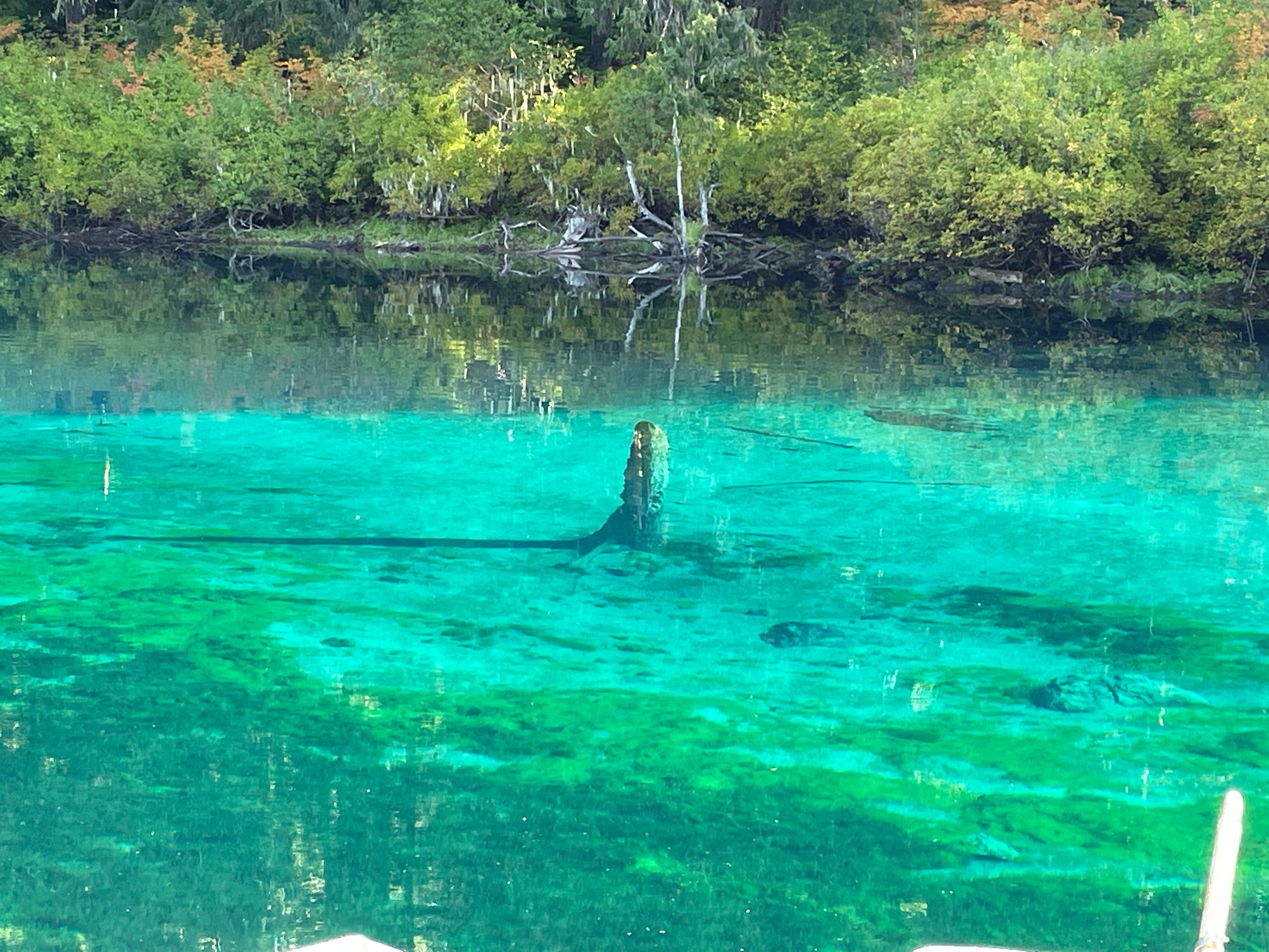
In recent geologic times, the upper McKenzie river was savaged by three separate lava flows that entered the McKenzie river valley and changed the course of the river. The first of these flows dammed the river creating a deep blue lake that is now called Clear Lake. At the bottom of clear lake, 100 feet down, dead trees can still be seen preserved throughout time by the extremely cold water. This same flow made the first of the waterfalls we will hike past today. The volcanic flow deposited a layer of basalt rock hundreds of feet thick and the river, when it finally won its way clear again, must flow off of that ledge to make its way to the Willamette valley.  The second flow did a similar thing up higher on the river and made the second of the falls we will see today.  The third flow created the lava that we hiked through yesterday and was so broken that the river, when not running at flood, flows through the broken rock underground to emerge once more at the Blue Pool, a sort of second start to the McKenzie river. 

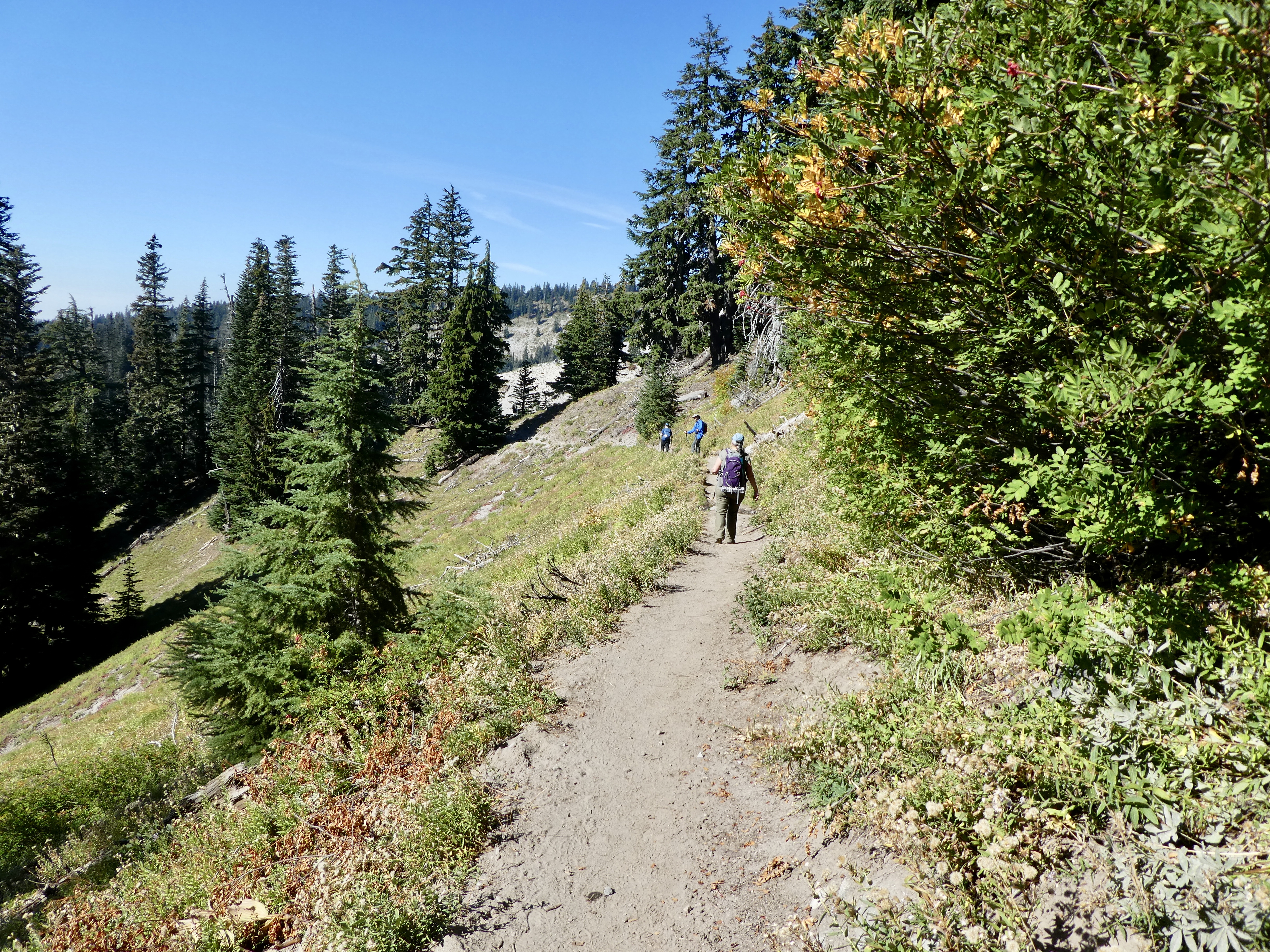
The loop we are going to do today can be joined at either of the viewpoints for the two big waterfalls. The East side of the river has a trail that has a lot casual observers walking a short ways from their cars. The West side of the river has a more difficult trail that is also the trail that is shared with the many bikers that ride down the McKensize River Trail. I am pretty sure that the bikers only ride down the trail…. Not back up. 

Today we are starting at the top fall (called  Sahalie) and hiking down past the second (Koosah). There is a bridge at the top and bottom of this stretch of river that allows for the loop around the area. This allows for good views of the falls, the many big cascades, and rapids from different points of view. 

If you do a lot of hiking, or even walking around, in Oregon, sooner or later you are going to have to decide if you are a fair weather hiker. Not just the ‘oh, it may rain today, I had better stay in’. If you do that you probably don’t even go outside except in the summer. The kind that says “Well, it is going to be raining pretty much all day and I had planned this hike, am I going?”. Today was sort of that second kind of persons day. Normally I would get around this by planning my activities a few days in advance and trying to steer around the weather. But today, we are in a quaint little cabin on the banks of Clear Lake and the rain is coming down in a constant drizzle so our choices are brave the rain or sit in the one room no WIFI, no TV, no Radio, No Telephone, no Water, cabin. Yes, that is what I meant by ‘quaint’. So we are going hiking. Good thing we have good rain gear. This means rain pants, a Gortex-like jacket, and water proof hiking boots. Also, it helps to have some warm half gloves or something like that. Rain in the fall can be cold. 

You know what the problem with hiking in Rain gear is? Heat. If you are going uphill or doing some semi difficult walking (like we are today) you generate some heat. On a cold day (like below 45) you may be able to stay at a reasonable temperature, but today is more like 55 and our rain gear makes for great insulation. You stand the risk of getting more water inside the gear from sweat and condensation than outside from the drizzle. Oh well. Dress in layers. Take time to remove inner layers when you get hot. Abandon the rain coat if the rain lets up for a while. Have dry clothes and a towel in the car. Have a blast. 

Have I got us out of the parking lot yet? No?


This is that natural canal thing.

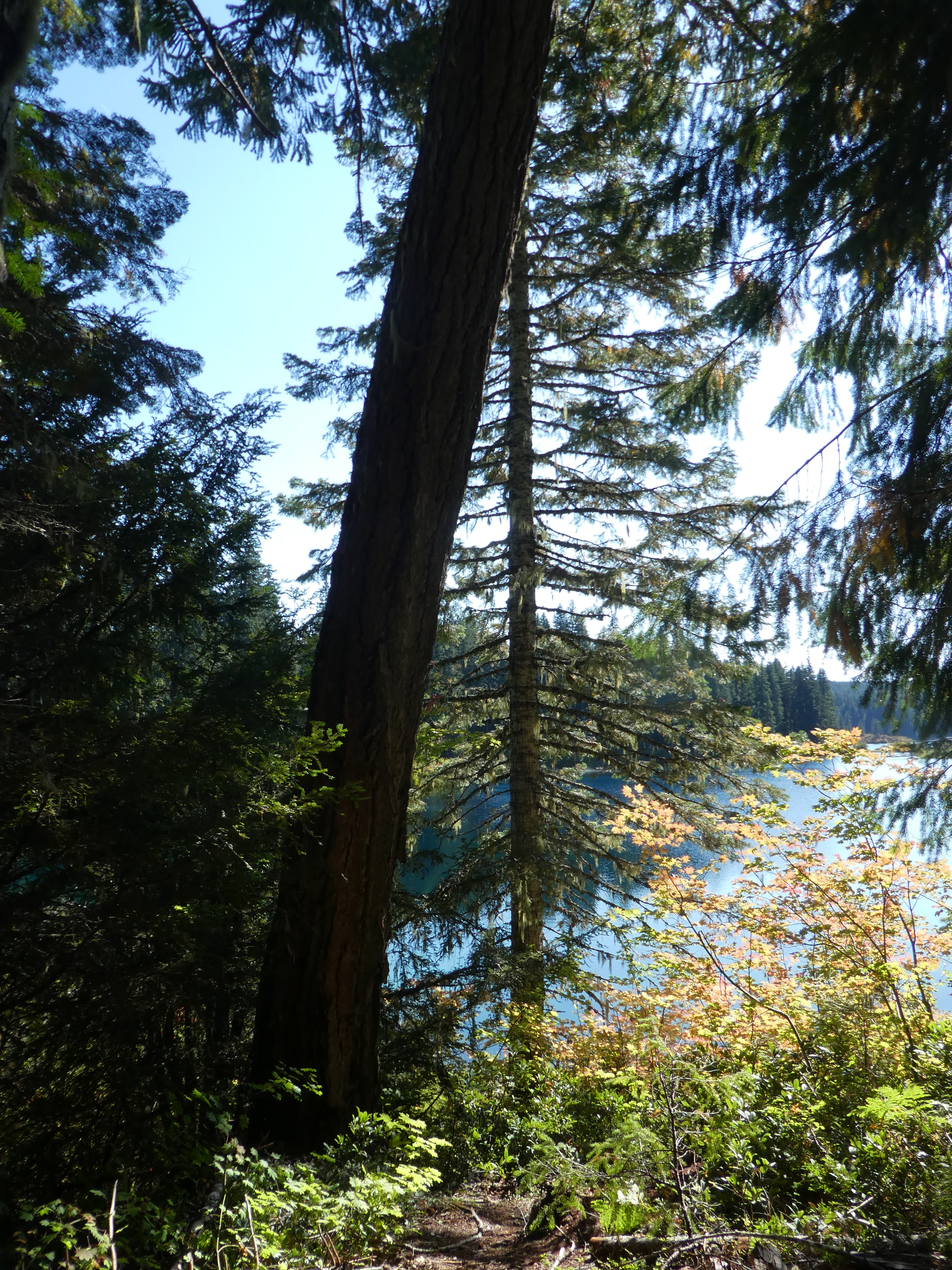
The river here is wild and cold. The lava rocks that the river is flowing over are still relatively young and sharp and there are a lot of strange formations that the river has to negotiate. For instance: At one point there is what appears to be a wall going out into the river. It makes a partial canal that cuts across the river and makes a nice little side flow. This is not man made, it is a lava edge sticking up into the river.  I took a lot of pictures which I include here but they really can’t do much justice to the majesty of this wild stretch of river. 


I would like to call attention to a couple aspects of the vegetation. The East side of the river is very wet. It was raining on us today, but it also seems like the spray generated by the falls and the many rapids make for a lusher and mossier than usual terrain here close to the river.  Then there are the plants growing in the river and on the rocks on the sides of the river. A short green moss or perhaps algae is on the banks, on the rocks, and growing deep into the river even under the fast moving water.  I will try and look up this plant name. Maybe I can find a Ranger that knows that it is.


We are hiking down the East side first and it ends at a road and a bridge across the river right at the first reservoir on the river. We are now hiking back up the river on the west side. The trail is much more challenging on this side. I know we are walking uphill, but there are also a lot more rocks and twists and turns and such.  We have to quickly go back up the cliff to the top of the fall and that accounts for some of it. I can’t imagine someone riding a bicycle down this stretch of trail, but I guess it is a pretty common thing to do. I am guessing that bicycles have changed somewhat since I was 12.  I do have a bike that I ride. But in the city or on easy flat paths. Nothing like this. 

This West side of the river is up on a higher cliff than the East side. This is the reverse of the situation of the section of the river further down near Blue Pool that we hiked yesterday. In many places the trail wanders close enough to the edge that side trails and impromptu viewing platforms have been made on the cliff edge. There are a number of great views of the river, rapids, and falls from up there. It is worth the little extra effort to walk off the trail a few feet for the sights. You are right on the cliffs though, so watch your step. If you were making a list of great places to commit suicide by jumping to your death, I would add this one. Not that I am making such a list, mind you. That would be crazy. Even to talk about it in a blog would be sort of strange. The sort of ramblings you might expect from a person that had spent a couple of nights in a quaint cabin in the woods with no running water or WIFI.  But I digress.


We hike up past the first fall and then to the up-river bridge. This is a new and strong foot bridge over the start of the wild part of the river. From there it is a right turn and a not to difficult return to the parking lot via the last viewing platform for Sahalie falls. I might add that at this point you will be offered a choice of hiking on the rock strewn trail along the top of the river gorge or a wide old dirt road that runs along parallel. Such an inviting pleasant wide flat path. Don’t fall for it. It runs out into the woods, makes you negotiate several old tree falls and then just ends at an old campsite. Dammit.

We did a little exploring of the area before we did the hike and I wanted to mention our side trip to a place called Fish Lake. There is a historic site there where there has been a stage coach station. A place to change horses on your wagon when making the run between the central valley and the Willamette valley. It is now a interpretive site and a NPS ranger base. 

Sahalie Falls from platform

Looking down river from Shale. Note the green

Fish Lake, at this time of year, is a big green meadow. It is in the middle of a big jumble of lava flow. In the winter and early Spring, when the local creek is flowing hard, the water can’t escape through the rock fast enough and a lake forms. The trout in the creek move into the lake. I assume there is good fishing there at that time and thus the name, though I can’t imagine  enough trout live in the creek to make it worthwhile for fishermen. As the rains stop and the creek flow slows, the water quickly drains out of the lake and the grass that was dormant underwater reasserts itself as  a meadow. The fish swim back to the mouth of the creek and stay up the creek for the summer.  This is not a unique situation, I know of at least one other lake, up in Washington, that has a similar life cycle. 

I really enjoy hiking through the lava country. Many unexpected and thought evoking sites to see. Might I suggest a few other stories about Lava areas: 

Lava Days

Hiking a Lava Tube

Mt. St. Helens Eruption Hike

Hike around a big Volcano Crater in the Galapagos