Monday, May 30, 2016

Galapagos Adventure: Vulcan Negra (Isabela Island Part 2)

Vulcan Negra (Sierra Negra Volcano)


This is our long, hard adventure of the trip. The hike is advertised as a “very strenuous” 10-12 miles with beautiful views of the second largest caldera in the world. My partner and I had done some prep hiking back in the states. The first description that we read said it was a five mile one way hike with a 1200 Meter Altitude gain. That is one tough hike. So we practiced on a place called “Dog Mountain” which is a 1000 meter altitude gain over around 4 miles. So comparable. It kicked our butts. Well, my butt. So I read more about the Vulcan Negra hike and found out that the mountain max height is 1200 meters, but you start at the local park headquarters at 800 meters. So you only have to hike up for 400 meters. over five miles. Hell, that is nothing!

I was a bit worried about water, however. We have been hoarding disposable 500ml plastic water bottles and now had 2 or 3 apiece. So we figured we could carry 2.5 liters of water each. We hoped that would be enough for us. But now I am worried about the rest of the people in the group. Or, to put it more precisely, I am worried that they are not worried. I talked to our guide, Fernando. Is he sure that people will have enough water? He says that he is going to carry water for people and they can fill up off of his supply. Now how is he going to carry enough water for 16 people on a hot day for 10 miles? I should have remembered that he has done this before.

When we woke up in the morning it was not quite cold in our luxuriously air conditioned room. The power had gone off around midnight and stayed off until right at 6:00 am. Not sure if this is a daily thing or what. Breakfast was in the hotel. I am really liking the morning granola and yogurt.

Our Chiva Bus met us out front right at 7:00, and we all crammed in and we were off.


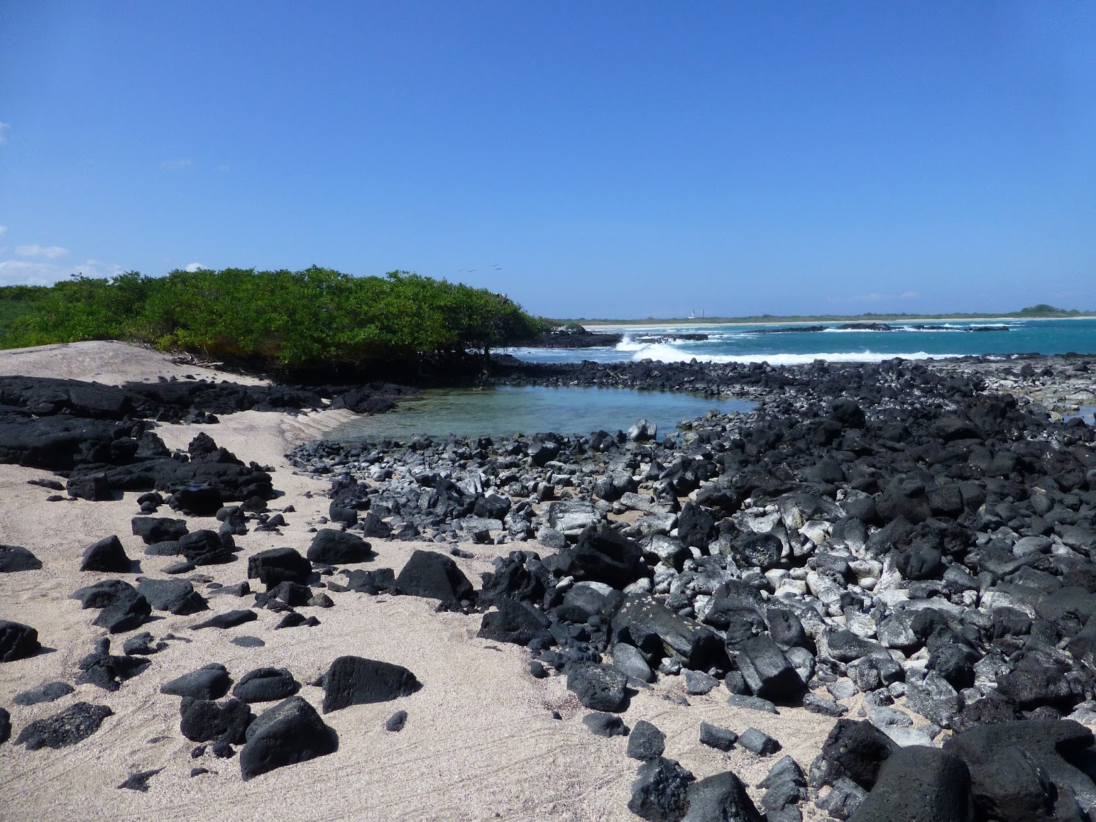
The little town were are in is only a couple of dirt roads and white brick buildings and it is all built on a large flat lava flow. As you leave the town you can see where people are plowing and filling the flow to make build able areas out on the outskirts of town so that new houses can be built. There is a new airport out there too. Certainly plenty of flat land for an airport.  Just Cactus and limited vegetation there now.

Morning Glory Monster 
When you start up into the highlands you meet your first island invader. Morning Glory vines have overgrown everything. It is a huge undulating mass of morning glory. Like the red weed from Orson Wells' "The War of the Worlds". As you continue to climb up the volcano you get to places of more and more water and you get more jungle like conditions. Lots of farms up here. Cows, horses, banana. Trumpet Flower. That must be invasive also. I think that everything with a flower is invasive. What pollinates the flower of an invasive plant anyway?

Trumpet Flower
It is pretty hot but as we continue to ascend we run into the cloud bank and things cool off. At the end of the road is a parking lot, a little picnic shelter to get out of the sun, and a building with the nicest bathrooms I have seen in 3 days. That was a surprise. This is where the hike starts. In fact, the hike is really a continuation of the road the has been blocked off to local travel. We climb off the Chiva, use the facilities, and start on our way.


Those trees.... the evil Guava
Pablo explains continental drift using local sustainable visual aids. Hey, is that my trekking pole?

We haven’t gone very far when Pablo stops us and gives us a long lecture on the geography of the islands. This area is where two tectonic plates meet and the resultant subduction pushes the molten layer close to the surface, where it then breaks through and forms volcanoes. The “hot spot” where the volcano forms stays approximately stationary, but the surround planes, and indeed the volcanoes themselves, are drifting slowly and steadily southeast. So, the further south you go in the archipelago, the older the islands are. Remember Floreana? It is a very old island. Its volcanoes have been weathered away and collapsed down to that central core. Isabella is a new and still active island. In fact, Isabella is really five volcanic islands that have grown together into one long wall of volcanic activity (and each Volcano has its own species of Giant Tortoise). The last eruption on Isabella was in the October 2005. Part of Vulcan Negra overflowed down the side to the sea in an area that we are going to hike today called Vulcan Chica (which means "little Volcanoes" or "children volcanoes").

As we continue our hike up to the rim of the caldera, we are shown our second invader. It is everywhere and I thought it was the Scalesia that is native to the area, but no, it is Guava. The guava is just everywhere. Every tree-like plant is a guava. Some are in the farmers farm. But everywhere else, they are growing wild.

The local birds (the Galapagos Finch) just love the guava. They eat the ripe fruit and then pass the seeds far and wide. The plant is threatening the local environment as it squeezes out the local plants and sucks up all of the water. I guess the government is trying to control it, would like to eradicate it, but how to do that?

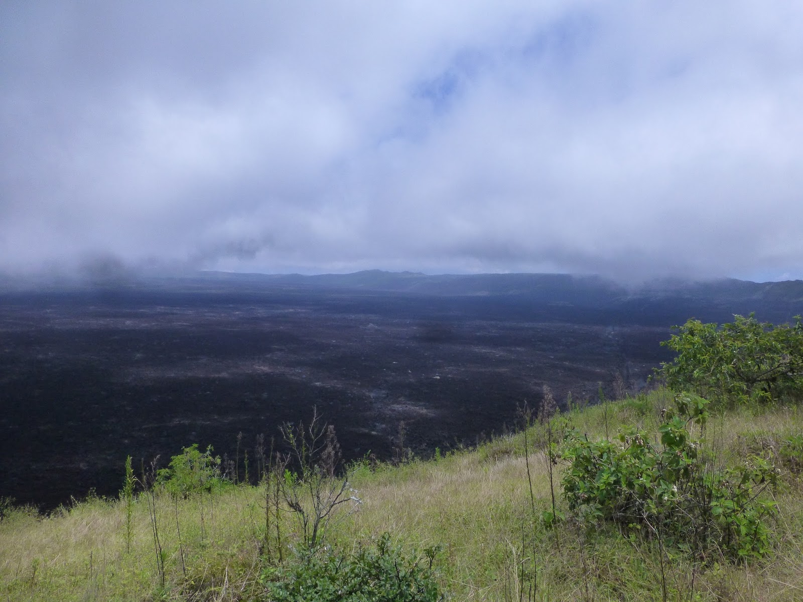
I was pretty worried about heat and water and this hike. But we had low clouds and moist cool air blowing on us and shielding us from the heat. That was good, except that the mist was also blocking our first view of the caldera, when we finally got to the rim. But oh my, what a view even with the clouds. The inside of the volcano is filled with a sea of black rock. Does that explain the name Sierra Negra?

A vast sea. I include pictures.


A likely Overlook


The next few miles of the hike is around the rim. This part of the hike is very easy, in fact the entire hike up to the Vulcan Chico side trail is on a jeep track. We even ran into a ranger truck out on the rim.

Lots of picturesque side places and we picked one for lunch.  (Editor's note: Some folks decided this was a great day hike and turned back at this point.  Not us.  Later we would look back on this trip and wonder why there wasn't any down time.  I mean, it wasn't at all like a vacation, in that we came home exhausted from all our adventures.  In retrospect, we discovered that we said "yes" to every little side adventure, and thus eliminated any rest and rejuvenation time.  A interesting discovery on our personalities.  I wonder if we'll get better at balancing adventure and rest?)

Then comes the more challenging side trek. You hike down the outside of the volcano for a few hundred meters until you come to the place where the most recent eruption (in 2005) broke through the caldera wall and came running down onto the plane.

We hike across sharp lava and frozen rock flows. You can see where the brown lava meets the black lava. There is a lot of iron in the lava, so as it ages out in the air, it rusts and turns reddish brown. The new lava flow is still black.

Feel the Heat?

This is just one weapon-like cinder. The group is covered with them
First you find the frozen cinders that were blown out on top of the old brown lava. These little cinders (millions of them, mind) are like miniature spear heads. You aren't allowed to bring anything home with you (not even a little tiny stone...) but I did take a picture.  After the cinders you find the frozen river of black that flows through the center of this little offshoot hike. Many lava tubes. Most of them just a few feet across, but a few big holes and possible tunnels that are tens of feet wide. Our guide, William, showed us a hole in the rock where you could feel the heat coming out. He said when it rains that steam comes out of that hole. From another hole we could smell sulfur.
 

Little Lava Tube
That is a lava tunnel. I think

My Partner looks down into a fissure.


This is the new flow out on top of the old flow. My colors are not so great here. I remember the new flow as being black

We had hiked over to the south side of the volcano. This meant we were now on the dry hot sunny side. So even if we were not out walking on highly reflective volcanic rock, we still would have been in the hot sun on a now cloudless day.

Our tour coordinator, Fernando, was along with us. In each hand he was carrying a 5 liter bottle of water, for people to refill their personal bottles. My Partner and I had each brought along 2.5 liters in various containers. We were very surprized that people were not carrying their own water and felt pretty sorry for Fernando lugging that water around by hand. I admit that I filled my personal bottle a few times from his supply instead of getting the water out of my pack just to try and make his load lighter.
A vent with life growing. I am betting that steam or
very moist hot air comes out of the vent after a rain

That is a flow, not a highway

That is a lava tube. on this part the top collapsed,
but in some parts you could crawl inside.
Fernando is carrying our water

Not much life out on the lava. But still a few things are trying. Inside some of the deep looking vents, around the edgs and mostly out of the sun, there were  ferns growing. I figure the hot air coming out of the vents must have a lot of moisture, perhaps a lot of it is steam from rain runoff into the lava.


A plant island in a sea of old Lava

The hike back out was a bit harder than the hike in. I actually think that going up hill is usually easier than going down hill, Well, steep uphill can be less slippery than steep downhill, anyway. But today, we were doing this last 400 meter ascent after already hiking 5 or 6 miles. So we were very happy to get back up to the rim of the caldera.

Things to do: look up difference between caldera and crater.
William and I had a little disagreement as to the difference of a Crater or a Caldera. I maintained that a crater was formed from an impact or explosion; like a meteor strike.  And that a Caldera was the inside of a volcano. William disagreed and said a Caldera was a kind of crater formed by a collapse of a Volcano.

The internet says: A crater is formed by sinking of the top of the volcano as lava weakens the rocks. On the other hand, a caldera is formed when the overlying rocks collapse to fill an emptied huge chamber of magma.

When I read this definition I think that the definition says a caldera and a crater are the same thing. But, it is on the internet so it must be true.

And all of this time, Fernando is still carrying water for everyone. He started out with two 5 liter bottles, one swinging from each arm. Now, I consider myself to be something of a scientist. I use metric quite often in my daily work-life. So please bear with me now as I ask "How much does 5 liters of water weigh?" See, this is little funny, because metric is defined around water. So a liter of water is a kilogram. So 5 liters if 5 kilograms. Now, if I just knew how much a kilogram weighed.....

The other thing that happened when we got back up to the rim was the mists had blown away and we had an unobstructed view of the entire caldera. or perhaps, the Crater.  Oh my. What an expanse of black lava. What an absolutely cool place to build a secret space ship launching station. Or perhaps just a cable car ride down the steep sided cliffs to the lava below. I am sure if you built it they would come.
This thing is SO HUGE


The last few miles are quite the slug. Hot, humid. Drink your water and keep walking.

We got home just in time to buy a bag of Hielo ($1.50 for a very small bag) and ice our very sore knees before dinner.

I think that is the store with Ice, on the left


Our Hotel


Saturday, May 21, 2016

The Galapagos: Isabella Island, Part 1

The Galapagos: Isabella Island, Part 1


We got up early in the morning. We were supposed to have our big luggage out in front of our cabins before we went to breakfast so that it could be carted out to the “speed boat”. My partner and I saw Claudio and our guides carrying the luggage, and you know what? That just isn’t quite right. So we lugged our luggage (oh my God, that is why they call it Luggage!!) down the boardwalk to the waiting truck.  (Editor's note: Actually, I started down the boardwalk and two of our guides came hurrying down to carry my medium roller bag for me.  It's very hard to be a strong, capable, competent woman traveler on a trip like this.  I learned to stop arguing and let them carry my bag on day 2.)  Then we went to a very nice standard breakfast.


We walked through town instead of taking the bus just for one last look around. We had never walked past the Widmer property (from land) before. They have a sign and everything. Down by the landing, we had to stand in line for agriculture inspection. Once again there was a little booth and a nice woman who looked through our bags to see if we had seeds or shells or live animals. I guess they had done the same thing with our big bags and then carted them on the water taxi out to our speed boat. Nice. Now it was our turn. You know, putting 18 people on these little water taxis is a bit of a hoot. You have to control yourself. Don’t stand up. Don’t everyone lean to one side. As you board, make sure that you alternate sides of the boat so you don’t unbalance it. The hard part is getting off. You need to stay seated. Don’t everyone stand up like you are getting off a plane. Stay seated and wait for the person(s) in front of you to get off the boat.

And then we are on the Speed Boat. And off we go.

Once again we were blessed with relatively calm and flat seas. So we moved right along. Not much to see on these rides. When we were most of the way to Isabella, we passed a small island called Tortuga (turtle). All of the little islands around the Galapagos seem to be these collapsed Volcanos. So they are the circular uprisings with one side missing; a sort of moon shaped thing with very steep sides. This one has another little island off of one side such that if you view it from Isabella, it looks very much like a turtle (and a little head).


This guy followed us everywhere. He is so serious

Isabella is an adorable little harbor.  Very protected and very crystal blue water.  There were a lot of big boats in the harbor.  Well, not huge, but boats that could accommodate 16 or so passengers/divers.  Trimarans, Power boats, Three Masters, all sorts of boats.  It turns out that there is a large tour business in the Galapagos that involves very little time on land. Little cruise ships that travel around the islands for water adventures.  A friend of mine did one of those, and she had a very different sort of experience.  They went to some of the more remote islands.  That might be something we would try if we ever do round two.

Our speed boat drops anchor and we quickly have a water taxi pull up and take us over to the commercial dock. Lots of water taxis and dive boats and the like here. It turns out that the Galapagos used to have a big problem with Illegal Fishing. I am guessing that it was old family boats and legal fishing at first but as the eco laws came into being the traditional family businesses became illegal. Now what do you do? Well, the Ecuadorian government was smart about it. To stop the illegal fishing without putting their entire population in jail, they invested in the fishermen. They gave them money and training and let them all convert their boats/business into water taxis and dive boats and tour boats and such. What a great idea.

Back at the dock, it is time for us to catch the local chiva bus and head to our hotel. We walk up the road past a nice sand beach. There are lots of sea lions hanging around. The bus takes us into town. There is this over the top nice paved road that goes the half mile into town. Really nice pretty road. With a big “Welcome to Isabella” archway you have to drive under. The chiva bus just barely fits. You drive down this nice divided road past storm beached boats and little beach cottages until you get to the town proper. Then the road turns to dirt. Strange.

The beach in front of our Hotel


Our hotel is just off the main road right on the beach. What a nice hotel, The Albemarle. The Albemarle is a two story white building built around a little pool and hot tub (that has been turned into a terrarium). Our room was right off to the lobby and it HAS AIR CONDITIONING.
It was positively cool. And we had two full beds. We seem to be having a hard time communicating to our tour group that we are effectively newlyweds and that a large bed would be appreciated. But…. we have AC. And a very large and wonderful bathroom with a terrific shower. But no desk. I guess they don’t expect people to be working much here. I found the remote for the AC and cranked it down to 18. Ah, I am getting used to Metric.

We made such good travel time that we were in our rooms before lunch. This means that we have an afternoon of adventure planned. Let me check the schedule… hmmmm. Nature park. Walk to the crying wall. (Iguana) Love Beach. And then kayaking. Wow.

Off we go down the beach road in our chiva bus. We are going to the local estuary park.

Here is the map of the estuary area. Notice the Pink.


Now, an estuary is a place where fresh water meets salt water. But as we have discussed, there isn’t much fresh water in view, at least on the surface, around the Galapagos. At the estuary (El Estero) there are a number of lava side ponds and seepages. I think that fresh water is seeping through the lava flows from the highlands and leaking out down here. The geography shows that this section is surrounded by other lava flows and it is possible that this is channeling the fresh water. On the other hand, we also have saltwater seeping into these same lava ponds and formations. Right next to the estuary, closer to the town, are some natural sinks and some that were manmade (holes excavated for building materials) and these holes have only saltwater leaking in. In these areas, the water is evaporating, which causes a rise in salinity of the water. What happens when the salinity gets high? It creates the perfect environment for Sea Monkeys!! That’s right, those clever little acrobatic mites that you raised in a cup of saltwater on our desk at home when you were eight. You remember those guys, right? You ordered them with a coupon you got out of “Amazing Spiderman #6”. That’s the issue where Spiderman has been beset by Dr. Octopus, but Daredevil has come to his aid and….. or perhaps I digress. Anyway, Sea Monkeys are also called Brine Shrimp. You can tell their presence (at least in high concentrations) because they turn the ponds pink or red. These same shrimp are a favorite food of the local Flamingo, and you know what? They turn them pink or red also.  But I don’t actually find that out until the day after tomorrow, so perhaps I am getting a little ahead of myself. Right now we are on our way in the Chiva Bus to the nice conservation park wherein lies El Estero.

You used to be able to drive all the way out to the Wall of Tears but they made the last few miles bike and walk only. So much nicer. The Wall of Tears was supposed to be our final destination, but our guides said “Look, it is just this wall of rocks that some poor prisoners were forced to make out in the middle of nowhere. Not very interesting and a long, hot walk. Wouldn’t you rather spend your time seeing more birds and local flora?” I think that we were somehow out of time or had a scheduling issue later with the kayaks, but I certainly couldn’t fault his logic on account of my knee hurt. And it was HOT.


The shoreline from the town to el Estero is all very pretty white sand beach. But right where the road ends the beach turns to lava rock and Mangrove. The Mangrove stretches everywhere out here by the ocean (all 4 species are in this area) and many of the little side trails snake like tunnels through the interlocking roots and branches. Be careful where you step, lots of loose sharp rocks and some of those loose sharp rocks are Marine Iguana. We first stopped at a nice beach to look around. The Pelicans are in view. They are nesting in the tops of the Mangrove. Further down the main path, we have to get our feet wet on the actual estuary trail. It seems that at high tide there can be several inches of water along the entire path, but right now, we can just barely negotiate it without getting too damp. Oh, was that a cactus? What is that doing here? Out in the actual “Estuary” we can see a little bay of bright blue water that seems to reach inland, like it was meeting an outgoing stream. Except I don’t think there actually is any outgoing stream.

Is that Fresh Water? Brackish? Certainly not much water on top of the lava

The big attraction here is the birds. What do we have?
Lava Gull and Pelican of course. There, out on that little rock of an island, 100 yards off our shore, is a flock of the famous Blue Footed Boobie! They take off and fly around and then all of them nose over and dive in. Unlike Pelicans, when they dive in they stay underwater for awhile. Then they pop up. Often they have a fish in their bill, which they then toss up and swallow. There are the Frigate birds nosing around. Looking for a chance to steal a fish. And there off to the left are some sea lions and a little group of Penguins!!

Boobies

Pelicans

Lava Gull


Boogie Plunge

Penguin

The Penguins are so cute. They don’t get real close to us this time, but we will see them better from the kayaks later this afternoon.


One more stop before that, La Playa Del Amor. Love Beach. Now, I don't know about you, but I was thinking something along the lines of big white sand beach, a few palm trees, and clothing optional. What we got was sharp lava rock, no trees, and lots of signs up prohibiting our passing on account of the Marine Iguana nesting sites. This is a love beach for Marine Iguanas. Just so. Lots of the little buggers around. If you get too close to them (like, to take a little picture) they might spit at you. Don't take it personally. They have these glands that secrete salt to help them get the salt out of their system and they have to explosively expel it every once in a while. And if they choose to do it when you are in their face, then they spit salt at you.


Ok, so this is a Lava Lizard


The little pool in the mid-ground is the "love pool". Our guide said it was "couples only". This may have been a joke.

Hey, look at the time.  We need to go go go! Back down the trail to the waiting chiva bus. Ah….. What waiting Chiva Bus? Dang. Well, good thing that cell phones work on this island. We just call for backup. And how far away can it be, anyway? The town is only 5 minutes away and 2 minutes wide.

I would like to warn you that the chiva buses on Isabella are not as solid and safe as the one (ha, one) on Floreana. I put a outsticking screw into my palm getting off the thing at the estuary and we had a seat collapse at one time on another ride. So, watch out.

Still it got us back to the landing beach where we were going to get in our kayaks and go out and explore the bay. This is the same bay where we had originally come in on our speedboat (which I think is right over there waiting for us). There are some nice little wood benches to sit on and enjoy the beach. But these benches are full of sea lions. Now, sea lions are very interesting and sort of cute (especially the small ones) but they are also pretty stinky. You certainly don’t want to sit on a bench that one has recently vacated. But they bark out and walk down the beach to the water and are generally benign. Still, they are wild animals and have big teeth, so treat them with some respect and distance, at least on land. I sort of feel that if they come up to you in the water, they are more in their element and not yours and so would feel less threatened. (When we came back from our hot little hike on this islet I was going to sit on this bench so Jon could take my picture with the sea lion, but another one had moved in- no bench for me, just two sea lions lounging!)


See, that black shape is a manta-ray. No. Wait, that is my paddle. 

We got put into some kayaks. My partner and I made sure we got one of the bigger ones as we had overloaded the last one we had. If you are low in the water on a self bailing boat, it becomes a self filling boat, don’t you know. The bay is very protected. Down at the end of the bay, the water is clear and blue and maybe 3 meters deep. It is mostly a sandy bottom but we saw a few big black rocks on the bottom. Hey, that big black rock is moving. “Manta Ray, Manta Ray” sings out Pablo. Ah. We paddle after them. But black flying shapes down there on the bottom. Wish I had my snorkel gear. I should have thought to stick my waterproof camera over the side and take an underwater picture. Around the curve of the bottom of the harbor we go. The part that is nearest (and indeed sloshed on) by the ocean. This area is a little low lying stretch of AhAh lava (so called because that is the noise you make when you step on the razor sharp edges) that we are going to visit for a little nature hike in 2 days. Right now… we have the penguins. We run into a flock (school? Herd? Congregation?) of the little guys. They dive off of the rocks and come flying toward us. Now, they are really swimming, but I say flying because they are using their vestigial wings to propel themselves through the water rather than their flipper feet. It looks so cool. When they quit moving their wings, they bob right to the surface, they are very buoyant. Probably like wearing a wetsuit, if you aren’t fighting to stay under, you float right to the top. We had a couple come over and fly right under our kayak. So fun.


A hundred feet further on and we came to a favorite hangout for the blue foot boobie. Here we got to see this interesting looking birds pretty close up. They were up on the lava right next to the water. There were buoys set out, and you weren’t supposed to come any closer to the rocks than those buoys. But… our guide sort of forgot to tell us that so we may have strayed little close. There are a lot of rules like that out on the Galapagos. The guides are very sincere and industrious about enforcing them, but if you screw up there doesn’t seem to be any enforcing authority. Perhaps they were watching us from there secret eco enforcement submarine. They look like manta rays from the surface, don’t you know.

Pablo "Explains to us Very Well" 

Sally Lightfoot Crabs

We paddled around the little barrier islands. Some have big stands of Mangrove. The wind and waves were blowing up a little bit, so we didn’t head out into the ocean much. Then we started back across the wide part of the bay to our beach.

As I believe I had mentioned, these kayaks were a little bigger and nicer than the ones we had at Floreana. They have cloth seat backs, for one, that let you lean back and relax a little. I still was a bit tight in them. You know, back in the USA in our paddle club (Kayak Portland) we call these 2 person boats “divorce boats” and I can now see why. My partner and I are very loving, but we are also very independent and we both know how to make the boat do what we want it to do sort of without thinking about it. So if she wanted to go one way (or just thought we were going that way) and I was thinking another way, we would both be making little strokes with our paddles to steer in opposite directions.

On the other hand, when we both thought we were going in the same direction, then we paddled well and strong together and were doing just fine.

But we were going in the opposite direction just enough that we were getting a little frustrated with each other. My recommendation is that you either switch front and back positions on different trips or you have the person in the front that doesn’t care so much where you are going. Or even better, get each of you your own matching boats with your names on them. I want the red one.

Back in the chiva and back down the nice stretch of road to our very nice Air Conditioned room. Dinner at 7:00.
The street right behind our hotel is lined with little restaurants. They all appear to be approximately identical with essentially outside dining of Wahoo, Pizza, Burgers, and Plantains. We had a wonderful group dinner.

Tomorrow, we hike Vulcan Negra.