Sunday, February 27, 2022

Astoria Riverwalk


My partner and I had originally planned on spending this weekend Yurt camping out at Camp Stephens State Park. But the weather forecast wasn't good. They don't allow cooking inside the Yurt and what fun is sitting in a Yurt all weekend if it is too wet to go out walking? So we switched things up. We went a day earlier and stayed in a nice Hotel in Astoria instead. This turned out to be very wise because a big storm was coming in on day 2 (that would have been day 1 in the yurt). 


So here I sit in the lobby of our hotel, looking out the rain speckled window at the scudding clouds blowing up the Columbia River. Very grey, but with an certain attractive aesthetic. We spent a few hours this morning walking the entire 4 miles (and back) of the Riverwalk. The trail follows the river (duh) and the old train tracks that come up from Portland and end at the Lewis river at the far end of Astoria. Our Hotel (The Hampton Inn) is at the East end of Astoria and so at the East end of the Riverwalk (and the East Terminus of the Astoria Trolley, when it is running). 

The Riverwalk is somewhat reflective of the feel of Astoria, in general. There are nice recently upgraded sections, with new electric lights and green grass and such, and old dilapidated sections that cause you look around and make sure you aren't being followed by unsavory characters.  The East side, where we started, is a nice upscale section. Right next to our hotel is a road that runs out over the water to a historic pier that now houses some airBnb rooms, a kayak and Scuba business, and a Rogue Brewery public house (the first in our tour of Breweries on this walk). 

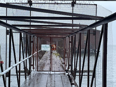
As soon as you get out in front of our hotel you can hear one of the local 'attractions'. There is a colony of Sea Lions that have taken over (and pretty much sunk and destroyed) a floating dock out in the East Boat basin. Last time my partner and I were here we walked out the wharf to see them and take a general look at the boats and such out there. At that time people could walk out on the pier and fish and gawk. But today the pier was closed to all traffic due to structural damage. Sad. 

Welcome to the Hotel California...

Barricade to old Pier to Sea Lions


Right at the base of the pier, however, was a large tree with 3 large birds in it. We gave them a good gander and decided that they must be juvenile Bald Eagles. They were really big. They just sat up there and gawked at us gawking at them. 

This part of the trail is right on the jumbled stone built-up shore of the Columbia. It was high tide and in some places the ocean was lapping just feet away from where we walked. We waved to people in their hotel windows and enjoyed the view. Out in the distance, I could see where the Columbia dumps into the Pacific, with the expanse of the Astoria-Megler bridge gracefully spanning the gap between headlands. As I watched, the entire vista disappeared. Wow, I thought, look at the fog blowing in. Turned out it wasn't fog so much as a rain squall coming in from the Ocean. The first in a string of them to visit with us during our 3 hour walk.  

Down on the East side of Astoria are a lot of rather large and very old houses. These houses are all over Astoria, but down here they are more rundown. They are the old mixed with the new. The new are a community of new built houses around the old Mill pond.  The new houses are so new that they don't show up yet on Google Maps or Zillow. It is a pleasant looking community, probably for rich retirees from Portland.  They don't really give any access to the water, however. No floating docks on the pond. 

Old

New

Newest

Right about now that Squall hit us and we had to zip up tight and start getting wet. Right away I ran into the problem that it was getting hard to take pictures with my iPhone. Why? Because with my hood up Siri could not recognize me to automatically unlock my phone.  It was also getting a little hard to see things because the blowing rain was be-speckling my glasses. After a few minutes the rain stopped and I put my hood back down. But Siri still couldn't recognize me. It must be the water drops all over my glasses !! Siri is no doubt using a facial recognition algorithm that is somewhat different from the one we humans use and that is why she had trouble recognizing me in different looking glasses. 

Hey! This must be why Clark Kent wears glasses as a disguise. Kal-el (AKA Superman) isn't a human. He doesn't have the same evolutionary history as humans and no doubt his species facial recognition works differently than ours. His people are all so perfect, they probably never wore glasses. I bet when he puts on his Clark Kent glasses, he can't even recognize himself in the mirror, so he never even considered that humans would be able to recognize him.  Silly super being. 


Here is the Astoria Train Station. It was a big deal back in the early 1900's when Portlanders would ride the train down the Columbia to visit Astoria or the beach town of Seaside. There were a couple of passenger trains and freight trains a Day up and down the river in its heyday. Before the roads got better and cars got more popular. Now the building is part of a maritime museum of some sort and sits right next to the parking lot for the big (and impressive) Columbia River Maritime Museum. You can't miss it, it has a huge beautiful Pilot boat out in the parking lot. Inside is pretty cool also, the Museum is sort of built around a Coast Guard rescue boat that is mounted on a steep angle of a huge plastic wave. You can see it from the front window. 


Now we get to the downtown part of our tour. This area has gone through a number of transformations over the years as it has hosted different industries. It used to be lumber, and then sardines, and then other fish. I think the expensive big old houses with the nice views up the hill attest to different fortunes that were won and lost over the decades. The new industry for the town is Nostalgia (tourism) and Beer (Beer).  I already mentioned that we started this walk out in front of the Rogue Public house. Rogue is a relatively old and well established brewery in Oregon. They are the makers of Dead Guy IPA amongst other favorites. They have had this place out on the pier for at least a decade. The other breweries we now see down on the water front are much newer, but they all have wonderful beers.  One after the other we hit the brewing facilities of Astoria Brewing, Buoy, and Fort George.  I had a Buoy IPA with my Fish and Chips last night. It was really great and I would say that that was because it came out of the keg just a block away from where it went in except for the fact that the Fish place served it to me as a really cold mug and the just opened Can. The same can, presumably, that you can get in just about any Costco in the area. But it was Good.  Fort George makes the Vortex IPA, which I have tried and is also yummy. I don't think I have had an Astoria brew. I am going to have to fix that in the near future. As a matter of fairness, don't you know. 


This same area is right by the downtown shopping district. It is a quaint area of old buildings and old and new (but local) shops. A fun place to walk around in the summer when it isn't so Fraking Wet and blowing.  We are still following the trolley tracks and now things get a little crowded. Everything (the buildings and the street and all) are up on wharves over the river. Everything is huge pilings and wooden beams. Lots of restaurants, condos, and hotels built out over the water.  There are a few places where the trolley tracks (that are using the old railroad tracks) go around a corner over the water on a narrow train trestle  that forces pedestrians to share the same space as the trolley. If the trolley were running you have to be very careful in this area. The Trolley is not running, not sure if this is because it is winter or because it is a pandemic. 


Lots of little Trolley stops along the line
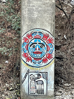
No Idea 

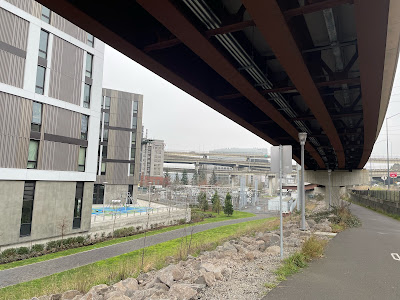
Now we get to a cool part. We get to walk under the bridge that has been looming in the horizon all of the time (that it isn't raining). There is a artfully down Maritime Memorial park just under the bridge. 


We are just about to the 3.5 mile mark and I must admit that my legs are telling me that it must be time to turn around and head home. My partner, however, assures me that just ahead the trail turns out onto that last of the piers and we will get a nice walk out to a nice view of the nice river. Nice.  Except for the stinging rain striking me in the face and soaking through my pants so I feel like I peed myself.  Good thing I was born adventure-ready. 

The Pier turns out to be sort of a historic reference. Nowadays it is more of a landfill. However, it is right at the border of Astoria where it runs into the confluence of the Columbia and the Lewis. And the wind was blowing. The Small Craft Warning flag was flying from the basin flagpole and the wind was whipping up white caps on the huge flat bay. Beautiful. Overhead, one the large Orange Coast Guard helicopters flew heading out who knows where, probably to help some guy that doesn't know what a small craft warning flag looks like (Red Triangle). We hit the end of the trail just as the rain peaked and the wind howled and I really did have stinging drops smashing into my face. Wow. I sure have a good raincoat. An important thing to have in Oregon. Wish I had worn my rain pants too. 

We turned the corner off the pier and back into town and the wind stopped and the rain stopped and... and... it was sort of nice. Gave me a chance to look at the big boats that they had up on stilts over on the old landfill pier. What is up with that? This one big boat (see picture) must have been sitting up there for decades. It certainly wasn't ever going to float. Why was it still there? Is it really cheaper to leave a derelict like that standing in your town? Might say the same thing for the useless (and probably immovable ) train cars that were sitting on the siding tracks right outside of the Astoria Trolley warehouse. At least the warehouse was a nice building and we could see the trolly sitting nice and secure inside. Probably getting good maintenance from the volunteers. If I lived in Astoria, I would certainly be a Trolley guy volunteer. Maybe they would let me drive the Trolley after a few years !!


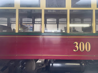
Trolley Through the Building Window


Well, keep walking back. The Eagles are gone, but the Sea Lions are still make a ruckus out on their floating dock. I don't think they ever get tired of that. Our hotel has a sign up that says that if you get tired of the incessant "Music" of our sea lion neighbors then they will provide you with your very own set of Ear Plugs. 


Oh, and the answer to the riddle "how is it better to go walking in the cold rain all day in Astoria as opposed to our original plan to go walking in the rain all day at Fort Stephens?" Well. Mainly. The nice hotel room and the hot shower.


Thursday, February 17, 2022

SpringWater Trail to 405 Trail - Cycling

A cleared camp

There is a (mostly?) off road set of bike/pedestrian trails that go around a big part of Portland. The total trip is over 50 miles, and I am not quite up for that yet (probably need another battery for my eBike). In the meantime, I am trying to drive some of these paths in sections. Had some nice weather last week so I thought I would try to get out to the 405 (interstate) trail and see what it was like. As it happens, it intersects with the Spring Water Trail near Clackamas Town Center, so I thought I would give that route a try. 

I started out at Sellwood park. It is a good central location and doesn't have a parking fee. It is usually pretty empty on a work day (in the winter). Last time I road along the Spring Water Corridor I was surprised by the number of homeless encampments. The first one that I hit (last summer) was actually a encampment disaster. A set of large tents (a least 3) and all of the accompaniment of stuff that had been set up under the Sellwood bridge had burned to the ground. Just a large smelly burnt area. This time, when I went through, that area was once again occupied with a number of large tents. It looked like someone (I am assuming the City) had cleaned up the burned trash and such. 

Today, as I traveled further down the Springwater, it seemed like their were many fewer encampments than my last check. Many of the zones where there were a lot of camps were now empty and cleaned up. They looked rather desolate. Most of the trash was gone, though there was still a lot of debris. Once again I am assuming that the city came in the forced the campers to move and then collected all of the trash. There were also signs of tree and brush removal, so perhaps the city used this as a pretext. 

The Spring Water is an old railway right of way, which means it is essentially flat and about 30 feet wide (the actual trail is around 8 feet wide). After around 5 miles I came to the intersection of the Springwater with the 405 trail. As you might expect, the 405 trail is a walking/pedestrian trail that extends along the west side of the 405 as it loops around Portland. It heads North/South while the Springwater is heading East/West. A bit further East along the Springwater is another North/South trail that takes you over to the Columbia at Troutdale. This is the trail you would take if you were doing the 50 mile full city loop I mentioned earlier.  

So I got onto the 405 and I immediately started seeing even more signs of moved camps. The 405 trail is NOT an old railroad. It is not as wide and has lots of little intersections with other walking paths and roads. It also rises up to intersect with the local light rail platforms from time to time.  As I said, I am again seeing the cleared areas. I guess they are a bit more evident here because they are occurring on grassy areas along the trail. So you have these square tent sized dead grass area here and there as you move along. 

There was one large area, perhaps big enough to put a small house, that was completely wiped. It looked like there had been a big encampment there and it had been moved and the area cleaned. But cleaned is really not a very good term. There was still broken glass and small pieces of trash and the area had thant burned plastic smell that you get after a house fire. This surely wasn't an area that the neighborhood could repurpose. You couldn't just plant grass and let you kids play there. It was now a Dead Zone in the neighborhood until someone could pony up the bucks to completely reface it. This is a bad thing. This is showing that the cost of homelessness (which is now being referred to as houselessness) is incurred by everyone. Makes the problem even more essential to solve. 


I was wondering where all of the homeless people had gone but as I peddled further down the 405 trail, I found them. They were packed tightly along the trail at discrete intervals. I think they were tending to clump at short walking distances from major street intersections with the 405 trail.  When I was riding, on a Tuesday late morning, there were not very many actual campers around. They were presumably out seeking food and money. 

One encampment that I saw was right across the street from a rather nice new set of first time buyer single family homes. These were nice looking homes, but probably starting out on the less expensive side because they were just across the road from the embankment going up to an interstate. But now those startup families had drug users and crazy people camped in the nice little grass area where I am sure that they envisioned there children playing. 

As I was driving through, I saw a young couple walking across the street from the tents to the nice houses. These two were dressed nicely, like they were going to work , perhaps as waiters. At first I thought they were residents of one of the houses and had perhaps been giving a meal or something to someone in the tents. But then I saw them wash their hands in the water tap of one of the homes and then move along, presumably to work. So here are people who are trying. But at the same time, they are going onto private property and using someones water.  The other thing that I saw in some neighborhood areas was vehicles that were being used as campsites. Often these vehicles were up on blocks and had their tires removed and perhaps windows broken. But there was evidence of people sleeping in them.


This is a section of nice homes that had no encampment across the street.
I think this section of the 405 embankment was too steep for tents.
this is how the entire trail should look

I came to one part of the trail where it rose up off the ground to meet pass over a large main street. The trail now sort of hugged the 405 overpass over the same street. This made a little sheltered area under the freeway and there was a long encampment here and trash was overflowing everywhere. The path was so chocked with debris that I had to slow down and wind my way through the trash and the occasional camper. In general, the campers were polite and would make way, in this area, however,  they tended to be sort of unaware of my passage and I had to dodge around them. I am assuming drug use. 

Perhaps a list of what sorts of trash you see:

  • Tents and tent components. Broken Tent poles etc.
  • Water bottles (large and small)
  • Clothing
  • broken bicycles
  • Grocery Carts (on a 5 mile stretch I counted 100 grocery carts)
  • Food wrappers and containers, especially from fast food joints.
  • Car tires
  • mattresses
  • camping chairs
  • tarps
  • propane bottles

One thing I do wonder about, where is all of the shit? I mean, there are no sanitary facilities anywhere along here and there is evidence of hundreds of people here. Where do they go? I don't think they just dump it locally because it really didn't smell like that. The overwhelming smell, when there was one, was of burnt rubber, plastic, and trash. 

Wow. What an uplifting blog. Didn't I see anything nice I want to write about?

No. Not really. 

I thought I had a lot more pictures to share, but I now remember that I just didn't feel right stopping and taking pictures of these peoples' plight. That and I didn't feel completely safe doing it. Such a mixed bag of emotions I am feeling. What is the right thing to do in this situation? Obviously no one with the right resources has figured out what to do about it. 


Monday, February 14, 2022

Portland City River Loop (by Bike)


Portland (Oregon) is a city that prides itself on its liberal values. Evidently one of these values is access by alternative transportation, which includes bicycles. The main roads through town either have bike lanes or have parallel routes that have bike lanes. The Willamette river, that runs through the center of the city, has a pedestrian-cyclist shared path that does a loop around a large part of the city from the Sellwood bridge (at the south end of the city) to the Iron Bridge (the railroad crossing bridge in the North center of the city).  I have my eBike fully charged and I am going to ride around the big loop for fun and exercise. 

I could ride into town and then do the loop but today I am too lazy. But it is a pretty warm, though foggy, day in February and I really want to get out of the house, so I load my bike onto my Subaru and drive down the hill and across the river and park at Sellwood river park. Sellwood is an area in Portland. I really want to believe that it was named after a guy named Sellwood who was a timber baron. And his name was Sell Wood. My children would get this joke. 

Anyway, Selwood park is my choice of starting point because it is a low use park (no boat launch so no big trucks) and because it is FREE. It is also right by the river and easy to jump onto the river loop trail or onto the much more extensive Spring Water Corridor (a rails to trails path running all the way east through the city out to Boring). 

Today I am going Clockwise around the loop. So the first thing to do is cross back over the Willamette via the Sellwood bridge. A few years ago I paddled under the Sellwood bridge when they were replacing it. The old bridge had been lifted slightly and then moved over dozens of feet so they could put the new bridge in the same place the old bridge had been. Costly. They also needed to do some erosion control on the west bank, so it was a pretty big deal. The funny thing was that the East bank of the river is Clackamas (suburbs) county and the West Bank is Multnomah (Portland City) county. Clackamas didn't want to contribute to the bridge. Even though most of the traffic was Clackamas residents driving to work in Portland. But the bridge really needed to be replaced, so Multnomah decided to foot the entire bill. When you ride your bike across the VERY nice new bridge, with its large bike and pedestrian lanes, you will see a sign that says "This Bridge Built By Multnomah County Tax Payers". That will show those Clackamas tight wads a thing or two.

The bridge has really great bike path access at both ends. You don't have to ride in the road and you can easily get off the bridge and onto the bike trail. However, it is better if you are going clockwise around because then you skip some big street crossings. 

Right after the bridge we bike through a little seemingly lost community. 20 or 30 houses down by the river (some of them actually floating on the river) that are just set aside. They don't really belong in the metro area we are about to enter, but there they are. I have no idea how to access this community by car. Must be a road out there someplace. But there is a little trail from the community that dumps into the Willamette park. This is a big boat launching (and Canada Goose) park. This is where I usually launch my kayak if I want to do a quick paddle around Ross Island for some exercise. My partner doesn't want to paddle that route anymore because of all of the homeless people that are camping in broken down boats on the river. Perhaps they are now river people instead of homeless people. I do admit that I worry about their lack of sanitation facilities on the boats and it makes it worry about paddling in the river with them. We will come back to the homeless topic later. 

For now, I leave the park and enter into the new and very upscale John's Landing area of the city. The trail is now right on the river bank. And Go Slow. There are a lot of people out walking and riding and if you are in a hurry, jog left a block and jump on a city street. This is an area of riverside condos and restaurants and little park areas. Actual access to the river isn't very good because this bank is on a rather steep embankment, but there are many places to sit and picnic and enjoy the view. 

This idyllic trail ends rather abruptly (and without any signage) on a set of new construction. Over the last 10 years there have been a number of high-rise luxury condos going up, near the OHSU (Oregon Health and Science University) hospital and several more are under construction today. They block the path (which I am sure will be re-opened in the next year or so). So you need to do that jog left out to the city street and now.... now you are getting into down town. So pay attention. There are still nice dedicated bike paths, but there are also nice dedicated bike traffic lights and crossings. So be a good citizen. Obey the laws and lights. Don't get killed. 


This part of the city has had a lot of recent light rail construction. There is the new (no car) bridge (which we call 'Bob') and a lot of interconnection overpasses carrying the light rail that goes with it. The bike paths wind underneath this (and the Interstate going through (over) town). A little noisy but it does have another sort of post apocalyptic grace. Follow the signs. Soon you will enter the river park. 

Now we are back off of the road and on the trail that goes right down the river next to the main downtown part of Portland. This area used to be wharf space and still has the large cleat tie-ups from a time when merchant ships used to unload their wares in this part of town. Now a-days there are only boats tied up here during the Rose Festival when a few military vessels (the Canadians ones are very nice) come up the Columbia and tie up for tours and general impressiveness. (Why are the Canadian ones nice? Because they allow tours without having to go through intense security. )


Oh, there is one boat that is tied up permanently, and that is the steam powered stern wheel tug, The Portland. It is the last stern wheeler tug made and it is still operational. In fact, it was used in the movie "Maverick".  Today it is a floating museum. Across the park from the Portland is the signal bridge of the 1800s battle ship Oregon. This old beauty used to be tied to the wharf (presumably along with the stern wheeler) as a museum and tourist attraction. It was recalled to action, however, during WWII and used as a cargo hulk during the invasion of Guam. Wars are always messing with my museum experiences. 


Now the trail passes through the area used on weekends (during warmer weather) for "The Saturday Market". This is Porltand's market of local art and other fun stuff. This is a great thing to come to on a weekend to walk around and enjoy the art and have some lunch at at food cart. Come in November and get some nice Christmas Presents. During normal (non-covid) times, the market is open every day during the month of December up til Christmas and billed as the Market of the Last Minute. 

I forgot to mention that we have been passing a number of bridges. This is because the trail goes under the bridges and didn't impact our progress. But right ahead the trail dead ends. You either need to jog left into the china town, or jog right and go across the Steel Bridge over to the East side of the river. 

The Middle bottom section telescopes up into the upper section

The Steel bridge is a 2 deck bridge. The bottom deck, which is very close to the river, carries the Union Pacific Railroad crossing and the river trail pedestrian traffic. The top span carries light rail (both the Street Car and the Max) and highway 99 car traffic. This makes the Steel bridge one of the most multi-modal bridges in the world. In addition, it is the only bridge in the world with dual independent lifts to accommodate river traffic. The bottom level can be lifted independently of the top level and will telescope in the top level without impacting top level traffic. For a really tall ship, the top level will rise up with the bottom level telescoped in. 


Floating Walkway near the scenic river


On the other side of the bridge starts the Vera Katz Eastbank Esplanade. Vera Katz was a much loved Mayor of Portland and the trail that bears her name is a well maintained mix of floating and shore paths to travels from the steel bridge to OMSI. You get a good view of the downtown part of Portland from over here, though today the tops of the highest buildings are obscured by fog.  There are a lot of offbeat art sculptors and such alone the river. In one area there is what looks like an ampitheater set up under one of the cross river bridges. As far as I can tell, it is a place to stand and listen to the thundering traffic going by overhead on the steal plates of the bridge. On another section of the trail, the fence that separates the trail from the river embankment is covered with hundreds, perhaps thousands, of padlocks. Closer inspection shows these locks are decorated with the names of lovers. The so called 'locks of love'. I believe the tradition is to show that you love someone forever by painting your names on the lock(s), locking them to the fence, and then throwing the key into the river. Unclear to me what the combination locks add to this mix.¹ 


Now we come to OMSI, the Oregon Museum of Science and Industry. Lots of cool things inside, though it does play heavily to kids and schools. Outside, parked in the river, is a attack Submarine. This is the one used in the movie "The Hunt for Red October". You can go for tours of the sub if you want. 


Willamette River Map on Walk


I am still peddling. Now, with only a slight detour, I get onto the old Rails To Trails route called The Spring Water corridor. This leads under the Ross Island Bridge and along the souring river embankment through what should be a beautiful urban wooded area. The beauty is jarringly impacted, however, by the steady growth of homeless encampments that have been springing up since just before OMSI. The encampments in the city tend to be small and clean. Out here they become more sprawling, hiding down in the woods, and the areas around them are huge piles of trash and waste. I don't know what the solution to the American homeless problem is, but I think it is time that we started putting more resources into finding something. Letting it be and hoping it goes away is not helping the people who need shelter and it is not a sustainable burden on the landscape. I am thinking that the cleanup costs are going to surpass the cost of taking some more humanitarian action.  

A few of the shelters that have been built are really quite elaborate. Note the one built on the steep hill under the Ross Island Bridge that has wood walls, a roof, and what appears to be propane heating/cooking. I wonder what they do for water/sanitation?


Some Local Art


Well, that is it. I can get going pretty fast on this no-car section of the trail and transit through Oak Bottom in just a few minutes back to Sellwood park and my car. Around 11 miles and an educational ride.


Have to try this ride again sometime when the sun is shining. 


¹My partner objects to the throwing of the keys into the river as being not environmentally conscious enough for Portland. I can actually find no documentation one way or the other (on the internet) on the subject. However, I encourage all young lovers to try the "Oh, I am going to keep the key and recycle it later. Trust me, I think our love will last forever and none of the other locks on this bridge belong to me and someone else". My research did show that these "Love Key" bridges are all over the world, the most famous being in Paris. In many of these places the weight of the locks created a danger (or perhaps were unsightly) and caused the removal of the wall. In Paris they made it illegal. I am sure that worked.  Personally, I would put up a special (easy to replace) fence section, put up some signage encouraging display of padlock affection and provide a non-openable lock box for the depositing of keys.  Also, this is my first use of footnotes in a blog. What do you think?