
Portland (Oregon) is a city that prides itself on its liberal values. Evidently one of these values is access by alternative transportation, which includes bicycles. The main roads through town either have bike lanes or have parallel routes that have bike lanes. The Willamette river, that runs through the center of the city, has a pedestrian-cyclist shared path that does a loop around a large part of the city from the Sellwood bridge (at the south end of the city) to the Iron Bridge (the railroad crossing bridge in the North center of the city). I have my eBike fully charged and I am going to ride around the big loop for fun and exercise.
I could ride into town and then do the loop but today I am too lazy. But it is a pretty warm, though foggy, day in February and I really want to get out of the house, so I load my bike onto my Subaru and drive down the hill and across the river and park at Sellwood river park. Sellwood is an area in Portland. I really want to believe that it was named after a guy named Sellwood who was a timber baron. And his name was Sell Wood. My children would get this joke.
Anyway, Selwood park is my choice of starting point because it is a low use park (no boat launch so no big trucks) and because it is FREE. It is also right by the river and easy to jump onto the river loop trail or onto the much more extensive Spring Water Corridor (a rails to trails path running all the way east through the city out to Boring).
Today I am going Clockwise around the loop. So the first thing to do is cross back over the Willamette via the Sellwood bridge. A few years ago I paddled under the Sellwood bridge when they were replacing it. The old bridge had been lifted slightly and then moved over dozens of feet so they could put the new bridge in the same place the old bridge had been. Costly. They also needed to do some erosion control on the west bank, so it was a pretty big deal. The funny thing was that the East bank of the river is Clackamas (suburbs) county and the West Bank is Multnomah (Portland City) county. Clackamas didn't want to contribute to the bridge. Even though most of the traffic was Clackamas residents driving to work in Portland. But the bridge really needed to be replaced, so Multnomah decided to foot the entire bill. When you ride your bike across the VERY nice new bridge, with its large bike and pedestrian lanes, you will see a sign that says "This Bridge Built By Multnomah County Tax Payers". That will show those Clackamas tight wads a thing or two.
The bridge has really great bike path access at both ends. You don't have to ride in the road and you can easily get off the bridge and onto the bike trail. However, it is better if you are going clockwise around because then you skip some big street crossings.
Right after the bridge we bike through a little seemingly lost community. 20 or 30 houses down by the river (some of them actually floating on the river) that are just set aside. They don't really belong in the metro area we are about to enter, but there they are. I have no idea how to access this community by car. Must be a road out there someplace. But there is a little trail from the community that dumps into the Willamette park. This is a big boat launching (and Canada Goose) park. This is where I usually launch my kayak if I want to do a quick paddle around Ross Island for some exercise. My partner doesn't want to paddle that route anymore because of all of the homeless people that are camping in broken down boats on the river. Perhaps they are now river people instead of homeless people. I do admit that I worry about their lack of sanitation facilities on the boats and it makes it worry about paddling in the river with them. We will come back to the homeless topic later.
For now, I leave the park and enter into the new and very upscale John's Landing area of the city. The trail is now right on the river bank. And Go Slow. There are a lot of people out walking and riding and if you are in a hurry, jog left a block and jump on a city street. This is an area of riverside condos and restaurants and little park areas. Actual access to the river isn't very good because this bank is on a rather steep embankment, but there are many places to sit and picnic and enjoy the view.
This idyllic trail ends rather abruptly (and without any signage) on a set of new construction. Over the last 10 years there have been a number of high-rise luxury condos going up, near the OHSU (Oregon Health and Science University) hospital and several more are under construction today. They block the path (which I am sure will be re-opened in the next year or so). So you need to do that jog left out to the city street and now.... now you are getting into down town. So pay attention. There are still nice dedicated bike paths, but there are also nice dedicated bike traffic lights and crossings. So be a good citizen. Obey the laws and lights. Don't get killed.

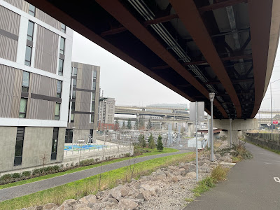
This part of the city has had a lot of recent light rail construction. There is the new (no car) bridge (which we call 'Bob') and a lot of interconnection overpasses carrying the light rail that goes with it. The bike paths wind underneath this (and the Interstate going through (over) town). A little noisy but it does have another sort of post apocalyptic grace. Follow the signs. Soon you will enter the river park.
Now we are back off of the road and on the trail that goes right down the river next to the main downtown part of Portland. This area used to be wharf space and still has the large cleat tie-ups from a time when merchant ships used to unload their wares in this part of town. Now a-days there are only boats tied up here during the Rose Festival when a few military vessels (the Canadians ones are very nice) come up the Columbia and tie up for tours and general impressiveness. (Why are the Canadian ones nice? Because they allow tours without having to go through intense security. )


Oh, there is one boat that is tied up permanently, and that is the steam powered stern wheel tug, The Portland. It is the last stern wheeler tug made and it is still operational. In fact, it was used in the movie "Maverick". Today it is a floating museum. Across the park from the Portland is the signal bridge of the 1800s battle ship Oregon. This old beauty used to be tied to the wharf (presumably along with the stern wheeler) as a museum and tourist attraction. It was recalled to action, however, during WWII and used as a cargo hulk during the invasion of Guam. Wars are always messing with my museum experiences.


Now the trail passes through the area used on weekends (during warmer weather) for "The Saturday Market". This is Porltand's market of local art and other fun stuff. This is a great thing to come to on a weekend to walk around and enjoy the art and have some lunch at at food cart. Come in November and get some nice Christmas Presents. During normal (non-covid) times, the market is open every day during the month of December up til Christmas and billed as the Market of the Last Minute.
I forgot to mention that we have been passing a number of bridges. This is because the trail goes under the bridges and didn't impact our progress. But right ahead the trail dead ends. You either need to jog left into the china town, or jog right and go across the Steel Bridge over to the East side of the river.
 |
| The Middle bottom section telescopes up into the upper section |
The Steel bridge is a 2 deck bridge. The bottom deck, which is very close to the river, carries the Union Pacific Railroad crossing and the river trail pedestrian traffic. The top span carries light rail (both the Street Car and the Max) and highway 99 car traffic. This makes the Steel bridge one of the most multi-modal bridges in the world. In addition, it is the only bridge in the world with dual independent lifts to accommodate river traffic. The bottom level can be lifted independently of the top level and will telescope in the top level without impacting top level traffic. For a really tall ship, the top level will rise up with the bottom level telescoped in.
 |
 |
| Floating Walkway near the scenic river |
On the other side of the bridge starts the Vera Katz Eastbank Esplanade. Vera Katz was a much loved Mayor of Portland and the trail that bears her name is a well maintained mix of floating and shore paths to travels from the steel bridge to OMSI. You get a good view of the downtown part of Portland from over here, though today the tops of the highest buildings are obscured by fog. There are a lot of offbeat art sculptors and such alone the river. In one area there is what looks like an ampitheater set up under one of the cross river bridges. As far as I can tell, it is a place to stand and listen to the thundering traffic going by overhead on the steal plates of the bridge. On another section of the trail, the fence that separates the trail from the river embankment is covered with hundreds, perhaps thousands, of padlocks. Closer inspection shows these locks are decorated with the names of lovers. The so called 'locks of love'. I believe the tradition is to show that you love someone forever by painting your names on the lock(s), locking them to the fence, and then throwing the key into the river. Unclear to me what the combination locks add to this mix.¹


Now we come to OMSI, the Oregon Museum of Science and Industry. Lots of cool things inside, though it does play heavily to kids and schools. Outside, parked in the river, is a attack Submarine. This is the one used in the movie "The Hunt for Red October". You can go for tours of the sub if you want.
 |
| Willamette River Map on Walk |


I am still peddling. Now, with only a slight detour, I get onto the old Rails To Trails route called The Spring Water corridor. This leads under the Ross Island Bridge and along the souring river embankment through what should be a beautiful urban wooded area. The beauty is jarringly impacted, however, by the steady growth of homeless encampments that have been springing up since just before OMSI. The encampments in the city tend to be small and clean. Out here they become more sprawling, hiding down in the woods, and the areas around them are huge piles of trash and waste. I don't know what the solution to the American homeless problem is, but I think it is time that we started putting more resources into finding something. Letting it be and hoping it goes away is not helping the people who need shelter and it is not a sustainable burden on the landscape. I am thinking that the cleanup costs are going to surpass the cost of taking some more humanitarian action.
A few of the shelters that have been built are really quite elaborate. Note the one built on the steep hill under the Ross Island Bridge that has wood walls, a roof, and what appears to be propane heating/cooking. I wonder what they do for water/sanitation?


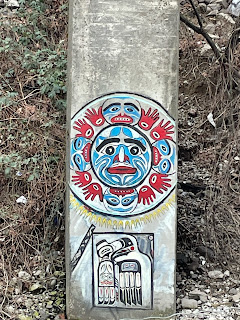 |
| Some Local Art |
Well, that is it. I can get going pretty fast on this no-car section of the trail and transit through Oak Bottom in just a few minutes back to Sellwood park and my car. Around 11 miles and an educational ride.


Have to try this ride again sometime when the sun is shining.
¹My partner objects to the throwing of the keys into the river as being not environmentally conscious enough for Portland. I can actually find no documentation one way or the other (on the internet) on the subject. However, I encourage all young lovers to try the "Oh, I am going to keep the key and recycle it later. Trust me, I think our love will last forever and none of the other locks on this bridge belong to me and someone else". My research did show that these "Love Key" bridges are all over the world, the most famous being in Paris. In many of these places the weight of the locks created a danger (or perhaps were unsightly) and caused the removal of the wall. In Paris they made it illegal. I am sure that worked. Personally, I would put up a special (easy to replace) fence section, put up some signage encouraging display of padlock affection and provide a non-openable lock box for the depositing of keys. Also, this is my first use of footnotes in a blog. What do you think?
Now I want to bike around Portland, too! I love under bridges and along rivers
ReplyDeletePortland has many bridges. The elementary kids all have to do reports on them.
ReplyDelete