Wednesday, September 9, 2015

Trails Around Multnomah Fall: A quick Guide

For the past few years I have been doing a lot of day hikes around the Multnomah falls area. It is pretty close to Portland, It has some nice elevation (exercise), usually has parking, and can be hiked in most weather for most of the year. There are also a number of different loops and semi-loops that can be added together to form many different hikes of different challenges. I thought I had written about most of these but I must have gotten mixed up with some Facebook postings.

Interesting, you can say "Facebook" on this blog site.

Anyway, I decided to put together a general map and trail description of the area with pointers out to any more detailed blogs I may have done.

I have provided links to any in-depth blogs I may have generated over the years.
I don't like the map they hand out or post on the trails. I think it is misleading. So refer to the one below instead. You may want to print yourself a copy. I don't think Google will mind.


I have tried to place markers for the trail start and stop options. Some of the actual trails I have marked. The back way to Devil's Rest (Neskia Lodge Road) is a somewhat notional marking as it doesn't appear to be on maps anymore. Working with Google maps on that one.


Starting Points: (Well, technically end points also)

1)  Angel's Rest Trailhead
Unless you are really in for a big hike, you only start here if you are just doing Angel's Rest. I like Angel's Rest a lot, but the trail up can be pretty slippery and muddy.
There's a medium amount of parking. A lot of parking if you are OK leaving your car on the side of the road. This can be a very popular hike in the summer.


2) Wahkeena Falls
A small parking lot at the trail head. Really only meant for cars for tourists stopping to see the falls. Still, if you get there early, or just get lucky, you might find a spot. If you can't park here, you can park at Multnomah in the main lot or the highway 30 lot and take the half mile feeder trail above the road to start your hike here. This is a good starting spot for any of the loops or extended loops.


3) Multnomah Falls.
If you like people watching, this is a good starting spot. Lots and lots of parking, but there can be lots and lots and lots of people. Getting here around noon on the Fourth of July, for instance, is craziness. Using this as a starting point is pretty much identical to starting at Wahkeena. The connector trail is less than a half mile and you can do the many loops in either direction. And here there be soft serve ice-cream.


Loops and Loop Segments (Meta loops?)

1) Multnomah Wahkeena
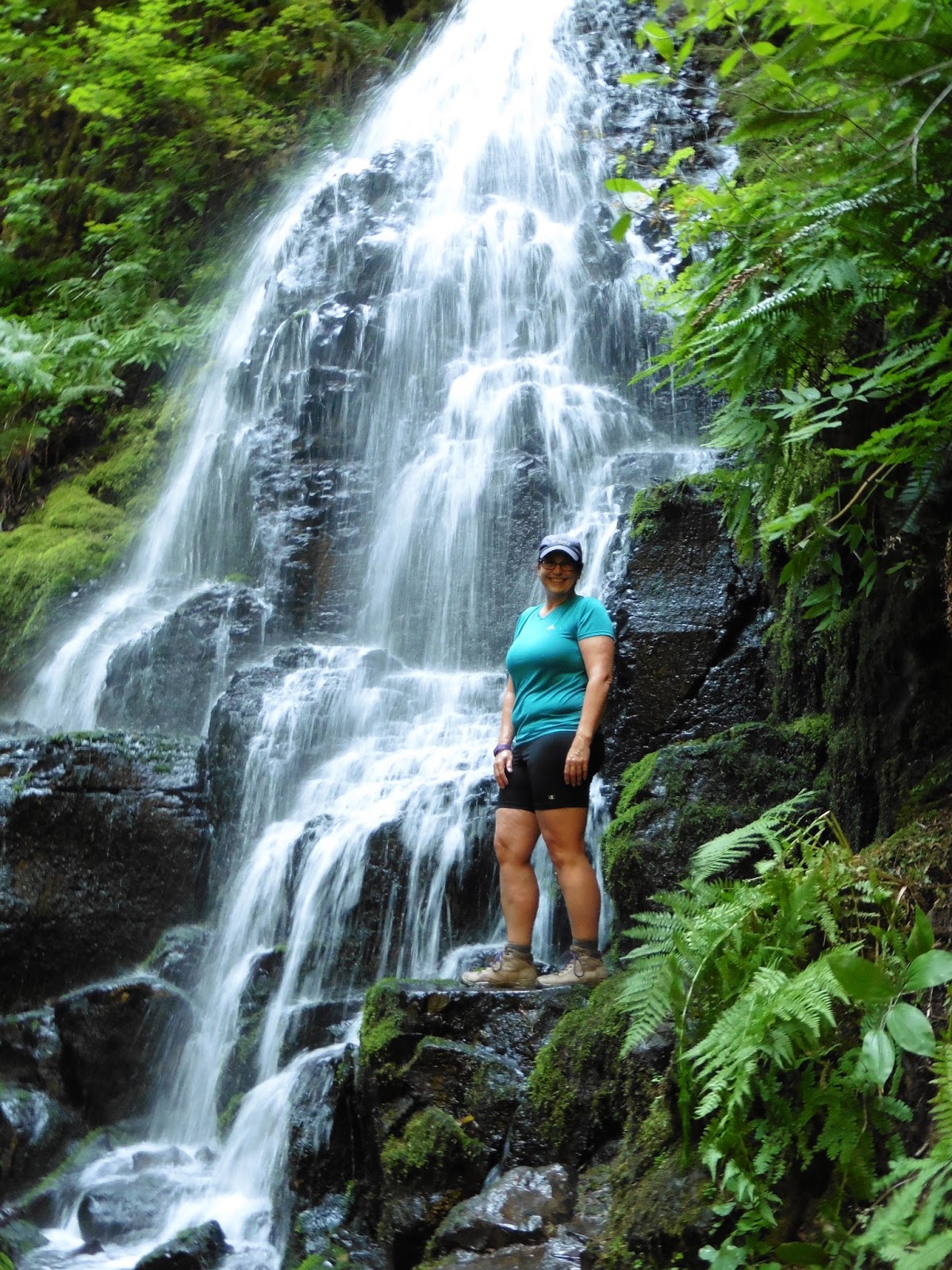
Start at either of these falls. Go either direction. Change it up a bit. Hike past these 3 intersections: Wahkeena Springs, The CrossRoads. Larch Mountain Trail. This is a nice 5 mile hike. Lots of waterfalls. Plenty of water all year round.  The Crossroads is the halfway point and is the perfect spot for some lunch and casual conversations with people that don't have as good a map as you do.


2) Crossroads to Devil's Rest Plateau.
I marked "The Crossroads" on "The Map".  It isn't really called the Crossroads. But I call it that. I have tried repeatly to make it a "place" on Facebook. So when you are there, try to check in. I think I called it "Multnomah Wakeenah Crossroads". Or perhaps "Multnomah Wahkeena Crossroads". Just 50 feet down the trail is the (marked) trail up to Devil's Rest. I often go up that way to the plateau right near where I marked the Nesika Lodge road. That is a great place to hang out. I once ate Easter Dinner up there.   1.5 mils?


3) Wahkeena Springs to Devil's Rest (and Devil's Rest Plateau). 
Wahkeena springs is actually a marked turn off the trail right near the top of the climb up from Wahkeena falls. If you Head south following the trail toward Angel's rest, you will be doing this hike. Keep an eye out for handmade sign marking "Foxglove Trail". The Fox glove goes up and eventually leads to another crossroads marked with a sign to Devil's rest. I have marked this on the map as "Foxglove to Devil's Rest". I am a little unsure about what the map is showing for the first lefthand turn off of Foxglove. I don't remember there being an actual decision point here and it may be that some of that trail has become overgrown. Anyway, you can loop up past Devil's rest and eventually get to the Devil's rest Plateau described in loop (2). 3 miles?


4) Larch Mountain Trail to Devil's Rest (The Back Way).
The Trail up from Multnomah falls is also Larch Mountain Trail #441. If you are doing loop (1) you would take Wahkeena Springs trail #420 toward the Crossroads. BUT.... if you keep going up Larch mountain trail, you will soon find a bridge across Wahkeena Creek and then a pleasant continued hike along the river. At one point there is a high and low water turn out. Eventually you will come to a place where the trail crosses a dirt road. Turn right onto this road and you will soon cross a (car accessible) bridge. You are on what I am calling the Nesika Lodge Road. The last time I hiked this road the bridge was closed to cars, but I understand that it has been fixed. This is a an access road to some property owned by the Trail Club of Portland. Follow it up and around (you may have to negotiate a locked traffic gate) until you see some partially hidden signs and a space that might be for parking. There is a trail there off the road and if you go back 100 feet you will hit the Devil's Rest Plateau. Come down using loops (2) or (3). 3 miles?


5) Wahkeena to Angel's Rest.
Just follow the Angel's Rest Trail form the springs. You will get to go through some nice forest and potential camp grounds before you meet up with the Foxglove train again right at Angels Rest.  Lots of poison oak at Angel's Rest. Just saying.

Friday, September 4, 2015

Lunch time at Devil’s Rest.

Lunch time at Devil’s Rest


I do a lot of hiking around Multnomah and Wakeenah Falls. The area is at the West entrance to the incredible Columbia Gorge Scenic area and only about 30 minutes east of Portland. There is a lot of parking in the area, which is good because Multnomah Falls is the biggest tourist attraction in the state and there are ALWAYS hundreds of people there. But don’t let that scare you off because that is actually part of the appeal. All of these people are all over the place down at the base of the falls, but if you persevere and climb up on the very well groomed (and for the first mile, paved) trails, you can get past the reach of the first milers and into some truly wonderful wilderness. You will still run into a few hikers and/or lost tourists. But for the most part, these are all kindred spirits who have made it up to the ridge. Offer them some tea or a cookie and give them directions back to their car. It is all good.

When the Columbia Gorge got cut, during the last  days of the last ice age, it scourged though some old lava flows to make the Gorge as we see it today. To do most of the hikes in the area, you have to climb up to the top of the cliffs. This is about a 1000 foot climb usually done in the first mile of the trail. In the area of Multnomah, you can ascend either at Multnomah falls, Wakeenah falls, or Angel's Rest.  I usually like to do one of the Falls. Angel's Rest is OK, but the trail is a lot more muddy than the other two and just not as picturesque (though the view from Angel’s Rest is wonderful).

On the hike my Partner and I are doing today, we are going to take a very little traveled route up to the local elevation maximum of the area, Devil’s Rest.  We got lucky and got a parking spot on the old route 30 right in the lot at the base of Wakeenah falls. This area is often full after 9:00am and during the summer the traffic trying to get to Multnomah (the next falls and parking lot East)  often backs up the half mile to Wakeenah. 

Like Multnomah, the climb out of the gorge is paved. It is a steep paved set of switchbacks straight up the side of the cliffs. There is good shade from the trees growing there, however, and there are benches along the way to rest. I like to take a short break at each switch back. It gives me a chance to look back down the trail and out over the Columbia river. The Columbia runs east to west, so for much of the year, the sun is low in the South and the climb is all in shadow with the Washington side (over North across the river) revealed in bright sunlight. Today, however, is the middle of summer and everything is sunny and hot. In fact, the temperature today in Portland is supposed to hit 100 by 2:00, so my partner insisted that we get out on the trail early and get this climb done. Right.

Once this trail gets to the top of the paved part (at a nice overlook named after a fallen forest fire fighter) it meets the Wakeenah river and then does a constant set of short switchbacks up the Wakeenah canyon. This trail can be a little muddy and slippery in the winter but is pretty dry and easy this time of year. There are a lot of big trees growing up the canyon wall, and down by the water are many stands of Devil's Club.

Fairy Falls and a Wood Sprite

About halfway to the ridge, you find Fairy Falls. This is a pleasant little cascade that is the final destination of most of the intrepid tourists. We still have a ways to go though, so we push on.
At the top of the switchbacks you run into fir forest and a more flat terrain. This is the lower ridge. We are going to hike along it and then eventually ascend up to the upper ridge where we will find Devil’s Rest. The usual way to do that is to follow the signs east toward Multnomah river and take the offshoot trail up to the upper ridge. We are going to go the longer way around by first hiking over toward Angel’s Rest and then picking up the foxglove trail. So we take the right hand trail. 100 feet down this way we hit Wakeenah Springs. This is where the entire Wakeenah stream comes bubbling right out of the rocks at this nice little shaded area.

Wakeenah Spring. 


This is a great spot for have lunch and relax. Today, we are going to stop here for just long enough to top off our water bladders. I have brought my little filter and we quickly fill up. The water here is very cold, even at this time of the summer, and the flow is also strong and clear. I probably don’t need to filter, but I don’t see a reason to risk it. Something I realized about Wakeenah, though we are in the midst of a dry hot spell and at the end of the summer, when all of the other creeks and streams are really low (Multnomah falls, for instance, is a shade of its normal glory) Wakeenah is flowing along just fine. In fact, it seems to be pretty much the same as it looks during the winter rains. The source of the underground spring must mitigate the high and low water levels. I wonder how that works. Is there some great huge underwater lake up in the higher hills with a little out flow near the bottom that feeds underground to the springs? So the flow will be just about constant no matter what unless the secret reservoir runs out of water?  I am going to say it is unless Wikipedia wants to contradict me. (An internet search finds nothing except other people saying how nice it is to hike this loop. I will interpret their posts as reverse time derivatives of my work).


The springs area is a nice shade place. One of the areas flat enough to put up a tent (though you are not supposed to camp within 100 feet of water) and home to a nice stand of cypress (which are called something else on this coast but I forget what). There is also a curious little side stream that is all pebbled with red stones. You don’t see that color stones anywhere else in the area. 

The trail is now heading West down the Gorge with the occasional switchback to gain altitude. We are slowly working our way up the ridge and over toward Angel’s Rest. There's good tree cover from the hot sun here. On one of the switchbacks, we cross a scree of old basalt. The falling rock has knocked down the local trees (a few hundred years ago) and opens up a very nice view of the Columbia River facing East.  At the top of the scree we level out again and now it is just a few little bends around the tops of little valleys and small streams before we get to the left turn that is the side trail up to Devil’s Rest.

The Scree with a View
This side trail is called “The Foxglove Trail”.  This is not an “official” trail. It is marked and semi-maintained by unknown persons. It goes up the hill, connects with an old lumber trail, intersects the trail to Devil’s Rest and then loops back down to the Angel’s Rest trail (the one we are currently standing on). Today, this trail would be better named “The Salmonberry Trail” or perhaps “The Bramble Trail”. It is fairly overgrown for the first half mile we are on it and my partner and I got torn up a bit as we went. So bring a stick or a hiking pole or something to fight off the brambles.  Editor's Note: And the cobwebs, lots of spiders scrambling around trying to get out of my hair.

Remember all of those people we saw down by the trailhead on the Historic Highway? They haven’t made it up here. We have only seen one person since we left the springs. Now we are turning to make our way up on the Devil’s Rest trail. Be on the look out for the signs on the trees here as it can be easy to miss your way and get turned around.

I came this way once in the winter in the snow and damned near got myself lost and benighted before I turned around. It was a strange thing. I had seen the signs that said things like “Devil’s Rest” and “Angel’s Rest” but I was convinced that they were all pointing the wrong way. This turns out to be a sure sign your are lost. I was trying to get to Devil’s rest, and I thought I was going the right way. I was following the foot prints in the snow of a couple of hikers and they surely must have known where they were going. I would either find Devil’s Rest, or I would run into them. So I followed and followed. The way kept getting harder and harder and looking less and less like a real path. Surely I would hit something I recognized soon? It started to snow again and it was getting on toward the afternoon. Sun goes down around 4:30 this time of year so I really needed to be getting someplace soon. That is when the footsteps stop. Both pairs just stopped. What? Did they fly off? Then it hit me. It wasn’t a couple of hikers. It was one hiker. He had just turned around and I didn’t realize one set of footprints was going in the other direction. CRAP. I turned back and decided just to retrace back to my car. Then I saw my shadow. It was long a tracing out in front of me. In Front of me? Crap, I had been hiking 180 degrees in the wrong direction. It was cold. I was low on water. I had very little emergency overnight stuff. Just a light bivy. Got to be more careful in the future when I am out alone in the snow. 

But today I am out with my Partner in the Hot sun. And I have a lot of water. And we are starting up the now fully trusted and signed trail to Devil’s Rest. The only problem with it is that this trail is very steep. So steep that we both get winded on the way up and need to stop several times. We pass another couple on their way down. They give us the usual hiker greeting “Don’t worry, not much further. It is worth it !!”. The man tells us that Devil’s Rest is pretty cool and we should look for the pitchfork shaped tree that gives the place its name. The woman tells us to be on the lookout for the hidden grotto down underneath the boulders. There is a little shrine there. Okay. That sounds like fun.

The Grotto at Devil's Rest

Devil's Rest Boulders

Still some climbing to do before we get to the place, perhaps another 30 minutes. We are up on the top of the plateau by now and things are leveling out. You can see Devil’s Rest pretty clearly on a topographical map. It is the highest little circle in the area. But looking at it when you are there is a little less exciting. It is a nice jumble of big moss covered boulders. But the only view you have is of the towering trees that are all around you. We didn’t see the pitchfork tree (and I really don’t believe that is the source of the name) but we did find the little grotto. I get the feeling that this used to be a little place for gnomes to visit, but now it was sort of a place that people left little trinkets. Almost trash. Perhaps it is a geocacheing site.

So. A lot of hard climbing to get to a poor view. But take heart, if you continue on the same trail past Devil’s rest, you soon come to the Columbia Gorge cliff face. There is a side trail to a very nice overlook. A place where we could even see Mt. Rainer just peeking over the top of the hills across on the Washington side (or was that Adam’s? must check the pictures).


I guess that must be Mount Adams.

The trail winds it’s way down to a very nice plateau that is pretty much straight up from Wakeena springs. There is a lot of local water up here. Just little seeps and a couple of very small streams. But the entire area is a little wet. Perhaps this is the top of that underwater lake that supplies the springs. This is another great place to camp. There are a lot of flat areas that you could put up tents or hammocks and just enough water to filter even this time of year. And I have never seen anyone camping up here.  The funny thing is that just a 100 feet south from this area. Hidden right over there in the woods. Is a road. Strangest thing to think you are out in the boonies and then come across this road. This is a dirt road that goes down and across Multnomah creek to get to the lodge owned by the Portland Club. I hike up that way to Devil’s Rest on occasion.


Okay. So I got you up to the plateau up by Devil’s Rest. But what I really wanted to do was show you a map of the area that has the trails marked and is better than those terrible maps they hand out at the ranger's station. I am going to see if I can create one with Google's new map editor (even though I hate that thing).  OK. I changed my mind. I decided to do a different post that is just about the map. I will link it here when it is done.

see ya.