
There are some names of places and things that get repeated all over the country. For instance, we are visiting Lincoln City. There are cities named Lincoln in pretty much every state (and several called Lincoln City). We happen to be visiting the charming one on the Oregon coast. Then there are common names for creeks and rivers. Falls Creek. Fall River. Elk Creek. Swift Creek (lots of these) and Drift Creek (lots of these also). Today we are taking a little detour just short of Lincoln City to go off on Forest Service road 14 to find our way to the trailhead for Drift Creek Falls hike.
I had always thought of this as a hidden little hard-to-get-to hike. I thought this because the map has it way out in the forest down this forest service road that last year was listed as ‘closed about a mile from the trailhead if coming in from the coast due to a landslide’.
Forest Service roads are usually the roads that have been cut to get into the forest to provide service. The main service is the forced removal of said forest to make houses and firewood. These roads are usually gravel or just dirt and often are best served using a 4 wheel drive vehicle. The guide book says the roads are good all the way to the trailhead and you can access said trailhead from the North (off of highway 18 on your way to Lincoln City from Salem) or from just south of Lincoln City). We came in the North on what started out as a wide but well maintained gravel road but then turned into a 1.5 lane paved road winding through the thickly wooded forest. We had got ourselves into a little caravan of cars (which was unusual) and immediately ran into a Tractor Trailer rig pulling a full load of felled big trees. All cars had to back up and find one of the frequent wide places to get out of the way. It turned out this was sort of unusual, because we didn’t see any more trucks on that road nor any more cars going in that direction (the operative phrase being ‘that direction’).
Word of Warning here: If you are coming in from the North, don’t trust Siri. That little trickster tried very hard to take us the long way around, essentially routing us out to the beach and then up the long way from the south. Sneaky. We were lucky enough that the car behind us knew the right way to go. There was also a big sign that pointed straight ahead right at the V in the road, but one could argue that straight ahead was in either direction.
Anyway, we wind down the road being careful to avoid oncoming timber trucks until we came to the trailhead. I am thinking, well, here we are 10 miles out a little one lane forest service road, we are going to be the only people at this little secret hiking spot.
WRONG
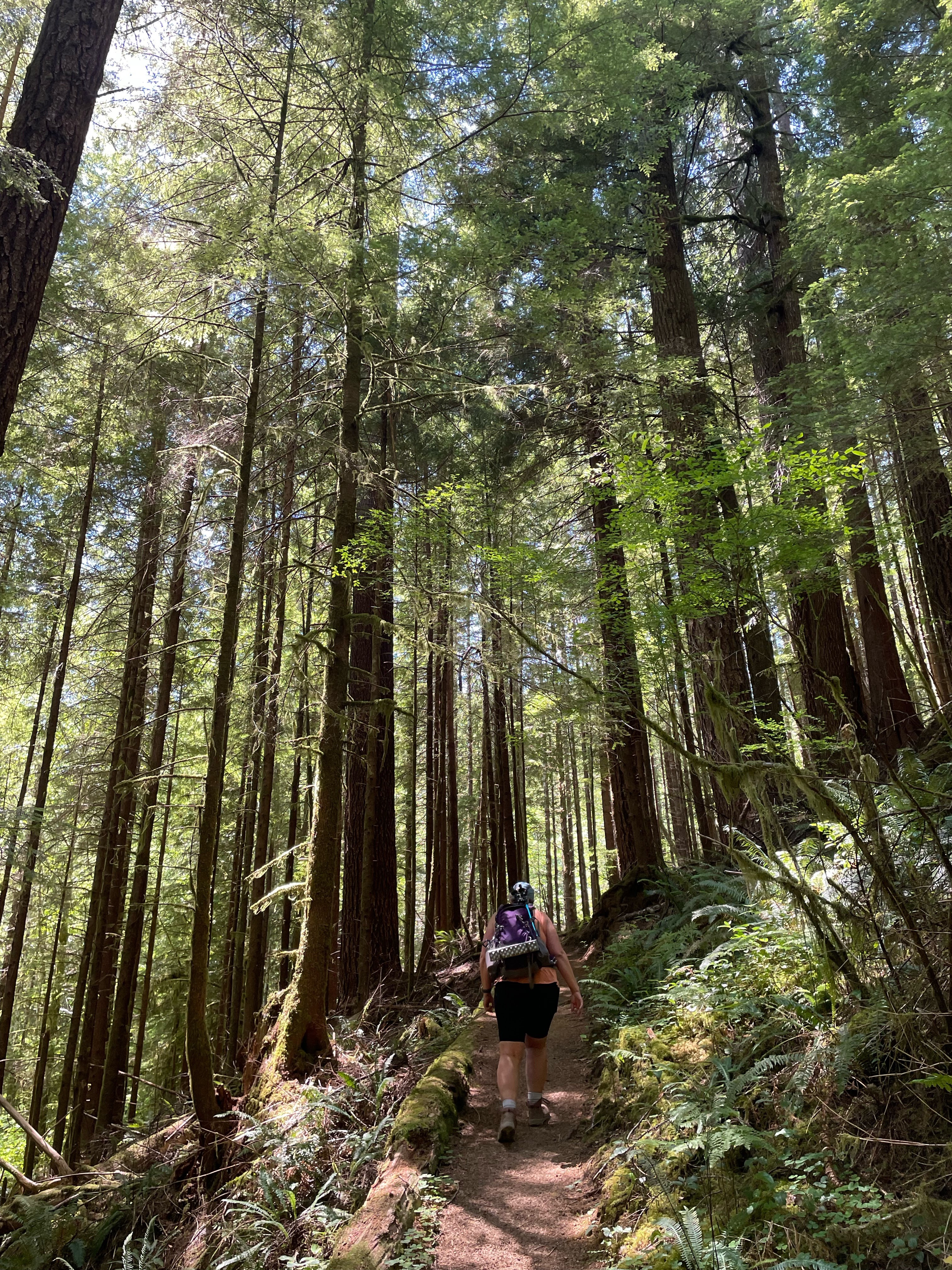
The largish parking lot was full and more cars were streaming in even as we parked on the side of the road. All sorts of people there. Lots of teenagers and children. LOTS of teenagers and children. The trail started out up on the ridge and then you hike down to the creek and around to the waterfall. So we are going downhill first (this is my second favorite direction only losing out to the exact opposite of this). The initial part of the trail is through a forest of relatively young Doug Fir. It is a well maintain forest, however, and the trees have good separation and are healthy. Even with my new knee I guess I cannot maintain a very fast pace because we were passed by Everyone. Big groups of people. We would pull to the side when things got too noisy behind us and groups of 10 or 15 would go past. Families with everyone along. Even grandma was passing us laughing with her grandchildren. We must have seen at least 50 people on the trail, which pretty much matches up with the number of cars in the parking lot. With this many people, things are not quiet. Lots of laughing and talking and a fair amount of whining.
The trail continues down through this young forest (I am guessing the big trees were less than 100 years old. Perhaps as little as 50.) as it winds its way down to the river. I can hear the river off to the right. Other than the age of the trees, this is a typical healthy wet Pacific Northwest coastal forest. Lots of Salaal. Some Oregon grape. Plenty of sword fern. Some less usual plants that we saw included Salmon berry and a new fern that I will get to later.


At the bottom of the slope, after about a mile, you come to a footbridge over a little gurgling stream. As you cross the stream you enter a grove of old growth cedar. Big trees that seem to have avoided the lumber man's saw. Perhaps this side of the valley was too difficult to access. Certainly the lumber roads are not running through here. This entire area is part of the Siuslaw National Forest, perhaps lumbering is no longer allowed on those lands. No, I checked, BLM and Siuslaw National Forest work together to manage the land (that means, cut down the trees).
Now the trail follows the creek through this stand of lovely big trees. I have never done this hike so it is unclear to me what to expect next, but I know there is a waterfall someplace along here…
Then, up ahead through the trees, I glimpse the towers of the suspension bridge that I saw on the map. I expect it to be going over the creek that we are following (on our right) but I now realize that this bridge is much larger than I had been expecting and is going off out of my view to the left.

We come around some trees and pull up next to the little stream and I can see that we are standing on some prominence, perhaps a cliff, and the bridge is reaching out over the void to a cliff wall 100 feet across a river gorge. Oh boy. The bridge is just barely wide enough for 2 hikers and is a classic 2 wire suspension bridge. We start across. When you get to the middle you can look back and see the wonderful little falls that is the cause of all of this engineering. That little creek that we were following has spent that last centuries digging a little gorge through a lava flow up high. But that lava flow ends and so the creek must come bursting out of its gorge and making a lovely little fall into a different creek/river 100 feet below it. It lands on a jumble of large boulders that have calved off from the lava flow up top and now provide a place for intrepid youth to clamber for a better view of the falls.


We stop on the other side of the bridge to admire the view, but the trail goes on and my partner gets me moving again to continue to the end. It goes off down the main river and then switch backs down to a nice view at the base of the falls. Be careful here, there are a couple of places that the trail is made of closely packed round river rocks and dirt, and when wet, are incredibly slippery. Like so slippery you can’t walk on it without extreme care. 12 year olds appear to have no problem. I wonder if their shoes are especially sticky.


This is a great place for a snack and some re-hydration and to talk to some of the people on the trail. We are probably the best prepared hikers on this trail. It is only around 1.5 miles from the trailhead to the falls and many people are in sneakers with no packs or water. I always hike with my trekking poles and water and once you have to carry that, you might as well bring the full 10 essentials that are printed right on many of the REI packs. I actually do carry many of the 10 essentials. I have a knife and a compass and some waterproof matches. I also have a tarp and some rope so I could build an emergency shelter. I usually have a bivy sack (just a sack made out of that space blanket material). My general goal is that I could survive if I fell and broke my leg and my partner had to go for help. Perhaps over night. My real goal, if I am being honest, is to appear prepared enough to impress whomever I am hiking with. For instance, some of the things I have brought out to hand to people: A snack. Some toilet paper. A square neckerchief to tie around a cut hand. A rain and wind shelter. A extra pair of socks. I used to carry a little stove to make tea, but I don’t usually do that in the summer. I have this idea of setting up a little tea stop up on a heavily used pass in the Columbia Gorge some cold fall day just serve tea to people as they pass by. I haven’t quite got up to that yet, though I think it would make a great story.
On the way back to the car, we do a signed side loop called ‘The North Loop’. It starts just after crossing back over the other smaller footbridge and winds away anti-clockwise up the slope adding about another mile to the trail. It is a much less traveled trail and my partner, who was leading, had to do some Salmonberry clearing to get through. Salmonberry is particularly grabby, with lots of little thorns that you think you can ignore until you see the blood on your arms and legs. Once through that we were back into some big trees. Bigger than the start of the hike. This is also where we ran into this new, to us, fern. I had though it must be deer fern, but it wasn’t growing on a maple tree. It has a leaf pattern similar to deer fern and it has long black stems. They were growing everywhere along this part of the trail. The internets tell me that it is, well, it is Deer Fern. Further it tells me that Deer Fern has two kinds of stems. The usual green stem around the base of the plant is sterile. Then the upright black stemmed fronds in the center are fertile and short lived. This makes me think that I don’t really know what that kind of fern that I see growing on the giant leaf maple trees over in Portland are. There is always more research to do.


It was nice to get away from the crowds on the North Loop, but we soon met up with the main trail, up on top of the ridge, and then had another half mile of being passed by pretty much the same people we had seen on the bottom before we got to our car. We had sat down once to take a little break and see the people go by, but we got a little swarmed by biting flies, so we got going again. Not sure I have ever been swarmed by biting flies in the PNW before. Must be attracted by all of the very edible humans.
Back at the trail head and the parking lot is now only half full. Truth be told, we have made this excursion to the coast to escape from the heatwave that has been predicted in Portland. 100 degree weather in the Willamette Valley but it is going to be 60 or 70 on the coast. You never know if you have enough warm clothing when you venture to the Oregon coast. We are staying in one of our favorite motels, The Inn at Spanish Head. All of the rooms have balconies overlooking the beach and I am sitting out there early in the morning, listening to the waves, which I know are out there someplace but I can’t quite see because of the fog, while I type this blog. I Wonder if the fog lift by noon?

No comments:
Post a Comment