
My partner has been wanting to take me to Falls Creek Falls since last year when she went on one of her Best Friend Monday hikes. I couldn’t go then because I was just one month into recovery from total knee joint replacement (also, I don't always get invited on Best Friend hikes), but this year I am strong and mobil and eager to see the sights.
Falls Creek is up a tribitary river of the Columbia just east of Cascade Locks and on the Washington side. This is a region of lots of lumbering activity and tourist trade. The state and federal authorities have vast reaches of forest that are either protected or managed for timber production. If you look at a satellite <link> view of this part of Washington, it looks like a patch work of different shades of green and brown indicating different age ‘harvests’ (clear cut). Falls Creek comes down off of a plateau of basalt (as so many rivers in the PNW do) making a pretty splendid valley and small gorge. Hard to lumber, expensive to build forest roads into, perfect to preserve for outdoor enthusiasts.
The drive takes about 90 minutes, with the last 10 or so on dirt and gravel roads, some of them very rutted. An all wheel drive is probably nice but there were all sorts of family cars parked at the trailhead. My partner says that she was surprised there were not more people at the trailhead and that the parking is often full. That surprised me since this is a bit out of the way and the parking lot was pretty large (say….. 30 vehicles?). Plenty of parking down the dirt road if need be.
This area is in the Gifford Pinchot national forest. Some places around here require a North West Forest pass or equivelant but we didn’t see a sign for such at the trailhead. There is also a pit toilet at the trailhead, which is nice. There is no water except that from the creek, which is not often accessible due to the little (10-20 foot) gorge it is usually in.
This hike has a connector trail to a higher longer trail that you can use to do a circular route which we have elected to do in a anti-clockwise direction. This means that the first part of the hike is mostly level and follows the south side of Falls Creek up stream.
 |
| Lots of Mahonia (Oregon Grape) |

Falls Creek is a lovely creek. It has steep (sometimes sheer) banks and is loaded with large round boulder and huge deadfall trees that have all become liberally covered in deep green moss. The water is fast moving and cascades down many embankments. Other places huge trees have fallen across the creek to form natural dams, with the water pooling up behind and then splashing over. Stop often. Soak in the sights. This is the sort of thing that one (well, I) can’t capture adequately with photography.
The forest undergrowth is very green after all of the rain we had this spring. So much Mahonia (Oregon Grape). This is the short bushy variety. My partner was also busy taking pictures of new flowers for the season. Lots of unidentified little white flowers (LWFs). I will pull out my field guide and see what can be found. One of our hiking friends has an AP on her phone that does a good job identifying plants. I haven’t decided yet if that is kosher.


 |
| Nurse Tree!! |

After a half mile or so there is a little (but sturdy) suspension bridge that takes you across to the North side of the creek. There is a lot of equestrian and bicycle activity in this area, but this bridge is listed as human foot traffic only. Horses and Bikes are not supposed to use this part of the trail. They can use the upper trail that we will be coming back on. That trail goes miles and miles along the ridge above the creek to Falls Creek Horse Camp.


The trail is now a little more challenging in spots, as we are up against the North slope of the valley that the creek as formed. Some places the trail is steep to on the right and everything was a little wet from some occasional rain which has made things a little slippery. My partner has deployed her trekking poles and I have one of mine out as a staff, (though I was thinking that I really needed to be using both also).
Huge Douglass Fir Trees along through here, along with occasional Maple and Cedar.
We come to a little dry wash where there is a fork in the trail. Left goes pretty much straight up the hill to connect to the upper trail. We will use that on our way back. But first we will follow the trail to the right that is a .5 mile out and back to the foot of Falls Creek Falls.
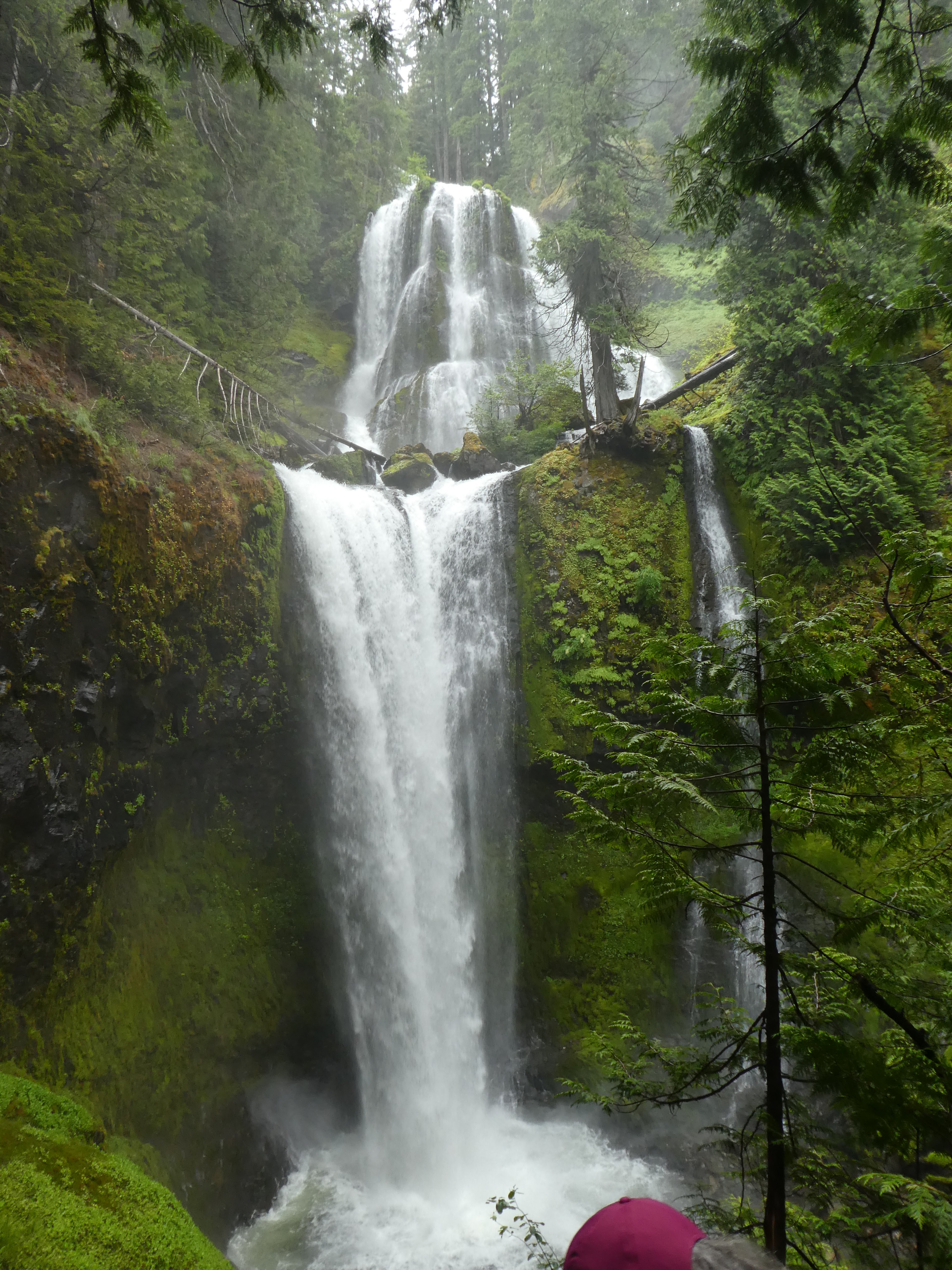
Falls Creek Falls. Was the creek named after the falls, or the falls named after the creek? Or did some guy name Phineas Falls once build a cabin down at the mouth of the creek and it was named after him?
Whatever the case, the falls are stunning. They are a double set of sharp falls with a wonderful pleateau of cascading falls between them. The viewpoint is 50 foot above the round pool at the foot of the falls. It is just in the spray pattern from the rolling water and would be a lovely cool place to hang on a hot summer day. Today is moderate, so it is a bit chilly standing there on the boulder strewn cliff. This may be my vote for most beautiful falls in the PNW. It is not as tall, but has perhaps more water than Multnomah and is much more complex than any of the falls at Silver Falls. The little plateau in the middle is especially striking with many boulders and little live trees breaking up the rapid flow of the white water. I sure hope some of these pictures give you a feel of the place.


Enough Water Fall? Good, then time for the hard part. We head back to that uphill connector.
Up until this time we have had the trail pretty much to ourselves, but the late morning crowd must have started to arrive because we are now passing a few groups of people. A family with some kids, but mostly older (probably retired) people. My partner and I have our trekking poles out and are using them carefully on this part of the trail. We are taking care of our old knees. Here comes a woman walking toward us, she is about our age but very thin. She is walking without trekking poles, in fact, she is carrying a medium size glass casserole dish in one hand and a spoon in the other. She is eating out of the dish as she walks calmly across the rock strewn trail. She casually says hi to us between spoonfulls of her on the go snack. I hate people like that.
We get to the up part and shift into low gear. This little connector to the high trail is as steep as my partner promissed, but it is very short. The map says it is .2 miles. For me, a mile is around 3200 steps. So .2 is 640 steps. Easy Peasy. Only had to rest once on the way up. We get to the upper trail and now we can either turn left and take the long way back to the “parking lot”, or we can add another little out and back to see the top of the falls.
This is about a mile each way and we have to climb up to the top of the basalt pleateau that the river is coming tumbling down. So more up hill for about half a mile and then the ecosystem changes. We are now on a wide flat area. We still have the Doug Firs, but we also have some other scraggier pines and everything has moss in it. The understory has less mahonia and has more smaller plants. In particular, it has one of my favorites, Bunch Berry. This is a little 3 leaf plant that has a flower that looks like a dogwood tree flower. The guide book says it is in the dogwood family but I am not sure I understand what that means. Does it mean they have similar genetics or does it mean that they happen to look similar. It is called bunch berry because later in the summer it will have a little bunch of 2 or 3 red berries. That is pretty also. I tried to grow them in my back yard along with the other Oregon native plants that I have, but didn’t have much luck. I think my few Doug Firs just don’t provide enough cool shade for the bunch berry.


 |
| That white is the falls |

 |
| Bunchberry !! |
After walking through this pretty green flatness for while we come to an unmarked trail junction. We bare right for a few hundred feet and we are suddenly on the top of the shear cliff that borders the valley that Falls Creek must have cut. We are quite a ways from the top of the falls, maybe half a mile, but this is clearly as close are we are going to get. The view shows that there are some number of cascade falls above the part that we could see from the bottom. I am envisioning a long cascade of falls as the river comes down off of the basalt flow, and the big curtain falls a the end as it goes over a cliff.
This is a good place for lunch and a little rest before we start back down.
The return journey is pretty easy. Almost exclusively downhill or level with lots of BIG trees to see. Also lots of very large trees that have fallen recently. We saw some more hikers and we were passed by a couple of cyclists.

I have to remember to be careful at the end of hikes. That is when I get tired and don’t pay proper attention to where I am putting my feet. On this day I slipped on a wet rock and ended up on my butt with a bent trekking pole. Dammit. Also I suspect I have a bruise someplace I can’t see. Well, if that is the worst thing that happens when I fall, I am a happy hiker.
No comments:
Post a Comment