Sunday, September 4, 2022

On Global Warming - Paddle Oregon 2022

On Global Warming:

This is the third time we have done Paddle Oregon since 2017 and never has the heat been so brutal. And it turns out we were lucky and the temperature didn’t get nearly as hot as was originally projected (101). Down on the river wasn’t so bad. You can wear a hat and long sleeves and keep both of those wet and then when you get too hot, you can swim in the cool (or cold) river water for 5 or 10 minutes and that brings your core right down to ‘happy’. 

But when you reach your camping spot and climb up out of the river bottom to where your gear is, the sun starts bouncing off of the rocks and dirt and if you can’t find some shade, things can get quite ‘grouchy’.  In the Albany area we were at a local farm that the farmer had graciously offered for our use. The 100 of us were spread out in some trees and a field that had been made available. The field had no shade and around 5 the sun came out from the cloud cover and it was very hot. Everyone was seeking shade. The dining area was in full sun and it was very hot to sit there. Myself and some others grabbed a couple of tables and moved them into the shade of the caterers truck (That was prime real estate, let me tell you).

Hard to have a group experience and build comradery when everyone is hiding from the sun. This didn’t used to happen on these trips. Oregon is having more and more 90-100 degree week long stretches. I believe we had 4 this summer with one more coming next week. The event planners are struggling to deal with the situation but their choices are rather limited.

Shade tents?  Renting a big tent is expensive. Not only that, but you have to move it every day as the group goes down the river. That would add too much to the cost of the event and really doesn’t add all that much to the perceived value of the experience. Perhaps a few smaller shade tents with misting devices? Sort of distributed cooling stations? That could work. Hell, you could probably have one of those per pod and beg some tarps from participants, I have a shade tent that could hold 6-10 people sitting in chairs. Then just add some of those hand held plastic bottle misters and some cold beverages. Yeah, that’s the ticket. Though that doesn’t get you through a dinner.

How about this – do a time shift. Have the evening experience later. Right now they expect you to get into camp between 3-4.  Live music (really good live music) and refreshments start at 4 with dinner at 6. Sundown is around 8. The sun goes behind the trees (in some places) around 7. I say push everything back an hour. Tell people to start later in the morning or just hang out swimming in the river for another hour or so. Perhaps even move some enticements down to the river (perhaps have cold non-alcoholic beverages at some beach stop). 

I guess you could also move the entire trip to a different month, though it is unclear when that would be. In the spring, the water is VERY cold and also may be a little too high and swift in many stretches for this kind of event.  Once July rolls around, the heat could come at any time. In September, well, now you are getting into the rainy season. I guess I would have to look at some average rain and temperature predictions to see when the best week would be. Probably middle of August (smiley face).  There is also the problem that if you move the event away from summer you are going to lose your capability of attracting college kids on break. And as mentioned in other sections, we are going to need them to carry our boats when we are 90.


Wednesday, August 31, 2022

Off River Activites - Paddle Oregon 2022

Off River Activities:

Food:

Over-the-top gourmet meals have long been a draw for this annual event. Covid and time has evidently put a little bump in the road for that particular luxury. The caterer that had done ALL of the previous 17 years of the event had decided to retire. Perhaps he didn’t want to do the Covid fight, perhaps it was just time. This guy and his team were REALLY good. Every meal was set out as a work of Art. Lots of selections of fresh vegetables and fruit. Delicious main courses. Great Deserts. Well thought out portable lunches. Coffee at 6:00 Every Damn Morning !!.  Roast Beef, Roast Pork. All you can eat Crab. Salmon. Oh Boy. Needless to say, he was a tough act to follow.

The team had decided to replace him with several caterers local to the spot we were camping on that night-morning. The idea sounds really good and it worked out pretty well…… but not universally great. I think the main problem was that the previous caterer had a lot of tricks and practices that he knew about and did but were not the usual caterer thing. For instance: He knew that the lunches were going to be going into a bag and then be stuck in a kayak in a hot hold for several hours. Bounced around and such. So he presented a supply of bounce ready food. Sandwhiches (how were they wrapped?), chips, Apples, Oranges, wrapped cookies. Things that wouldn’t spill. He also had a cold canned drink (like sitting in ice) that people were encouraged to take and put in their insolated lunch bags to keep everythng else cold. These drinks were sodas but also just carbonated water, which is very popular these days amongst the over 50 gang. I think he also had a good handle on what proportion of the meals needed to be special, like Vegan or GF. 

Music:

Every Afternoon, starting around 4:00, there was live music up by the food area. The offerings varied a bit but tended to be what I think were semi-professional groups doing older folk or country music. And they were all fabulous. I mean, they were really good. I am going to do a little guessing here based on things that the performers said. 

In Corvallis, the group was 4 people, a younger woman on rhythm guitar, two older guys on banjo and base, and a younger guy on mandolin. They played all sorts of country and light 80’s rock. People sang along and bugged them for many encores, which they delivered. It was a very hot day and the shade was crowded close to the band so all of us paddlers grabbed chairs from the dinner tables and cozied up close to the music with our sparkling water and beer.  They played for over 2 hours and were evidently very happy with their tips. On one song, that really impressed me, the banjo player was leading and playing a song where it seemed like he was tuning his banjo during the song. He would be picking away with his right hand and then reach around with his left hand and turn the pegs to the melody of his song. Twang up Twang down, two strings changed and then back. I talked to him about it afterwards and he said it was a method introduced by Earl Scruggs and that he cheated a little in that there were stops on his tuning pegs that marked the positions to turn to during the song. Still, I was impressed. The woman said she was a professor of music at the local college and it is possible that this was true for the group in general. 

At the farm near Independence we had a more Rock and Roll younger group. Still had a banjo. They were a bit louder and people tended to group further away, but they still did some excellent music. They did a semi-rock and roll version of (what I think of) as the Kingston Trio song “Long Black Veil”. Hey, it reminded me of another song I can now play on my Ukulele.


Speaking of which, a number of paddlers brought instruments along. A couple in my pod had brought a Mandolin and a hand drum and they would go off every night and form a little circle with other players, singers, listeners and just have a jam session for an hour. Price of admission, you had to let other people pick and lead songs. What fun. I joined in with my Ukulele. It was the first time I have played with other musicians in like a decade and it was great. Also I had an audience for my singing, which is pretty much priceless.


Education:

The Riverkeepers supplies numerous opportunities to learn about the river and the surrounds. There are displays, stops on the river with speakers, and experts that come to “pre-dinner” time with talks and fun things. 

Riverkeepers, in the last few years, has started a new phase of their development where they are actively trying to acquire lands that they will then administer and preserve. They have a couple of parcels now that they encourage camping on. I also learned that there are several “Porta-poties” at public places along the river that Riverkeepers pays for in an attempt to reduce trash and human waste at those areas. (San Salvador Landing was mentioned in particular). 

The talk on Freshwater mussels was interesting. The Mussels, as larvae, attach themselves to the gills of certain species of fish and then drop off later to live the sedentary life of a shellfish. This means they an only move up river with the help of fish. They can’t move away from an area if it becomes too hot or dry. They are dependent on the presence of their host fish and if those go away, so do the mussels.  And they live to be over 100 years old !!  See how much I learned. Oh, and there are 3 species and they seem to have foreign names, Greek or Latin or something.

At the nice family’s farm near Albany a local Bird conservatory was there with 2 of their birds of prey they are protecting. They had a Peregrine Falcon and a little Kestrel. Both were on the arms of their young human protectors and were very happy to be constantly misted with cool water on such a hot day.


Camaraderie:

Although the people that go on these things are everyday normal people, they are everyday normal people who have been through a bit of a self selection process. They are people who have decided to spend their vacation time and a good chunk of their vacation money to paddle down a river for 5 days with strangers and sleep on the ground in tents for 4 nights. They are adventurous, usually retired or teachers (or both), and often have some money. Every one of them has a story. In our pod, the youngster was in her late 50's, this means that the stories that everyone has are longer and more complex than one might think.  My partner loves to engage with each person and get their story out of them. I like to float around and be close to people while they are talking and hear their stories that way. Some non personal highlights: One person was a teacher and then principal and finally head of a school board. He said he hadn’t camped in a tent in 50 years. He was never without a smile on his face. One pod leader was an EMT, a retired teacher, and a certified alpaca shearer. Most couples were not long term couples, they were second marriages or just late in life dating. Mixed in there was a fair share of grief and sorrow. I hope the river washed them all in joy and serenity for a few days.

The dinner tables were not quite large enough to sit a full pod, though we tended to sit with mostly our pod for meals. This gave a chance to have more shared conversation and really bad “a guy walks into a bar" jokes. Turns out that if you travel with teachers you are subjected to a vast supply of non-dirty jokes.


Showers:

I cannot begin to describe to you how nice it is to take a clean water shower after 3 days of hard paddling on the river. Well, except that I just did. Once or twice during the week, seemingly dependent on the availability of clean water and drainage showers are available. These showers show up in the form of a large white trailer that contains 8 (I think) shower and changing rooms. The trailer has its own propane water heater but has to be connected up to water and electricity. This year, the closest water supply was up on the hill near the farmers barn (and the main road). This was about a 1/3 mile walk from the food/entertainment and since the day was HOT, mainly people elected to go for their shower after the sun went down a little bit. My partner and I snuck off just before dark and were rewarded by a trailer with no lines. We allowed ourselves a little evil mischief and shared a shower. We found out later that most couples were doing this, something about being out in nature. One of the problems with the shower trailers is that inside tends to be a bit warm and wet. Pro-tip: lodge a shoe in the door to keep it open and let in some cool dry air. 

Now that we are clean, we are faced with the dusty task of  walking back down the dirt and mud road to our campsite. And while we were in the shower, the sun has set and it is truly dark now. We were rescued from this by a Paddle Oregon Volunteer who was there to shuttle people down the road. Turns out this happened because the farmers wife didn’t want people walking down their farm road at night. She was afraid people might trip and fall or wander off the trail. She was going to drive people back and forth herself but the volunteers stepped in to help out. This is an example of a little hick-up which I bet gets fixed by next year.

Work (camping):

Although the volunteer and professional staff keep reminding you that you are on vacation, there is a hell of a lot of work to do. 

  1. Wake up. If it is past 6:00, walk to port-a-poddy and then  walk to coffee.
  2. At 7:00 breakfast is served. There is usually a line, you can wait until 7:30 if you want. 
  3. Break Camp.
    1. Pack up your belongings in 2 duffles.
    2. Pack your tent in the duffles.
    3. Take your duffles to the Truck for transport (could be a long carry)
    4. Pack your chairs and your river equipment.
    5. Fill your water bottles for the river.
    6. Pack your Lunch
  4. Go to a stretching class (18 min). This is optional but very nice way to get going.
  5. Meet your Pod for morning launch. This is somewhere between 8:15 and 9:15 depending on distance to cover and how the pod is feeling.
  6. Carry boats to river (distances vary), load them up, and launch.
  7. Paddle for 6 or so hours. See Eagles. Pee. Swim. Hydrate. Hunt for Agates. Meet you pod mates. Pee. Eat Lunch.  Pee. 
  8. Get in and our of your boats a lot. Good upper body exercise. 
  9. Secure boats for evening. Might mean a carry of many boats up a hill. 
  10. Carry your paddle gear (that you don’t want to leave in the boat) to the camping area.
  11. Find a campsite.
  12. Find the truck and get your camping gear.
  13. Set up your tent and put your gear inside.
  14. Go have a beer (or other beverage of your choice).
  15. Drink a lot of water and listen to music. 
  16. Dinner
  17. After dinner talking.
  18. Hit the sack and wish it was cooler.


Saturday, August 6, 2022

Harry's Ridge - Mount Saint Helens Blast Zone


If you had visited the Coldwater creek area in the summer of 1980, you would have found a lush and well established conifer forest with a couple of lovely little creeks (sharing the name of Coldwater) pouring down from the nearby rocky but well forested mountains. If you were to climb from the river bed up to the local ridge and find a nice rocky patch cleared to the South you would have been treated to a majestic view of Mount Saint Helens, glorious in her strong timberline and surmounting snow and glaciers. If you had talked to the Geologists hanging out at their Coldwater II encampment they probably would have pointed out to you the interesting bulge that they were observing in the North facing slope of Mt. Saint Helens over there across the way. 

They are up there taking readings on what they are pretty sure is an impending eruption. They would tell you that you really shouldn’t be hiking up here as the area has been closed to hikers and campers and even some of the local residents have been asked to leave. Around to your left you can just see a little piece of Spirit lake. There is a semi-famous resort there and even that has been evacuated of tourists, though several of the residence have refused to leave. They weren’t forced because they are around 10 miles from the Volcano and the geologists don’t really think they are in much danger. Probably get a lot of ash and such. They are really a little farther away than you and the geologists are sitting up here on Coldwater Ridge. But you need to head out. Most of the geologists are leaving this afternoon and only Dave Johnston is going to be hanging out to monitor the equipment. In light of the valuable data that they expect to get from their equipment, Dave considers it an acceptable risk. Some debris may rain down way over here, but he will have time to duck behind the ridge in a safe place. 

If you are still alive today, then you took heed of the warning and got the hell out of there. Because the next day the volcano did indeed erupt, but it did so in a manner that was unknown to science and which caused an entirely different level of distruction than was imagined. Every volcano eruption that humans have records of has blown upward, shooting rocks and gas and steam more or less straight up into the sky. So you just need to be far enough away not to get hit by a falling boulder and also not in the path that the melted glacier is going to take as it comes sweeping down the hillside. These lavars, which could go different ways down the mountain, will be flowing in the historically established glacier runoff rivers, so where they are going is known. 

Saint Helens did not explode upward. It exploded laterally. Laterally North. In fact it was sort of like a Cannon loaded with rocks and ice and it shot its cargo right at Harry’s Ridge. That is the Ridge 3 miles away from where Dave Johnston has his equipment. The blast traveled at speeds exceeding 500 MPH and Dave had just a few seconds to realize what he was seeing and say the appropriate swear words. Nothing was ever found of Dave or his equipment. There is now a National Park visitor center sitting near where he was camped. The Johnston Ridge Volcanic Observatory. 

We are starting our hike to Harry’s Ridge there at the Observatory. It is a very nice building with architecture designed to blend into the terrain. It sort of looks like some sort of bomb shelter. The roof matches the local landscape with sand and native plants and a few blown down trees.  The road that you take to get out here is called Spirit Lake Highway and used to go out to the resort at Spirit lake. All of that was destroyed and/or buried during the eruption, so now all of the roads and bridges from around 5 miles away are rebuilt since the summer of 1980. The road only goes to the National Park buildings, waysides, and viewpoints. Part of the beauty of the park is that, by design, it has been left to recover naturally from the event. Inside the park,  blown down trees were not harvested, new trees were not planted, new animals were not introduced. Things were allowed to come by naturally and the scientists have been studying how they did so. For instance, there were certain species of salamander that appeared to have survived the blast, perhaps underground, and they repopulated rather quickly. The trees and plants are taking a while, I think because the fertile ground soil is gone or covered in meters of ash. 

Johnston Ridge Observatory


When I first visited the park, around 2005, there was still large areas leading up to the park that were filled with dead trees. The trees had not burned but had been killed by the intense cloud of superheated steam that had engulfed them. Many of those trees had been harvested by the lumber company that owned them and a new forest of Noble fir has been planted. There are some that were replanted in the late 80s and others much more recent. At that time, the road that runs up the south Coldwater Creek was devoid of large plant life and you could see the rolling hills of ash that had filled in the little valley, having come over the (now) Johnston ridge, bounce off the higher hills to the south and settle down here.  Today, the valley is filled with low shrubs and 20 year old alders. Fir are starting to grow in places. This is all hiding much of the scars of 1980. More on those when we get out on our hike.

Standing at the Johnston Ridge Observatory, you can see out onto a blasted plane. When St. Helens blew it took out the North side of the mountain. You can clearly see into the blast crater, with the south half still intact. In the middle of the crater, a new dome of oozed lava has been slowly forming for the last 40 years. Around that dome, two new glaciers formed from the winter snows. Those two glaciers are the only glaciers in North America that are actually getting bigger. They are much studied. They recently grew around the bottom of the cone on the downward south slope and joined into one glacier. This is the glacier that feeds Toutle river, the main river that runs all the way to the Columbia and is a big recreational feature when it isn’t flooding with ash and poison and killing everything in its path. 


We start our hike to Harry’s ridge here at the Observatory. There is a little paved path going East with the usual informative signs telling the story of the Volcano from slightly different visual perspecitives. Like most interpretive trails, it seems like the funding for the signs was from a different era. Now the signs are all faded and the nice photographs are almost undecipherable. There is one of those big brass tables that has arrows that point to and identify all of the nearby peaks. I like big brass tables, they age well. There is also a cement name wall as monument to the people that are known to have died in the eruption. I say known to have died because there well be many who were not known to be out in the blast zone and who were never recovered. 

This part of the trail is called the Boundary trail and winds along Johnston ridge in both directions from the Visitor Center. It is a well maintain trail and just the usual small ups and downs for a ridge trail, at least at this part. The ground is mainly all ash and pumice with the occasional largish boulder hurld across the trail just to show off. The weather in Portland for the last week has been a heatwave, with temps up near 100. We had waited until a relative cool day, that the weather man had predicted for today. Down near the Columbia river, during our drive, we had been fogged in and were desirous of getting a good view of the mountain once we got up here. But not only did it clear up, but the sun came out with a vengence, and at our starting time of around 10:00 the temperature was already around 68, which was 5 degrees hotter than the predicted high.  

Noble Fir - Funny Pinecones


That is to say, things were getting hot. I really wouldn’t recommend going on this hike on a day where the temperature was predicted to be above 90 or so. The thing about hiking along a volcano blasted ridge is that you are pretty high up (5000 feet) and there is NO shade. All of the big trees were blown away in the blast and the flora is still doing a natural recovery. There are a few funny looking Nobel firs sticking up here and there, but they are not near the trail. If you get hot, try and hang out in the occasional bushy mulberry areas that happen in a few places on the hike.  At this time of year (early August) there is also no running water to be found, so bring plenty to drink. I was carrying about 1.5 liters and found it to be adequate but not any extra. I am going to up my load to at least 2 liters on this kind of hike.

The landscape here is all white and grey but poking out everywhere is a profusion of wild flowers. So much color! Orange Paint Brush is everywhere, I have never see so much of it. Lupine is still in bloom, even this late in the season, along with dandilion. There is this very pretty little blue flower that I mistook at first for more lupine but on closer examination is a succulent. Have to look it up. 

As we walk along the trail, we come on a regular basis to some South facing prominence where we can get a sweeping view of St. Helens and the blast area. As we travel further East, we are coming around to be more inline with the main thrust of the blast and to get more direct views into the center of the crater. For pretty much this entire hike we will also be able to look back and see the Visitor Center, with its shiny brass tower, and forward to Harry’s ridge and parts of the trail leading up to it. It puts a strange perspective on the distance you have to go. Not sure why but things seem much farther away when you can actually see them. 

At around the 1.5 mile point the trail goes over the ridge and heads down the south side for a ways. My partner had a bit of psychic revelation at this point and predicted that she was going to regret having to go back up this part. Just as you start back up again, we were going around a little sharp rock peak, there is a junction with another trail that heads off into the blast valley and along the bank of Spirit lake. That is for another day, perhaps another lifetime. 

The Coldwater Valley Debris field

We now head up back over the ridge and down along the base of the little mountain that is called Harry’s Ridge. This area seems like it was a big in the shadow of the blast and may have been so desperately scared as other areas. There is more plant growth here and it may just be that this north facing side retains more snow and so more moisture for things to grow. We hike through a growth of Blueberry and (what I think is) Mountain Huckleberry. There is also a bridge across what I assume is a seasonal creek, though it looks SO dry right now. As I look around you can see that facing south we are looking at a bowl of a valley formed by the Johnston Ridge, Harry’s Ridge, and the mountains south of us. When the blast occurred it hurled ash and debris through the low part of  Johnston ridge into this valley. The material bounced off the mountains and flowed south, leaving tens of meters of ash and rock covering all of the valley and filling the bowl. So much material blew through here, that down the valley a ways it blocked the flow of the Coldwater Creek to a height where it formed a dam that created a new lake, Coldwater Lake. This is a pretty substantial mountain lake and is only dammed by random debris. Yes, this is another foreshadowing. 

Hummucks

The other thing you can see as you look over this valley or out into the blast zone, are these round symetric bumps of ash. They are called Hummocks and they were created by the flow of the material (I am guessing oscillation patterns, I will research) during the blast itself. These same sorts of hummucks are in evidence around one slope of Mount Shasta, in California. They had puzzled geologists for years because no one could figure out how they formed. This was because no one had postulated such a large lateral explosion.

We hit the 3 mile point and truth be told, we are a bit tired. It has gotten very hot in the unbroken sun and we are standing in front of the sign that points up a steep hill and says “Harry’s Ridge”. I tell the people coming up behind us that I don’t know who Harry is, but I hate him. They don’t get it and suggest I try to have fun. Fuck, I AM having fun !! (sorry, did I say that out loud?).

Climbing Harry's Ridge

A few deep breaths and take a look around before we go. We are standing on a new ridge that runs North South. Down below us we get our first magnificent view of Spirit Lake. Lets talk about that a little. The lake as it appears now is a moderate sized lake surrounded on all sides except the south west by sheer moutain cliffs. The lake looks almost like a man made lake, with a flat sloping edge over by St. Helens and then the little fingers of lake sticking up into the mountain canyons on the other sides. The waters of the lake are liberally covered with the skeletons of the hundreds of thousands of trees that were blown away from the forest to the south and into the waters of the lake. There are many places that you could probably walk across the lake (well, if you didn’t roll of the logs and die). There is no sign of any human activity on the lake. You can get down to it, but if you were to boat you would have to carry your craft a few miles to get there. I don’t know if there are any restrictions about using the lake, it certainly seems like there is room to, for instance, land a small pontoon plane like they use for accessing the lakes in Alaska. Lets continue up the ridge and get a better view.

The trail up the ridge is sort of carved into the dense low lying vegetation that is growing up there. Lots of Huckleberry and Strawberry. The Strawberry is producing berries. Hundreds of little tiny berries just growing everywhere covering the ground. Oh, don’t walk on them! My partner comments that there are all of these berries but no birds to eat them. We haven’t seen any birds at all except Hummingbirds. So strange to see hummingbirds any place but at a feeder in my front yard, but you do see them all of the time in the Cascade mountains. At the summit is a large tripod stacked with solar cells and monitoring equipment. The solar panels cast the only shade for a good half mile but we chose to have a seat over where we could see the lake. Another warning about heat and water. We were having a bit of problem with the heat at this point, I wish we had had my hiking sun umbrella.  Of course that is a personal thing. At least one young woman passed us several times and she was just out wearing a jogging suit and only carrying a cell phone (no water). She ran past us on her way back down just as we got near the summit. Show off.


40 year old debris in Spirit Lake

Spirit Lake with Mt Adams in the background

Those flats are some 200 feet higher 
than pre-eruption and form a dam
blocking spirit lake waters

We eat our lunch while observing a very educational POV of the Mountain, The Explosion, and The Lake. In the early summer of 1980, Spirit lake was a well known but tiny resort community. There was a boy scout camp and a YMCA in a little collection of Lodges including Spirit Lake Lodge. These were all down on the lake shore and were very popular for swimming and fishing and canoeing and the like. The boy scout camp was down on the south shore (where it was flatter) and the navy had given them an old rescue boat to use to shuttle campers from where the road came in to the campsite. It was all very peaceful and old fashioned. And, during this particular summer, abandoned. Between the lake and Mount Saint Helens there was several miles of dense mature forest. The forest was full of trees and deer and bears and raccoons and squirrels and skunk and snakes and fish and just all sorts of wonderful things.  When the mountain blew, all of that stuff was wiped out and thrown, with millions of metric tons of rock and ash, toward Spirit Lake.  The lake water was actually blown up on the mountain side (at least temporarily) and the blast debris went everywhere, much of it into the lake bottom. A huge flow of the ash built up and blocked what had been the outflow of Spirit lake. The result was that the elevation of the lake was raised 200 feet. This puts the old boy scout camp and scenic lodge 200 feet below the current lake water level. 200 feet. There will be no recovery.  The debris that could float eventually came up to the surface of the lake and is till there 40 years later. The debris dam that was formed at the south end of the lake is still there and the level of the lake has been rising since the explosion. The state has done some work to install a bypass tunnel to let the lake drain, but that tunnel is failing and it is unclear what would happen if the lake was allowed to fill. Would the makeshift natural dam fail and cause some catastrophic downstream flooding? Ideally we would leave it alone as such a neat science project, but the vacationers and fishermen down at the mouth of the Toutle may not enjoy that. (here is an article). 

Once more I think about the huge forest that must have been growing down there in that blast zone. If you look south your can still see the white bleached tree trunks sitting up on the mountain side. They are all pointed in the same way, away from the blast. Harry’s Ridge is sprinkled with old stumps that all have that blasted look, not the usual lumberjack straight cut but more like something that got hit by a very Ironman and Thor during a big argument. Many of the blasted trunks are covered completely or partially in ash and sand and I noted that Harry’s ridge had the stumps, but I didn’t see the corresponding trunks. How far did they get blasted away? 

We have had some water, ate our sandwhichs and cooled down a bit. Time to hike back down. We can still see the Johnston Ridge Observatory from here, off 3 miles or so in the distance, so we know how far we have to go.  Perhaps if we get a move on we can stay ahead of the 3 older ladies who we kept leapfrogging. They didn’t want to hike with us because they said I go too slow. Note that they said this before they even walked with me. I probably need to develop some coping mechanisms. 

Turns out Harry's Ridge is inhabited
by a tribe of tellatubbies that photo bombed my partner.
Who Knew?


Saturday, July 30, 2022

Cape Lookout


As you drive up the Oregon Coast you encounter bay after bay that has been created by three shared elements. Firstly, A river running from the local mountains into the ocean. It carries sand and mud and trees and puts them all at the coast for use. The river spreads out at the coast where there is a short ledge before the depths of the ocean. Next a sand spit forms forcing the river to run parallel to the ocean for a mile or so. The water backs up behind this spit forming a tidal bay, usually with a challenging bar right at the entrance to the ocean. The river, of course, has come down from the mountains in a river valley, that it cut itself. But this valley often extends out into the ocean so there are these bookmark highlands at either end of the bay that jut out into the ocean. This mix, with different recipe amounts for the river, sand, and bluff are repeated as necessary down the length of the Oregon  coast from the Columbia river to the Rogue. 

Today as we are driving up the coast from Lincoln city we were looking for a little hike to go on just as we passed the Boy Scout (now Scout?) camp called Merriweather.  This triggered a memory for me of hiking out on one of those highlands that sticks out into the ocean. This particular highland is especially Tall, Steep, Thin, and long. It is called Cape Lookout and it is a narrow finger of forested rock that sticks so far out into the ocean  that it completely runs away from the bays that it defines. It is actually quite striking to look at it on a satellite shot, so I have tried to include one. (If you are accessing this blog from sometime in the distant future, like the year 2000, then I apologize, the map company probably went  out of business. Wait, the map company and my blog company are the same company…).  There is a 2.5 mile trail out to a viewpoint on the very tip of the cape and I thought that might be a nice easy 5 mile hike for us today. 


The parking lot was pretty full when we pulled in. It is like 100 degrees in Portland this week and everyone who can escape to the coast has done so. Here we are only 50 miles west of Portland yet the weather is patchy fog with a temp in the 60s. Beautiful day for a hike. We have a lunch packed and plenty of water for this trip and think we are sort of going on a walk in the park. We are dissuaded from this a little by printed signs at the trailhead that warn of deep mud at the halfway point caused by ‘recent rain’. It hasn’t rained in Oregon in a month so we are a little suspicious that these are old signs. Though….. they don’t look all that weathered.  We take advantage of the nicely maintained bathrooms, pit toilets but clean, and then down the trail we go.

This trailhead is the start of three different trails. The one that we will take goes straight ahead out to the end of the highland. Another goes left and steeply down the cliffs to end up on the beach below. The third goes to the right and also steeply down but to the north, ending up in the state campground at the beach on the other side of the headland. The start of the 3rd trail was taped off and had do not enter signs, though there was nothing that said ‘Trail Closed’. 


The trail we are taking is a nice one track trail, smooth with pine needles and small stones. It enters immediately into a forest of predominantly Sitka Spruce, many of them towering giants. To the north a steep up to the top of the ridge. To the South, a steep down through towering trees to the white sand of a beach and the Pacific Ocean. I feel that I have to give more description than just ‘steep’. I mean, it is steep, almost shear, but it is also very high. We are something like 600 feet up on this headland and though we are not on a cliff at this moment, you can see ahead where we will be. The view at this moment is fantastic, we can see several miles to the next promontory south of us and down below there are below like ants on that beach way way down there. 

About a half mile down the track you run into what may be one of the saddest and most ironic brass plaques I have seen. It is a memorial to a crew of a B17 that was flying along the coast during WWII doing their last training mission before being deployed overseas. They were supposed to fly to point desolation and were having trouble finding it due to the fog. The pilot took them down to essentially sea level to try and get below the fog but no joy. The started their ascent, and at around 900 feet, they hit Cape Lookout at 200 MPH. Though several people survived the crash, only one lived long enough be rescued by the party that took 36 hours to get their because they were in such a hard to reach location. The lone survivor clung to the cliff via a propeller imbedded in the mud and rock face.  I call it ironic because I am guessing the last thing the co-pilot said was “Look Out !!”. I have a friend that told me you can do a hike from the local Scout camp at low tide and still see remains of the plane that have slid off the cliffs. I have also seen accounts of artifact hunters that have found parts of the wreck along the top of the hillside.

Ok, so I have this problem. Several accounts I have read of the crash insist that the plane hit the cape at an altitude of 900 feet. But when I look up a topo map of the area, the map insists that the cape is only around 350 feet high. So what gives? The topo was not using meters, I checked. Google Earth says that though the highest point of the cape is around 300M, the place where the plane crashed is more like 200M. So there you have it.

After a few nice views the trail jogs right into the small flat land that is the middle of the highland. The Sitka are huge and thick in this area. They are 5 to 10 feet in diameter and a 150 feet or more tall. Century old giants that have seemingly reached the max that is allowed by the violent storms that must rock this headland from decade to decade. Many of the biggest trees have either been blown down, their rootballs making a staircase obstacle to our trail, or they have been broken off 30 foot up making for these huge stumps in the forest.


Note Fern Balls in Trees


The wind is blowing from the North and this has pushed the marine layer fog tight against the North wall of the cape such that cold wet fog is billowing up the cliff and into the trees. A steady but very light rain of big drops is falling, seemingly dripping of the branchs of the trees over our head. Perhaps this is the source of the ‘recent rain’ we were warned about. 

The trail winds back and forth across the width of the cape. The length of the cape is 2 miles, but the trail length one way is 2.5 miles. This winding, some of it switchback hill climbing must account for that other half mile. 

On either side of the cape, where you are up against the edge of the cliffs, it is rocky and dry. When you cross through the interior, in the flat area, there is often accumulated plant debris and standing water. In other words, it can be muddy. The misting effect from the North becomes more pronounced as we head out west on the trail and the rain becomes more pronounced. Still not enough to stop and put on a rain coat and still….. strangely local. My partner commented that this was strange weather and I replied that one would expect the weather to be the same 100 yards in any direction but it wasn’t. 

The plant life was pretty much the standard PNW array, but with a stronger mix of Sallal and Deer Fern. The Deer Fern was especially lovely as this is the time of year it is ‘blooming’. The bloom on the Deer Fern comes in the way of fertile fronds that have black stems and smaller leaves. 4 or 5 of them extend up from the middle of the plant to a height of a foot or so. These are the parts of the plant that create spores and are seasonal. They will die back after awhile. The sterile fronds growing around the base of the plant are evergreen and will last for several years. 

Deer Fern

The trail crosses over to the North side of the cape right about at the 1.5 mile mark. Here is your only good view looking North. Well, I have been told that it is your only view looking North. Today what we have is a thick fog bank such that we can’t even see the beach which is presumably just down below us. So after staring at the blankness for a bit we turn around to see the trail going up and south right behind us. There too are more signs warning about the impending mud. This must be really world class mud to deserve all of these signs. There are a few people out hiking (as one might deduce from the full parking lot) and we have talked about the mud with a few of them. Some have gone all the way through and they don’t appear too muddy. I mean, the tops of their shoes are clean. Others are turning back at the signs. In all fairness, they have come over a mile and have had a nice hike and probably don’t need to get all muddy. Plus the kids didn’t want to leave the car and their electronics in the first place, COME ON DAD, LETS GO BACK.

My partner has a different take. Though she chides me for suggesting that this was an easy out and back of flatness, she is intrigued with the adventure that the mud warning seems to imply. What a Partner !!

We break our trekking poles and slug up the hill.

Danger Will Robinson !!! Mud !!! Danger !!!


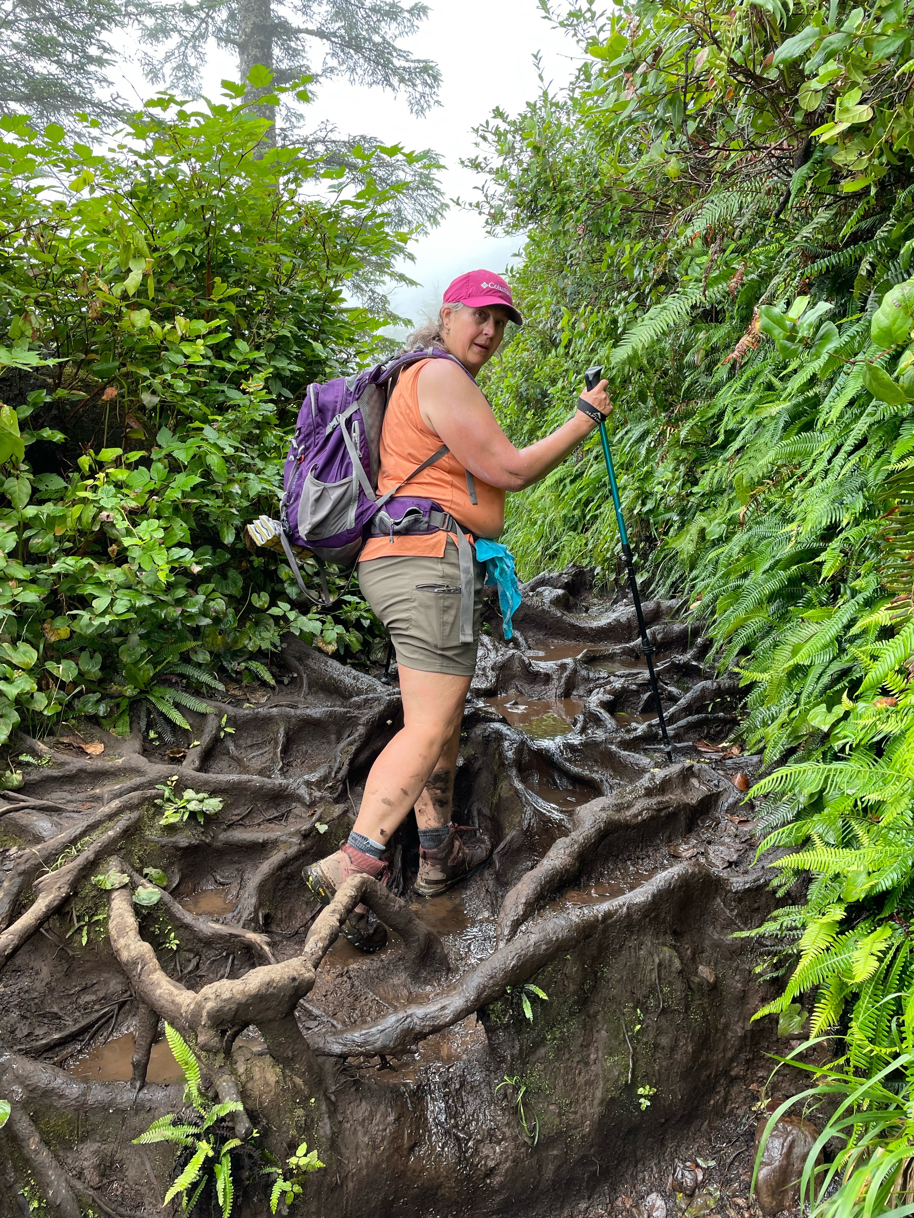
Tree Roots Of Death

The issue turns out to be not so much one of mud, but of mud and water that has been captured by the large spreading roots of the Sitka. These roots form rounded foot size buckets that are distributed across the trail and which you have to slowly pick you way across. Well, if you are an agile youngster or have four legs you can probably make your way walking on the tops of the roots. If you slip off those shinny smooth, polished tops, however, you will go down a 10 inch hole, fall over and break your 65 year old leg bone. This would be non-ideal. 

My partner and I have a mantra for this summer. This is our ‘No Major Injury Summer’. No doing something slightly silly and breaking an ankle or a wrist. No surgeries. No New Knees. We are going to go slowly and carefully through our adventures. Today, this means putting our feet into many of these roundish root puddles. We are both wearing waterproof hiking boots and so doing this isn’t too much of a problem except that you really can’t tell how deep the holes are. Most are like half an inch of mud. But a few are more like 6 inches of mud. The poles come in handy for testing this but I still hit a couple of deep places and got mud almost to the top of my boots. Everyone we met coming back said that there was still more mud ahead of us but that the slug was worth it for the payoff view. 

I was noticing the people that we were passing. They were all ages though mainly over forty and fit. I think it would have been pretty easy for REI to set up a booth and film a commercial out here. Everyone was dressed like an advertisement for the Recreational Equipment Co-op. REI pants and REI sun shirts and carrying REI packs. I was comparing my new REI pack to some of the others I saw on the trail. Mine is nicer. 

Slugging through the mud and root traps is much harder and slower than the level trail. It took us at least another hour to do the 1 mile out to the end of the cape. And more than half of that mile was mined with Sitka Root Mud mazes. I sure hope the pictures can do it justice. As you zig zag back and forth across the now narrowing tip, you have to run into the cliff on the South side and when you do you are rewarded with semi-clear views looking south. You at least have a clear view down down down to the ocean below. We run across a couple sitting on the bluff. They are looking at a Bald Eagle in a tree 100 feet below us. My partner gets a picture. The couple tell us they are also from Portland, escaping the heat of the city. They have nice REI packs.  They also tell us that we are nearly to the end of the trail. We have heard that one before.  However, they are not wrong.


This tip of the trail has a large open space of rock and dirt and a little well worn bench to sit on. There are a few other people out there, everyone is eating lunch. One guy is eating melon and throwing the rinds over the cliff saying, “Oh, the seagulls love these. I do it all of the time”. I really wanted to tell him to quit throwing his garbage onto the cliff or into the ocean. How should one handle a situation such as this? Should I ask him if he is a Republican? I figure if he is a Republican, then I need a gun in order to have a discussion. If he is a Democrat, then I can threaten to report him to REI. ESPECIALLY since he was bragging about how his COSTCO cargo pants were so much better than his REI cargo pants. It is all in the quality of the sweatshop where the clothing is made, you know. You need one that employs very young children because they have the small hands needed for intricate work and you only have to pay them in small balls of rice. Boy, I am a grouchy old man. I can’t wait to get home so I can sit out front and shake my fist and yell “You Kids Stay off of my Grass!”.

So. A quick lunch and then we head back for the car. Turns out that going back the other way is mostly uphill. Just  a little. And uphil climbing through the muddy root traps is suprisingly easier than going slightly downhill. I think this is because you are effectively facing the ladder instead of not facing. (backing?).

That bald eagle is still sitting there in that tree way down there. Oh, and there is a flight of Pelicans!! I have never seen pelicans from so far above them before. Beautiful. 

We make it through the mud with all due alacrity, only stopping to talk to people and tell them how much further the Mud extends. I insist they are halfway through but they insist that is what the last few groups of people told them. 

When all is said and done, my Fitbit says I went nearly 6 miles. Is this because fitbit is wrong or is it because all of those little steps through the mud roots were bouncing me back and forth across the trail? I have this theory that FITBIT is telling you the perceived length instead of the actual length of your trek. Maybe it is the “as the geezer stumbles” as opposed to “as the crow flies”. Either way, I find that with a fitbit, I hike further. So I must be getting more exercise. I need a scale that auto-syncs with my fitbit so my fitbit can convince it not to read so high.