
Angra (Island of Terceira)
 It seems like everywhere you go the tour guide will represent that place as the center of the universe in some small way. Well Angra (meaning small bay or anchorage) turns out to once have been the center of the universe in a very big way. The wind currents of the Atlantic are such that they blow clockwise in the northern hemisphere and counterclockwise in the southern. Back in the 1400 1500 and 1600s, the Portuguese and the Spanish pretty much ruled the seas and they owned the trading routes out to India, the far east, Africa, South America and the Caribbean. All of there ships would go out, heading across with the Northern winds to the Americans, or down the African coast catching the southern winds down around the tip of Africa. Coming home, loaded with treasure and spices, however, everyone was forced to take the Southern winds across the Atlantic South America and then catch the Northern winds across back. In the middle of that slow Atlantic crossing all ships would find themselves naturally at the Azores. Not on could they most easily stop there, they pretty much HAD to stop there because they would be in a bad way for supplies. In those times, on board sickness (I am assuming Scurvy) was very bad and half the crew would often die or be very sick by the time the boats got to the Azores. Because of the placement of the islands in the Archipelago, Terceira is on the same latitude as Lisbon which made it a handy island to steer for (and find using the navigational technology of the day). And Angra is the best (perhaps only) protected port on the island. It isn’t all that big but I am guessing that maybe 10 or 20 of the little ships of the time could lie safely at anchor here. And here they would unload their cargoes, heal up their crew, and/or wait for armed escort from Spain and Portugal to get past the English, French, and Dutch Corsairs. What a great story. I have to find a good historical fiction on the subject. Or write one….

 |
| looking down from the town garden |

 The town of Angra is old. And it has the same street layout as it did back in 1600. Which is wild. Angra means "small stream" or "Anchorage". Our (nice) hotel is on Jesus street just a couple of blocks from the harbor. Hell, the entire town is a couple of blocks from the harbor. This are pretty quiet this time of year but I am thinking the place is pretty rocking once the summer hits. A few expensive looking sailboats in the protected harbor.
We flew in this morning. Our big plane (the 737 class airbus) landed in Ponta Delgada (the capital city of the Azores) where we got on a little plane (2 engine prop with the wheels in the engine housing) and that flew us to the airport on Terceira. From there we caught a tour bus that went the 20 minutes over to the town of Angra. We had to walk a few blocks to our hotel because the cobblestone streets are too narrow for the big bus. Our hotel is very nice and we had a wonderful welcome breakfast before we got into our rooms and had a few hours to try and sleep and recover from the overnight flight. I think we are still recovering.
We did a nice walking tour around the town. Lots of Convents here. In Portugal, a convent does not have any gender specification. A Monastery is a place were religious people practice monastic living (silence, suffering, shit like that). A convent is place where religious people live together cooperatively and are free to leave and reach out to the community. Sounds like a more fun place. They were also associated with things like Education and Medicine.
The buildings here are gaily colored. They are all very old and usually 3 stories tall with nice iron work on the second floor patios and windows. The streets are narrow and paved in dark cobbles with white cobbles used to add art and pattern to the roads and sidewalks.
There are evidently 2 local beers that I have to track down. They don’t have them at the hotel. One is named after a guy that was a local guy that fought with Washington in the American revolution. He was called the Hercules of the Revolution. He had a name that I can’t remember. Perhaps last name of Francisco? Must find out. (I never did get one of these beers. Never found a place that had them)
The other beer was named after a woman who fought off a Spanish invasion by organizing the local women to stampede a large number of bulls through the advancing Spanish army, killing many and driving many into the sea (where they drowned on account of their heavy armor. Conquistadors, don’t you know. Her name was the Portuguese equivalent of Briana. I think it may be spelled the same way but is not pronounced anything like that. Once again more research is required.
History of Patchwork:
The Portuguese have lived on the Azores for a long time. They were settled in the 1400s and there have been settlements (mainly farms) here ever since. Since these are volcanic islands, on the intersection of 3 continental plates, there is not much here in the way of rich minerals. Not silver or gold or nickel or iron or anything like that. Just a lot of the various kinds of lava. Lots of rocks. Under those rocks (or mixed in with them) in many areas is a lot of volcanic dust that has had enough time (oh, a million years or so) to turn into great topsoil (mixed with rocks). When the Portuguese sailors first came here, they were not looking for good farmland. They were looking for treasure. They were looking for gold and diamonds and spices. What they found was a place that they could not loot but did make a great stop-over when coming back from places they could loot. Soon enough, farmers followed the sailors and land development came.


.jpeg)
 |
| These are vineyards. |

So a little summary on the walls. They had 3 main purposes: They gave a place to put the rocks. They defined the borders of the farmers property and fields. They blocked the salty wind from the ocean and kept the crops from being ‘burnt’ by the wind. The blocking effect is about 7 to one. So the one meter wall could protect to around a depth of 7 meters. This lends a natural definition to the size of the fields that one could maintain with such a system.
Whaling:
 |
| View from Historic Whale Lookout point |
 In the early 1800s, whaling was becoming very popular. The Portuguese were active in whaling both by joining with American whalers (mainly hunting the Right Whale) and hunting whales just in the local waters around the Azores. The Azoreans developed their own ways of whaling which involved the opportunistic method of waiting for a close by pod of whales and then hunting them in small boats launched from shore. During the right season, a lookout would be posted on a handy shore side promontory. When he spotted whales blowing he would signal with fireworks (or may cannon shot. Something loud). The farmers and woodworkers and barbers and just everyone would drop what they were doing and run to shore to get in their boats and go hunt the whales. And why? They whales were very lucrative. The oil from the whales was used for lamps. It was also the ‘WD-50’ of the time and was used for the lubrication and preservation of metal components (things like clocks and guns). The Azoreans hunted exclusively for the Sperm Whale and were selling whale oil to the Germans as gun oil even into WWII.
 |
| Rendering Vats |
 |
| Whale Oil Holding Tank |
And they only hunted Sperm Whales. Lots of species of whales around the island, but the Azoreans only hunted the sperm. Why could that possibly be? Is it because of the Spermaceti? The oil rich substance that is found only in the giant head of the sperm whale? Very valuable. No, though that must have helped with the economic value of hunting it wasn't why they didn't hunt other whales. Perhaps that ambergris? The extremely valuable substance that was occasionally found in the whale guts? No again. It was too rare to count on. Then what? Evidently the sperm whale was the only whale that floats when you kill it. They needed them to float so they could haul them by small boat, towing them miles and taking up to 2 days, back to the their shore facilities where they would be winched up a ramp and then flensed and rendered. I saw some of the big pots and ramps at one of the preserved whaling locations that we visited, the holding tank for the oil was Huge. (hundreds of liters).
 |
| There are many depictions of whales around the islands. This guy is hanging from the ceiling of the big mall in Ponta Delgada (Note - The whale is top center). |
Swimming Areas


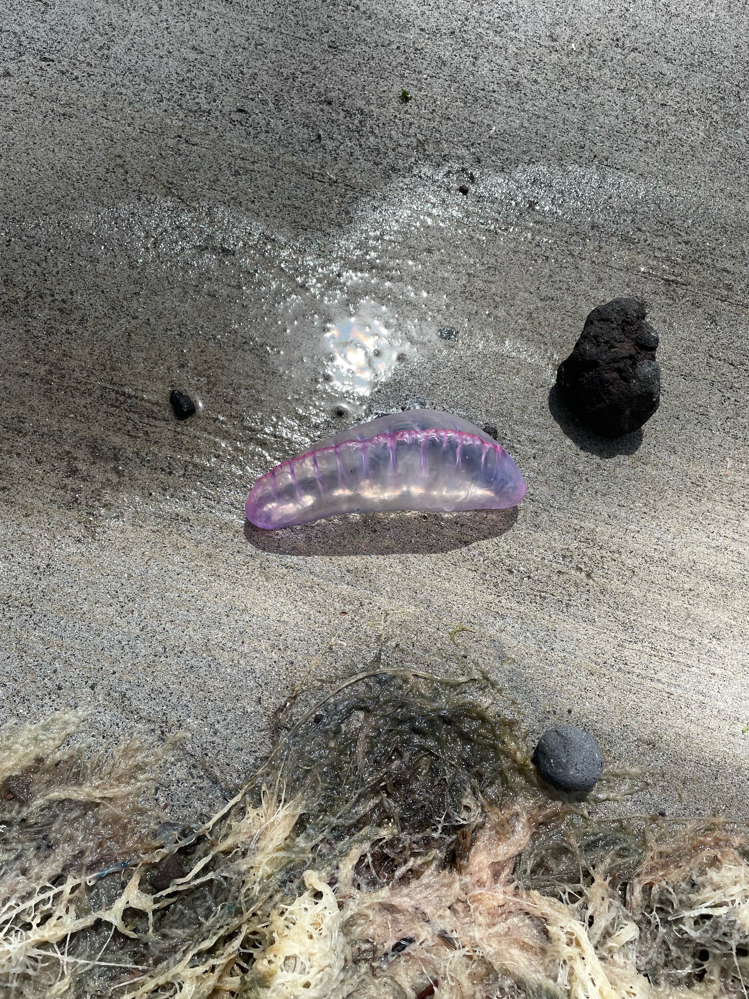 |
| caravel (Portuguese Man Of War) |


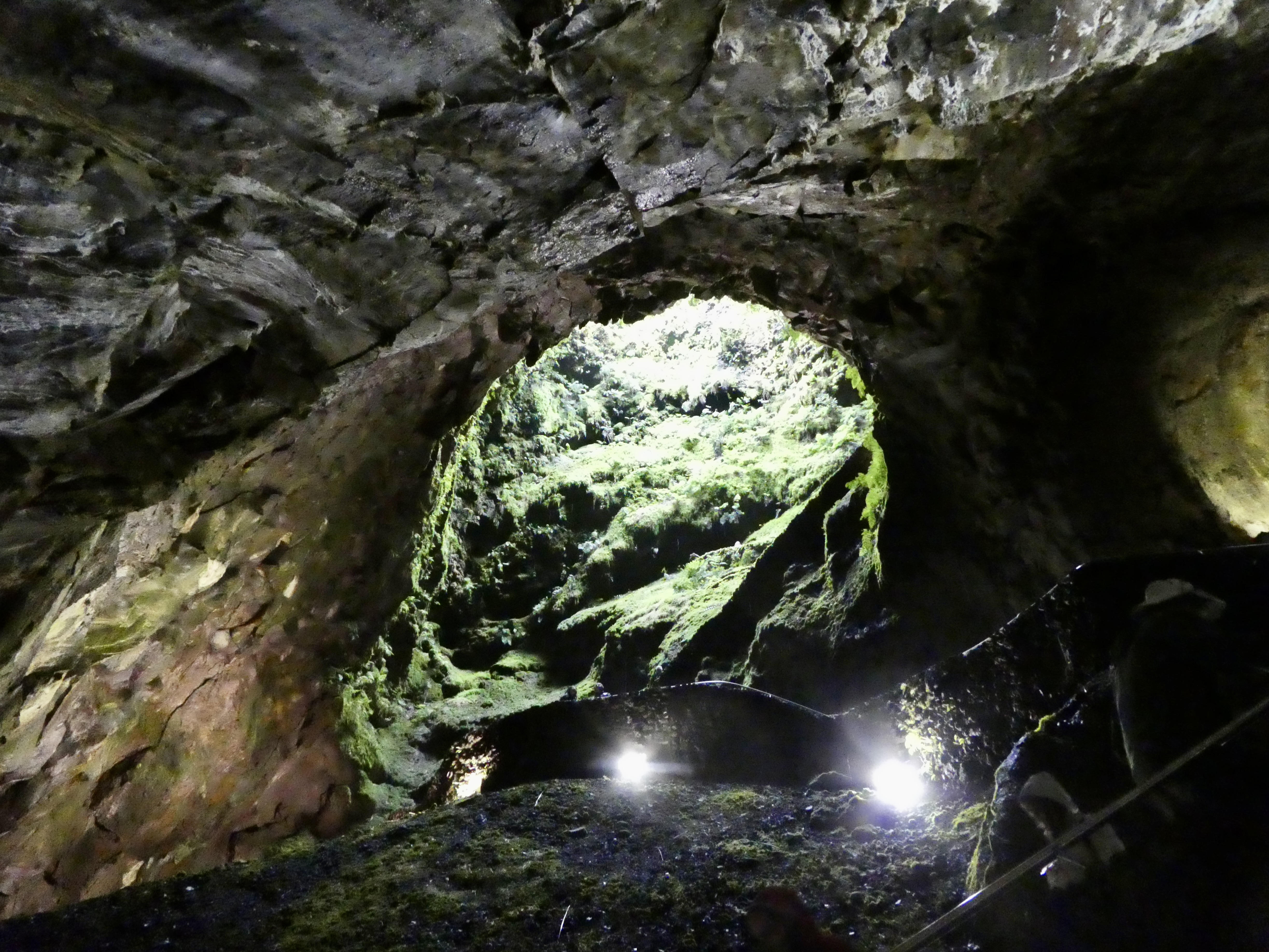
Algar do Carvão (Cavern of Coal)


Mount Brazil
 |
| Mt Brazil as seen from North Angra |

 |
| Looking into the Caldera |
 |
| Angra from Mt Brazil Viewpoint |

 |
| Most sides of Mt Brazil are Sheer Cliffs. This one has an old Spanish Gun emplacment |
 |
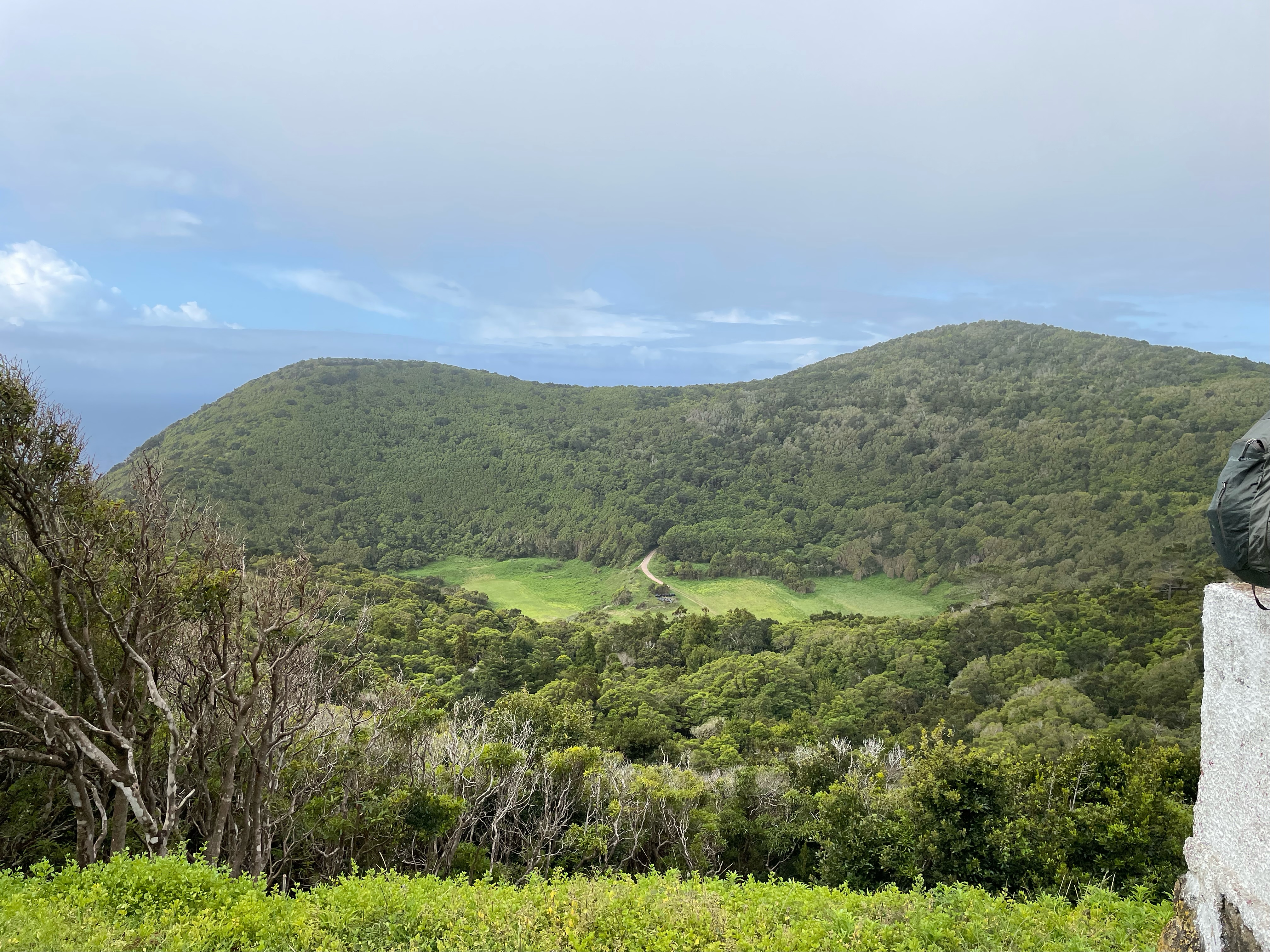
| Much of Mt Brazil is only recently made public. New Trees abound. |
At this writing I am 66 years old and one of the younger people on this hike. Plenty of people over 75. So the tour staff were concerned about getting us up and down this hill. The up part wasn’t too bad, just had to wait for some people to catch their breath. I was only about 600 feet and we did it in 10 or 15 minutes. Now we started around the inside of the caldera. I should say here that our guide told us that the difference between a crater and a caldera is the size. Anything with a diameter over 1.6 Kilometers is a Caldera. I think that when I visited Crater lake they told me that a crater was formed by an impact (like a meteor) and a Caldera was formed by a volcanic eruption. You can choose the answer you prefer.
When we started down the somewhat steep trail into the center of the caldera the staff was extremely cautious. They gave us a 5 minute lecture in how to go down the rock face (use the carved stepping places and turn sideways!!). It was good that they were being so careful to take care of us because many of the people had a really hard time going down. Paige and I didn’t have any trouble and just sort of walked right down (The guide yelled at me a bit, ”No, Sir. You must turn sideways. Sideways. “). The ocean side of the caldera has no high rim but is rather a down slope to the cliffs to the see. At the top of these cliffs was another ancient Spanish gun emplacement. This one would have had excellent views of ships coming in from the south and would have been able to provide good downward fire onto the enemy. Would have been hell getting the guns and shot down that slope, however.
The history and the story of islands just about always talks about the exotic invasive plants and animals that have been introduced to the island. Some of the invasives are introduced intentionally (like the false coffee which is used for windbreaks) and other come over by accident (like the European Rat that went pretty much everywhere European ships went). It seems like anytime a non-domestic mammal is brought over, bad things happen. Take, for instance, the mongoose, that was brought into Hawaii to take care of the rat population. That didn’t work at all and now they have Rats and Mongoose eating all the local birds. One would think that people would learn, but a decade or so ago the parks people here on the Acores introduced European deer “just for fun”. Now the deer have taken off and are making a nuisance of themselves.
Another invasive story that I like: When we were in Hawaii, we were in an area that had some very nice tree cover. We were told that those trees were not endemic and the land didn’t used to look like that and in fact those trees were invasive and were displacing local trees. Well today I find that those trees were imported by Azorean people that immigrated to Hawaii some 70 years ago. So one islands native is another islands Invasive. Why do all plants from other places want to take over a new place. Why can’t they just stay home and be happy.

One thing I have trouble with is trying to remember that, though I am viewing a historic place, it has been changing a lot over the years. For instance, all of the trees that we were walking through that made the area very pleasant were pretty young. 20 years ago the entire area was devoid of trees, not sure why.
 |
| This is a view from the coast south of Angra. Note the Mt Brazil Headland sticking out sharply in the background |
No comments:
Post a Comment