
A few years ago, when I met my kayak partner, I moved a few miles East into Portland city proper. Since then, it has been easier (less commute time) to head up the gorge for hiking instead of out to the coast range. Because of that, I have been neglecting my old haunts in the Tillamook forest. But my partner has set herself a challenge to do a number of “new to her” hikes in 2021 and so she has been looking through the 60 Hikes near Portland book and found the Wilson River trail. This trail happens to start at the same place that the Elk Creek trail starts, so we have been there a few time without actually getting on that trail.
 |
| New Parking Lot |

 |
| First Trillium on stump |
 |
| So Where do you want to go? |
Did I mention that I hurt my knee when we hiked the Salmon river trail in December? Did I even blog that hike? I am so behind.
Anyway, I hurt my knee. Well, I incapacitated my seriously arthritic knee. I am having joint replacement surgery in a month or so and, until then, I am pretty drastically limited in my ability to go up or down hills. I can do a couple of miles on a more or less level path, however, and thus this part of the Wilson River Trail.
The park service has been doing quite a bit of work on the Tillamook trail system over the past few years. They have greatly increased the parking availability at the Elk creek (Wilson river) trailhead and have made that area open year round. They have also extended the trail system East to Idiot Creek Loop Road Trailhead. That trailhead is hard to get to using a 2 wheel drive vehicle (it is out on forest service roads) but you can do a out and back from Elk Creek. They also have a seasonal bridge now across Elk Creek that they put up in the summer and can be used to more easily access the Idiot Creek trail. I had talked to a Ranger back oh…… 10 years ago and he had told me that a nice (expensive) permanent bridge across Elk Creek was planned but they were having trouble getting funding. I had put some effort into doing some fund raising for that bridge but I guess the project got cancelled before I could ever get going because I couldn’t even get a concept drawing from the Forest Service (I sort of figure I was going to need some conceptualization to get Intel (my employer at that time) interested in this sort of community project. )
But, enough of that, lets go on a hike.
To access this location, drive highway 26 from Portland and then follow highway 6 toward Tillamook (city). This will go through Banks and then head toward Gale’s Creek and up over the mountain pass. No snow up there this year, though I could see some white on some of the local mountain tops. This road is called The Wilson River Highway and it picks up the Wilson river just a little past the pass after traversing a high bridge into a lovely Gorge cut by the river. Along here in the spring are lots of little water falls and run offs. There are also a number of forest roads that lead off to places for exploring, hunting, primitive camping, and 4 wheeling. The Elk Creek Campground is on the right just after you bottom out of the steep downhill. The camp is at the confluence of the Wilson River and Elk Creek. Drive down the gravel road toward the campground and just keep going as far as you can. You will cross a bridge over Elk Creek and then head up the historic lumber road to the new parking area and Trail head.
 |
| Looking Down on Elk Creek |
 |
| Up through the Alder |
There are a number of trails to access from this parking lot. Elk Creek Trail goes on up the same road you are driving on (though it is no longer road-like enough for vehicles) until it accesses another old lumber road up on the ridge between King Mountain, Elk Mountain, and the unnamed (and heavily clear cut) hills to the east. A half a mile along that same road and you come to the river crossing that starts the Idiot Creek Loop trail.
Going in the other direction (West) there is a new part of the Wilson River Trail (about 200 yards long) that leads back to the hills above the campsite and intersects with the original Wilson River Trailhead. Now you have your only steep climb on this hike. It goes up quite briskly for a few hundred yards and then flattens out at the official start of the Elk MountainTrail. Elk Mountain Trail is a hell of a climb. It is only 1.25 miles but has over 2000 feet of change. I remember it as walking 20 steps and catching my breath for 2 minutes and then repeating for two hours. Once you get up there, however, you have some great views and also a fun (but challenging) loop hike back over to either the top of the Elk Creek Trail, or the Top of the Kings Mountain Trail. Don’t do this one unless you are fit. I do want to try it again, but I will need my new knee, and perhaps a personal trainer, first.
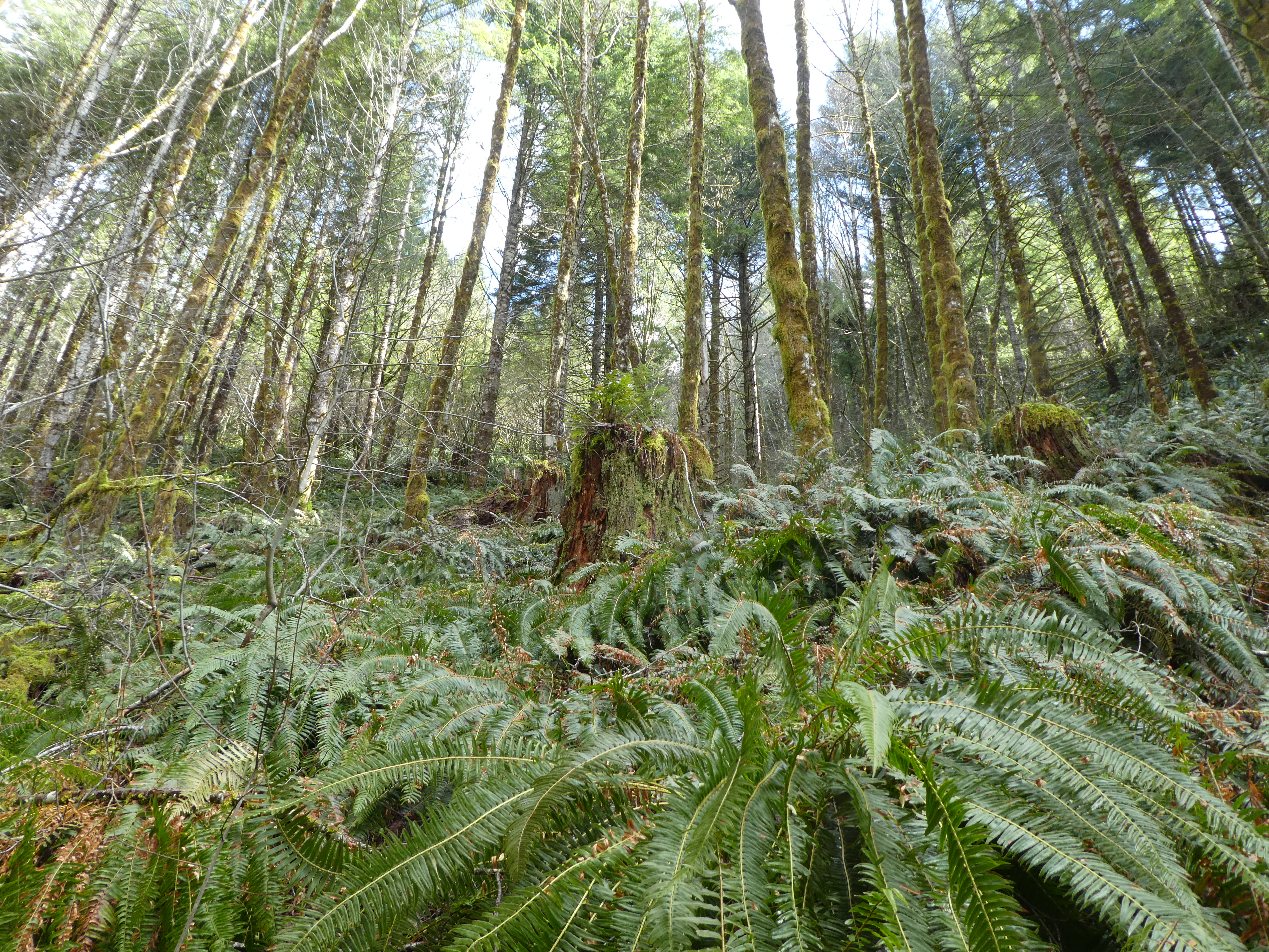
That leaves us with the River Wilson Trail. I have my trekking poles out and we push into it. This trail is really a very beautiful, green, and pleasant walk for just about anyone with 2 knees. The Pacific Northwest forest flora is in complete domination here and is really showing off. The undergrowth is heavy with very large and very healthy Mahonia (Oregon Grape) and Sallal (Not Oregon Grape, though the berries look similar and are equally editable). The spring flowers are just getting started so we only saw a few small things that I couldn’t identify but a there were a few early Trillium just sticking up there heads. The big trees were the usual Doug Firs with quite a few local manifestations of Alder, especially near the many little creeks where large rock falls had pushed out the Firs. Everything was very green, lots of moss and sword fern at every turn.
 |
| I don't know what this pretty little thing is, but it was growing on a stump also (OK, I believe this to be British Soldier Lichen) |
The trail heads slightly up for a ways and then you find yourself advancing along a cliff with rock on the right and a steeply sloped mass of fern and tree on your left tending down to the river valley. This is something that disappointed my partner. She was expecting us to be along the river (As in “The Wilson River Trail”) but for this entire section (pretty much until one gets to the Forestry Center (like 8 miles)) you are up on the hillside and nowhere near the river. It was also obvious that we were up above the road. There was a constant background noise of car traffic.
 |
| A rare view down the vally |


The other thing that was calling my attention was the profusion of large tree stumps. This entire areas was clear cut back a hundred years ago or so. All of the huge giants were removed and they still need a century or so to grow back (note to self: Re-visit at that time). And looking at all of these stumps makes me think about things. Things like “What in the hell were people thinking?”. Take a look at the pictures. These trees were maybe 6 to 10 feet in diameter. They were cut down using hand saws. The lumber jacks would cut small notches in the trees and insert boards that they could stand on to operate the 15 foot long hand saw. They needed the boards to get them up high enough to be above the root mass because that would be too hard to cut through. Once the tree was felled it would be drug, using cable rope and a steam donkey (a steam powered winch) down the hill to the trucks or trains. They may also set up a skyway of cable and lift the trees up with pulleys and sling them down the hill that way. But when they were done, there was pretty much nothing left except stumps and mud. All of the toppling and dragging of the logs would have torn away all of the underlying vegetation.

 |
| Stump Forest |
 |
| See the Notch for inserting a plank? |
 |
| Lots of huge old cut logs tumbled here |
 |
| Ok, this is a better view of the Notch |
The other thing that dragging those logs down the hill, and then on top of one another, resulted in was a lot of friction heat. You know that old trick of rubbing two sticks together to light a fire? That never worked for me, but if you take really big sticks and rub them together using a Steam Donkey you evidently get better results. You get things like Storey Burn and the Tillamook forest fires that burned up huge swatches of the forest almost a hundred years ago. It used to be that all school children in the area were taught about the fires and then went out for a field trip to the old burn sites to plant Doug Firs. I am sure the lumber industry appreciated that effort.


Well. How are we doing on the hike? In a little over an hour, we have made it 1.5 miles and we have come to a substantial creek crossing. I had hoped to make it to Dog Creek (which is the drainage for the valley between Elk Mountain and Kings Mountain) but I wanted to limit myself to 2 hours of walking (my knee gets sore) and this is really a lovely sunny spot in a tumble of big stone and ancient old forest cut logs. Stopping here also avoids the big Down Hill to Dog Creek that I remember. We sat down on a log and enjoyed our lunch in a lovely sun break. As an additional bonus, the cheerful sound of the little creek completely drowned out any traffic noise.
 |
| our Lunch spot |

 |
| Green Boulders |
On the way back we had a couple of views though some tree breaks at the Wilson River Valley going East. All in all a lovely and peaceful hike.
 |
| The side trail to Elk Mountain. 1.4 miles. 2000 feet vertical. Perhaps another Day |
No comments:
Post a Comment