Mt Hamilton.
This is a well traveled hike on the
Washington side of the gorge. You get there by driving up to Cascade
locks and taking the bridge of the Gods (I kid you not) over to the
little state road that runs down the north coast of the Columbia
river. You drive back west past the Bonnevile dam and suddenly, there
is Beacon rock sitting in front of you. Like 800 feet of very steep-to volcano core carved back to its essential hard essence by the
glacial floods 10K years ago. It was originally name by Lewis and Clark. Actually, they called it Bacon rock, just as a joke, but later Cartographers with no sense of humor changed it to Beacon. The same thing happened to Rooster Rock.
And just to your right, is the access
road to the Trail Head for Mount Hamilton. Here is a picture of Beacon rock and Mt Hamilton as seen from Horsetail falls:
We will do Beacon rock another day.
Today I am a little apprehensive about getting over Mount Hamilton.
The last time I tried I just couldn't do it. Of course, I had done
sentinel rock first. Today I am carrying light. Mainly just water. I
have my trekking poles. But I didn't get a early enough start. It is
the 4th of July and people are EVERYWHERE. The traffic was
backed up onto the interstate when I passed the Multnomah falls
parking lot off of 84. But I guess the $1 charge for Bridge of the
Gods and the (very strictly enforced) $10 fee for a Washington park
has kept the Oregon natives at bay. I still had to park in the upper
lot (another half hour and that would have been full).
The first part of the trail is through
an established forest. Some huge downed trees and such. But the going
is not too steep and the air is cool. You get a first view of Mt.
Hamilton when you break into the sunshine and cross a power lines
right of way. You can see down the lines to the generation plant at
the Bonneville Dam.
 |
| No idea what this is called. But there it is. |
 |
| Stump CAM |

 |
| Power lines. But I am going to climb that puppy. |
The trail still stays pretty flat and
you weave in and out along some little valleys until you come to a
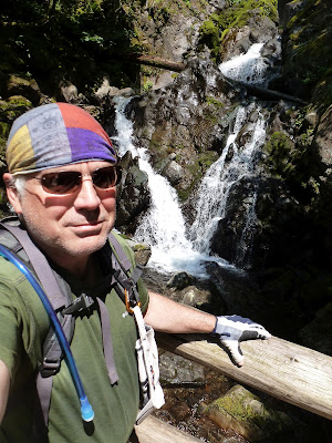
very nice little falls on Hardy Creek. This particular falls has a really cool little down draft through a shaft that looks like it is completely enclosed (until you get into it). I think it is called the cave of winds.
 |
| Indian Pipe. Pretty Rare |
 |
| wild Strawberry |

 |
| Ah, Pool of the Winds !! |
 |
| Some guy on the Bridge. |
Down and up through the
creek and you start your real ascent.
This means things start to get
hotter, you start to get some great view back down the river, and the
Poison Oak starts to show itself.
Some trails in the gorge have the
Poison Oak just at the trailhead, on this hike you have to stay alert
pretty much the entire hike. Don't Wear Shorts !! It was tearing me
apart to see all of the young women (ok, and men) in shorts and low
socks. Please, Mr. Poison Oak, jump out and get me ! Please !!
But it doesn't seem quite right to run
up to every person and grab them and yell, “What in the hell do you
think you are doing? Are you out of your FRAKING MIND?”.
So..... I didn't do that.
There are actually 2 ways up to the
summit. The back way (labeled Difficult) which goes up the hardy
creek valley and then up a road a finally back to the summit down the
ridgeline, and the front way (labeled More Difficult) which goes
straight up the river side of the cliff. With lots of switch backs
and big rock steps.

I took the more difficult way (on
advice from another hiker, who I think went the other way). And you
know what? It wasn't that hard. Either the hill isn't as big as I thought or there every weekend hikes are getting me in shape. AND, I got some killer views of the
river and the gorge.


 |
| That is Beacon Rock from up high |

I also saw to types of wild onion, a
whole lot of tiger lily, and many other flowers that I am still
working on.


 |
| Stone Crop |

There were a LOT of good views from the Switch Backs:
 |
| Look at all of that cool broken rock. |

There were a lot of people on the trail
and like 20 people at the little summit area. One of the things I
like about people being around is that ANYONE will gladly take your
picture for you. Such nice people, hikers are.
 |
| The snow is mount Adams. |
 |
| Mt Hood was obscured. |
I went back down the back way. It was
the right thing to do. It was a bit longer, but had some additional
views and I like walking along a mountain ridge. Not as much poison
oak, either. But it was still there. Watching. Waiting.
 |
| This path is more overgrown. But with Thimble Berry |


Hey, I took this picture back at the
little picnic area right next to where I parked my car. There is a nice paved path all the way to the top of Beacon Rock. Perhaps next week.


No comments:
Post a Comment