Ramona Falls Revisited

It has been a few year since I hiked Ramona Falls. For those of you not in the know, Ramona falls is a wonderful "Wilderness" area hike on the East side of Mt Hood that is one of the most popular go to hikes for the Portland area. I haven't been recently and one reason was that the park service stopped maintaining the seasonal bridge across the Sandy River. The place you cross the Sandy is just a couple of miles away from the headwaters of the Sandy at the Reid Glacier, so it usually isn't a huge expanse of water this late in the summer, still it isn't a trivial crossing for an old man with bad knees and a pack. This year there were a lot of random dead fall the crossed the creek and most people were walking across one of these (it even had a low little handrail that looked like someone had rigged up). My partner went across it easy enough. She even carried my pack across for me. I thought I might just put on the sandals I brought for the purpose and walk across thought the running water, but I just wasn't sure I could do it without taking a swim. The hillside is steep there and the water is moving fast and the water is very silty, you can't see the bottom. I ended up being shamed into crossing on the log.
But why is the bridge no longer maintained? It used to be a simple little bridge. A couple of 2x8s and some planking, maybe 10 foot long. no big deal. Did they really run our of money for it? I mean, during the summer weekends, the Trail Head parking lot will have upward of 100 cars in it. Perhaps they are trying to limit access as opposed to promoting it. They certainly have a number of swift water warning signs put up all over the place. Seems like a boy scout troop, a couple of axes, and a weekend couldn't but help ending in a nice bridge each spring. It turns out that a few years ago some people were crossing the bridge right after a sudden rain storm. The stream came up and swept a guy off of the bridge and he drowned in the river. I can see how it would be easy to drown, by the way, the river is surely gong to knock you off your feet, and everything is rocks to hit you head on. So, no bridge because of legal liability? Because it has GOT to be more dangerous to cross the river the way my partner and I (and everyone else) does.
 |
| The old bridge from a few years ago |
 |
| River Crossing Warnings |
 |
| The terrain before the River |
This year the river crossing looks like this:


There is an absolutely beautiful view of Mt Hood up the river flood plane once you get across.

This is one of the things to see in the area; the interesting geography. I had mentioned (and you can see in the photos) that the river is very silty. I believe this is because the water comes off of the Reid Glacier and the ice that calves off the end of the glacier is loaded with silt that has been picked up as the glacier slides down the rock face of Mt. Hood. But this sandy silty stuff is everywhere in this little valley. I believe this valley, this extended river flood plane, was created by a pyroclastic flow coming down from the mountains (here is a video of something like it):
So the flow comes down. Kills everything. Leaves behind a thick but undulating layer of ash and rock. Then the glacier builds up and as it melts it cuts the river valley. Vegetation that can grow on thin soil with little (retained) water grows over most of the flow. Some willow and alder down by the river, other places scrub pine and rhododendron. Then a little side creek flows over the cliff face creating Ramona Falls. It flows through this white dry valley, hugging the huge wall cleft for a bit, but then drifting out through the middle of the valley bringing this narrow little belt of green most and big fur trees with the supply of water.
That is what you see as you explore this lovely and unique little valley. I especially love the part of the hike from Ramona Falls down along Ramona creek, where the white dirt and low trees give way to the green ferns and bunchberry and large firs that grow close to the Ramona river.


So during the hike, if you go counterclockwise around the loop as we did, you are going to see first the scrub pin forest, with views of the deep Sandy River cut. The tiny little Sandy is gurgling away down there. You can see evidence of seasonal high water down there in the river canyon; dead trees pushed around and dry channels dug. This leg of the hike is a hundred feet or so above the river and stays pretty close to the steep cliffs of white dusty sand that go down the canyon. You hike around 2 miles and ascend around 1000 feet, and then make a left turn and wind your way through the rhododendrons for a few minutes before you come suddenly on a case of big firs with a rocky cliff facing on one side, down which cascades the Ramona river. What a gorgeous little falls. This is the ideal place to eat lunch, just pull up some boulders at the feet of the firs and enjoy the cool shade and the sound the view of Ramona Falls.
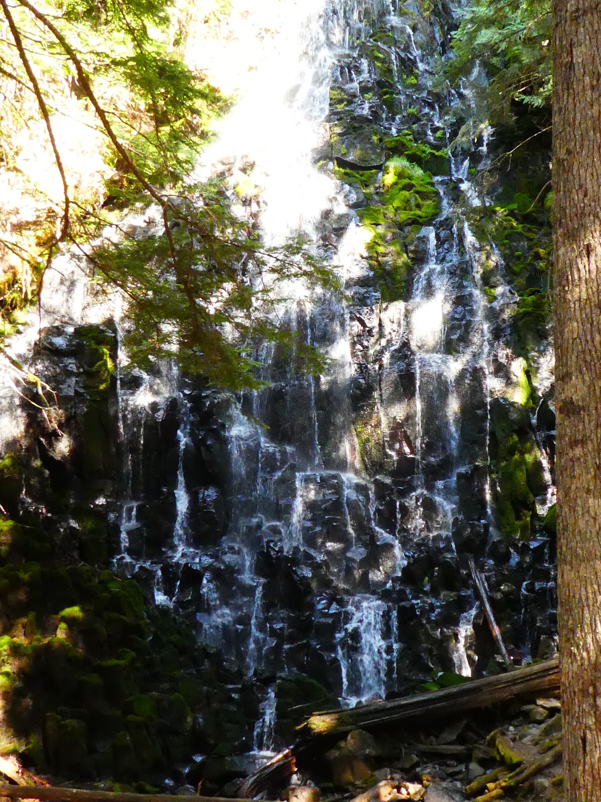 |
| Hard to take pictures of the beautiful falls, the Sun and Shade fight me |
 |
| Our Lunch Spot |
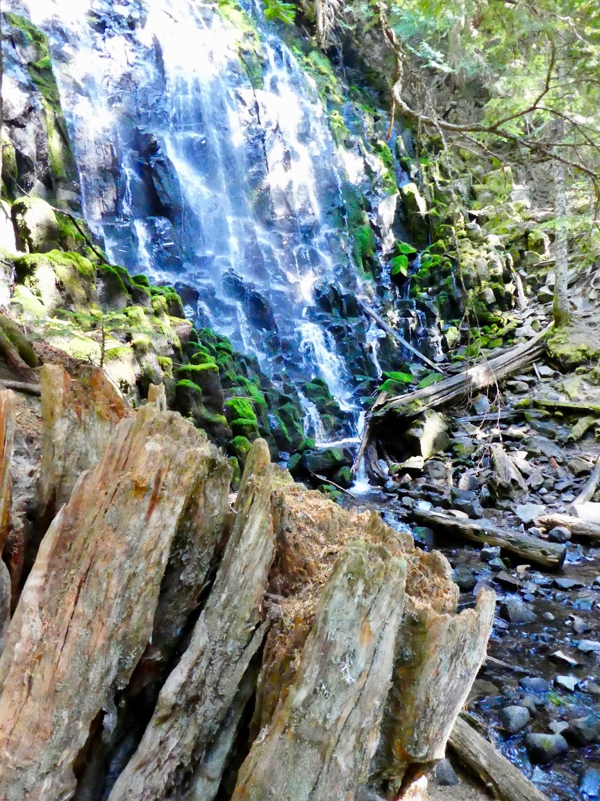
On leaving the falls you cross a bridge at their foot and then turn left to go down the Ramona river trace. This is that lovely green section. Towering fir and Maple for trees and lots of fern and bunch berry for ground cover. And this lovely creek digging a deep little furrow right through it. The furrow of the creek really is quit unusual. Other creeks like this would have deep canyons all around them, but this little guy just has a 5 foot cut he has made. What is that? Is this a relatively new creek that just got diverted over into this area? Perhaps there is very hard rock right under the white dirt we walk on in the dry sections of this valley? I am researching but no news right now.


 |
| Bunch Berry |


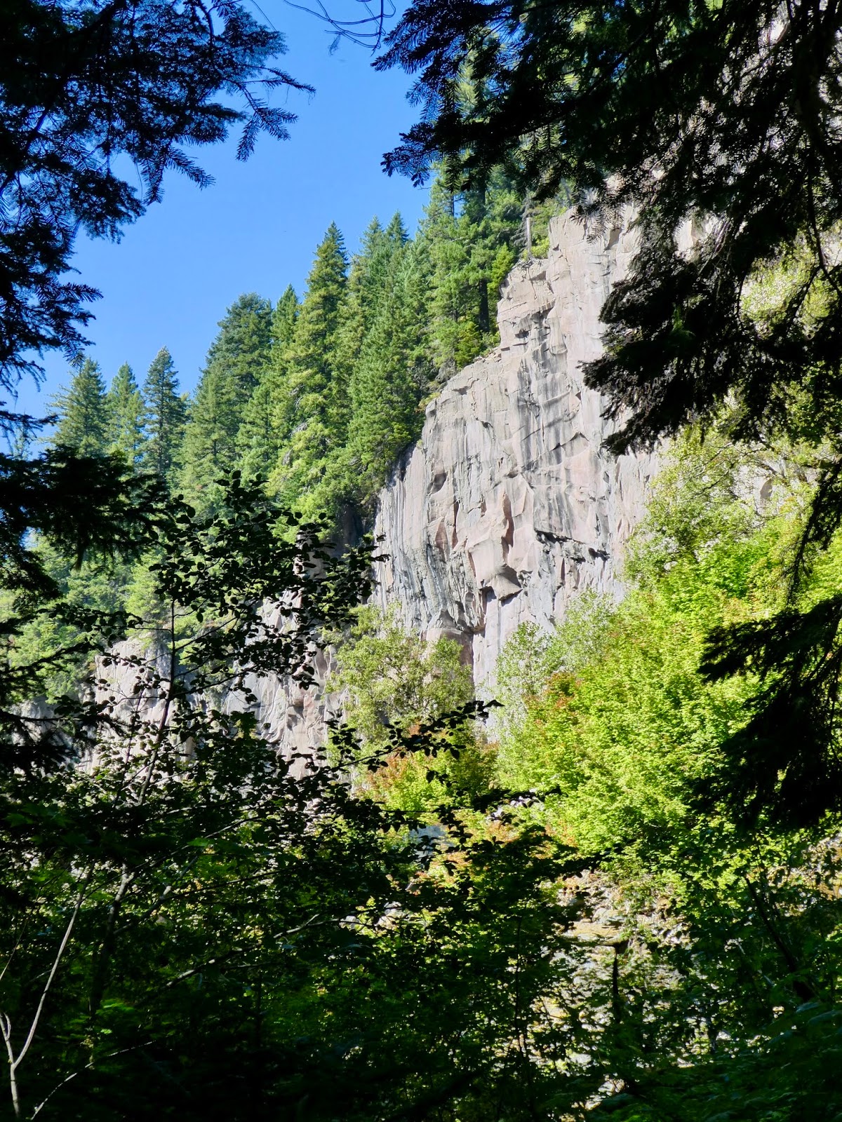 |
| These Cliffs follow the trail for a ways. |
And now a precautionary tale.
We met a couple a the falls whilst eating lunch. They were a few minutes behind us on most of the way down the return trail but then passed us at the intersection for the trail back to the "parking lot" and the one going the other way. We met up with them again just a short way from the crossing of the Sandy. They were consulting their smart phones and their paper map and trying to figure out where they were. They had parked their car at the lot but this return path just didn't seem right to them. The person with the map was pretty certain that she had followed all of the instructions for hiking the trail. In fact, she was following the same instructions as we were, and since they were in the same place as we were, it seemed likely that they were fine. But the description they gave us of where they parked and how far they had walked before they crossed the river (3 miles) must didn't jib with what we knew (and had scene) about the trail. It soon became apparent they they were lost and didn't know how to get back to their car.
Well. No problem. We told them to tag along with us and we would get them back to their car (which they knew to be at the Top Spur trail head, though none of us knew where that was and none of us had a map with that trail on it). So we crossed the river together and had a fine chat with them. It is fun to meet people on the trail and certainly gives one a nice feeling to be able to help someone out from time to time. I also got to give them a lesson. My safety talk.
It goes like this: When I go out hiking, my assumption is that I am going to fall down and break my leg. I won't be able to get out under my own power and I am going to have to survive in place until help can be found to get me out. When I hiked alone, I used to carry a satellite message device (a "find me spot") so I could call for help (maybe). But now I have my partner and she could go for help. So still. I assume that I would have to spend the night. I have a little tarp (this one) a emergency bivioc bag (this one). I usually have extra water and I have tablets for purifying more water. I have a few emergency bars (like Cliff bars). I usually have a raincoat and I always always, even in the height of summer, carry a fleece. I often feel a little silly having all of this gear, but I content myself on thinking how silly I would feel if I broke my leg and didn't have it.
On this hike and many other hikes out in on Mt Hood, you are entering into a semi-controlled wilderness designated area. Your cell phone probably won't work. If you are deep in a canyon your emergency sattlelite link may not work. You have to be prepared to take care of yourself and be able to orient yourself to get out if you can or have to.
So. What happened with our lost friends? They did a few completely reasonable things that added up into getting them very lost. First: They went out and got hiking directions. These are written directions that get you from the parking lot to the falls and back. The same directions that we used, it turns out. Then they asked Google to give them driving directions to Ramona Falls. Sound reasonable? The deal is, if there isn't a road to a place, Google will give you directions to the closest trailhead to the destination. Which isn't necessarily where you want to go because closes is "as the crow flies". In this case, it took them to the Top Spur Trailhead. Now, this sounds like a great hike to do sometime, but it isn't the easiest way to get to Ramona falls. It sort of climbs up the mountain and then comes down to the falls on a trail that we passed but didn't use. The funny thing is, however, that if you read the written hiking directions just a little wrong, you can convince yourself that the trail from Top Spur is really the trail from the Ramona Falls Trailhead. I mean, you hike a ways, you ford a river (the Muddy instead of the Sandy) and then you hike some more following signs to Ramona Falls, and then you eat lunch and then follow signs to the parking lot and then you find you are 10 miles away from your car. Just like that.
So. We gave them a ride back to their car. And we decided to make sure we had better maps for the next time we were out in the wilderness. Perhaps I should renew my Spot membership...
|
| A final view of Mt Hood before we cross the Sandy. |
This is Superb. I am big fan of Oregon countryside and I want to tell you how much I appreciated your clearly written and thought-provoking article.
ReplyDeleteThanks!
Thanks for your comment. Glad you enjoyed the post.
Delete