Friday, December 31, 2021

Edison Butte Snow Shoe


Edison Butte is a snow park and trail head on Mount Bachelor right off NF-45 which is the main drag from Sunriver to Mt Bachelor.  The Butte itself is just across the road from the parking lot and trailhead. During the summer, this is a hiking trailhead and OHV area. During the winter, when the snow has coated everything with a layer of white fluff, it is an excellent destination for Cross Country Skiing, Snowshoeing, and other snow-based fun. 

We have been staying for a few days in a rental in Sunriver, a sort of up scale outdoor adventure oriented community. Lots of snow covered bike paths and such to walk or snowshoe on here, but we wanted to venture out some and so we headed a ways up the mountain to find some excitement. Forest Road 45 starts just outside of Sunriver (near the bridge across the Deshutes River) and goes in pretty much a straight line right up the mountain. On Google maps, the road is occasionally labeled "Edison Ice Caves Road", which is interesting. There is also a Edison Ice Caves labeled on some maps not far from the Edison Snow Park. An ice cave is a lava tube that has had a ceiling collapse leaving an entrance from the surface. They are called ice caves because ice and snow get into them in the winter and pretty much don't melt even late in the summer. So you can hike into them and find the ice (or at least find them very cold). The largest publicly known lava tube in this area is a national park site and you can go there and park and rent a lantern and hiking the 2 miles down the 50 foot diameter tube to the sand filled terminus. Why this digression? Because the presence of a lava tube is also indicative of other big surface rock formations. Some of which we will see whilst out Snowshoeing.

Cars at the Trailhead

We get to the Snow Park around 10:30, which is evidently pretty early to be arriving because the parking lot is only about a quarter full (when we left, it was at capacity).  The temperature is a balmy 28. Yesterday it was 12. We lucked out.

The map mounted on the trail complex entrance tells a great story.  First, note that there are 2 kinds of trails, those for Snowshoeing (or just walking) and those for Nordic Skiing. The Nordic Ski trails feature 2 tracks (one for each ski) and go around through the trees and stay away from rocky areas. The Snowshoeing trails have one well tramped 2 foot wide path going off through other interesting areas. 


The other thing you notice is the cute trail names. Since this is Edison Butte (which I am betting has nothing to do with the inventor) many of the trails have electricity based names, like "Direct Current" and "High Voltage". One of the snowshoe trails is named "Tesla". I find this funny because the stories of Edison and Tesla always imply that they didn't get on so well. 

Today, one of our party is going out to Cross Country skiing, so she is leaving us. My partner and I are going to do one of the descriptively named snow shoe trails "Long Loop" and "Short Loop".  They should have consulted with a few more electrical engineers on these names. I think they easily could have called "Short Loop" the more apt name of "Short Circuit".  

These two trails start off together, so we decided to put off making a decision as to which one we were actually on for as long as possible. Our main concern is that we are meeting our Nordic Ski friend back at the car in 2 hours. Short Loop claims to be 3 miles. Long claims to be 4.5 miles. 

We tramp along. Everything has had a recent 6 to 12 inches of new snow (like in the last 48 hours) but the trails are well marked (with blue squares with little yellow snow shoe people nailed up high in the trees or on posts) and well tramped (by previous shoers).  The trail starts to wend its way through  an area that must be a tumble of boulders or lava rock uprising. It is hard to tell because of all of the beautiful snow. But the trail goes up and down and in and out in a maze like fashion and the view of the snow covered rock piles is stunning. 


Our other stark vista is the red/orange giant of Ponderosa Pine soaring up through the snow and towering over the smaller lodge pole pine. I think I got a couple of good pictures. 
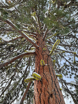
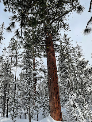


Ponderosa


Quite a few other hikers on the trail, many of these with dogs. Just about everyone is going much faster than we are. I could attribute this to my still recovering from knee surgery, but I think I will instead go with the fact that many people were wearing smaller and lighter snow shoes. More like wearing large tennis shoes. This has got to be cheating. I have to look into getting some of these things. My partner and I are wearing the $65 specials from Costco. They work fine. They get you up and down the hills and you can tromp off trail into the deep snow without sinking in over your head. But they are a lot bigger and heavier than what many of the fast movers around us are wearing. 


The weather was pretty variable for our short time on the mountain. It snowed pretty hard during the drive up, but just after we passed the sign to "Chain Up" the snow stopped and the sun came out and it was pretty nice there in the parking lot whilst we geared up.  We got a little snow before we got to the trail decision point but then the sun came back out again. Now we came to a big Ponderosa Pine with a trail map on it. We could go straight and be on the long and short loop, or go right and only be on the short loop. My partner pointed out that we had to pass this tree again to get back to the car. Nice to know. We realized we could go straight and once again avoid having to make a decision about going the short or long route. 


Back into some even more intense rock pile areas. These were a little challenging to get up and down (at least for a 65 year old with a new knee). After another quarter of a mile we came to our real decision point. Long loop was about 3 miles back to the car. Short loop was about 2 miles back to the car. We had come about half a mile and used up about 40 minutes and were already feeling the burn a bit. We decided that we needed to take the short loop to be back on time. This turned out to be a good decision.  We now hiked away from the bolder fields and through some lovely trees, crossing a Nordic trail track. We were heating up some and stopped to lose a layer. We usually carry small packs when we go snow shoeing. I liked to bring some extra layers (rain coat, fleece, dry socks, thick gloves) as well as water and some emergency gear. My usual thought is that I want to be able to spend a few hours (or a night) in the snow in case I fall and break a leg or something like that. Even if you don't want to carry the emergency gear, it is very nice to have a place to put your layers as you heat up or cool down. 


After about half an hour we got to the place where the long loop intersects with the short loop. We were a mile and a quarter from the parking lot, had been hiking for an hour, and were halfway around the loop. Wow. that is pretty slow. It turns out it is much harder to walk through snow in snow shoes than it is to just go out for a hike in the forest. We turned down the trail back toward the trailhead. We pretty much immediately hit a bit of a slug uphill and at the same time, that beautiful sun disappeared. It started snowing rather hard and the cold wind was blowing. We stopped at the top of a rise and got our outer layer rain coats back out and put them on to stop the wind and snow.  At this point I was glad that we had taken the short loop. Not only was it shorter, it was also labeled "More Difficult".  Why is that good? Because the long loop was labeled "Most Difficult" and I was having enough trouble with some of the steps up into the boulder groups on the "More Difficult" path.   I also find it amusing that the "More Difficult" route is the less difficult route.

The snow flurry did not last long. The sun came back out and we finished our hike with the sun shining. What a glorious day.


Thursday, November 11, 2021

Springwater Trail Corridor

link

 I love to travel on old railway right of ways (rights of way?). Now, sometimes this means hiking on an actual railroad (link) and sometimes this means traveling on a paved Rails to Trails project (like the Banks to Vernonia Linear Trail). Many times the fact that you are on an old railway can be subtle because the right of way was long abandoned before being reclaimed. A good example of that is the new Urban Red Electric line that is going up in Portland. The marked trail is squirrely because so much has been appropriated by neighbors over the last century and is now "private" land.  In other cases, however, the trail is well preserved and you can see how the railroad engineers changed the landscape a century ago to put in the railroad.

There are 2 main aspects that control the physics of railway design.

1) Wheel base width. You need to space your train wheels (side to side) enough to give stability to your load. The closer the wheels are together, the less stabile your load and the more concentrated the load weight is on a small section of ground. However, the spacing of the wheels directly impacts how tight a turn a car can make. The bigger the spacing, the less the turn can be. For standard gauge this forces the turns to be rather gradual. 

2) Wheel Friction. There is very little friction between steel wheels and steel rails. This lack of friction is what makes trains run smoothly and at relatively low energy cost. It also directly limits the grade on which an engine can pull a load without having its wheels slip. This means that a train track wants to be relatively level. To do this through hilly terrain, the tracks will snake around a lot, but you will also see where some hills have cuts through them and some valleys were filled with that cut-dirt to create a generally level roadway. (There is a big section of our trail today that goes through such a cut. But I am getting ahead of myself. )

Today my partner and I took advantage of a break in the autumn rain to do a bike ride down the Springwater Corridor Trail. This trail is 21 some miles long with one terminus in Boring and the other in downtown Portland near OMSI. Except for a quarter mile blockage (where you have to take to the city streets) the entire line is old railroad right of way and runs straight and level and paved. A 50 foot wide strip of green that stretches East from downtown following Johnson creek into the nearby forests (now nearby suburbs).


When the trail was originally converted, quite a bit of money was spent as there are nice bike/walk bridges that go over the major roads and canyons that are close to the city.  You can zip along on the 2 wide paved trail and be above the traffic and get a nice view of the surrounding city and suburbia. 


Bridge over 99(?)


You see things on a bicycle that you might not notice as you speed by driving your car. I had no idea, for instance, that Johnson Creek was so large and so prominent as it winds its way through SE Portland. I sort of thought it was some paved over sort of thing, but, at least during these heavy rains, it is a big and flowing waterway with plenty of trees surrounding it. We crossed the creek a number of times as we headed East. 

Pendleton Mills

We saw a couple of Urban things of interest. One was a Pendleton Woolen Mill outlet. This is a old Mill (I don't know if it is still operational) where Pendleton blankets and such were (are?) made. But more important, a store where you might find 'bargains'. I really like Pendleton blankets (though it is true that you only need so many). They are usually a little pricey, however. You can find seconds at these outlets that might be a reasonable price. Especially if you want a University of Oregon Orange Duck blanket with a big blemish! 

The right of way gets off the creek for a while as it goes past Tideman-Johnson nature preserve and runs parallel to Johnson Creek blvd. It then comes to a large intersection where the trail crosses diagonally through the intersection. The city has put up a nice (automatic) bike signal here. Just pull up to the green marking on the path such that the "bicycle detected" light turns green and wait for a green bicycle crossing light across the way and off you go!


And right there was paused for a moment to put on gloves (it was a bit nippy) and while we stood, 2 car carriers (one full, one empty) drove past us into this business that sits on the corner. This was a HUGE building and holding yard that seemed to be full of cars. The logo over the entrance had a gavel and I was wondering it if was a impound lot. My partner pointed out that it was probably some sort of auction facility.  They turn out to be a place that specializes in getting cars (from individuals? from where is unclear) and doing repair and cleanup and then auctioning them off to car dealers. There is an auction every Wednesday, which you can attend online, but it would be more fun to take advantage of the free breakfast! They talk about having 8 lanes of sales, which I imagine is some car auction talk. I wonder if I can attend an auction just to watch and perhaps write about.

Now we come to a somewhat sad part of my story. All along the trail, from the start downtown, to out here on the edge of Gresham, we have been passing various little homeless encampments. The first one we passed today, which was under the Selwood bridge, we a 30 foot long burned scar. But everywhere there are actively in use tents or just abandoned trash heaps. You don't actually see to many people in the campsites, they may be off  scrounging for the day. (OK, scrounging seems like a strong word with a lot of deprecating meaning. But I am going to keep it as I believe it is accurate as can be seen by the items that are in these encampments. They are just odds and ends that were "found" and scrounged for camp use). Often the camps are off trail and hidden down in the cane breaks of blackberry. But other times they are overflowing onto the trail. There are fire pits and propane stoves. There are little 2 man pup tents and huge 8 man camping tents. There are now cars or RV (which you often see at camping places in the city) because there is no way to get the vehicles onto the trail. There was at least one place that had a stairway leading down to it and had a few plywood walls and a scanvenged house door. 

though I didn't take any campsite pictures
intentionally, it is hard to avoid completely
as they were endemic in the region.

Many of the little encampments seem to specialize in some little business activity. Here is a place with lots of bicycle parts, wheels and such. He seems to be fixing bikes and making stuff carriers for use on the trail. Here is a guy that is collecting motorcycle parts. Is he fixing up a motorcycle? Perhaps. 

And nothing is neat. There is trash everywhere in every encampment. I believe that when it gets too trashy, the inhabitants just move down the trail and leave their trash. Though I did a few people picking up trash and transporting it someplace. And then the big question for me: Human waste. There are no port-a-poties or restrooms out there on the trail. Where do these people poop and shower? Where do they get potable water? Where do they safely store food? This is not a healthy environment. And I did see several encampments with children toys prominent. Sigh. 

You may note that I don't have any pictures of these encampments. One reason is that I was on a bicycle and it is a little hard to stop and photograph. But also it just didn't seem right to be taking pictures of these people and their situation. It would not have been appropriate. I may even have been a little scary.

How does society deal with this sort of thing? I believe the problem to be prevalent across America. I believe that everyone would like some solution. Here in Portland they do clean ups and they move people from their encampments, but that just pushes them off to another location. They are trying making some designated locations, but that isn't something that many of these campers are looking for. Clearly a solution is needed and money must be spent or we are going to have our beautiful parks and byways and biking trails destroyed by this behavior.  Double Sigh.

405 Trail Intersection


Mt Hood. Nearing Powell Butte

Ok. We finally get far enough from the city that the camping stops. We get all the way out to Powell Butte. We could have ridden our bikes up the trail from the back entrance to Powell Butte (the old couple on the Max Offroad eBikes certainly did) but we aren't off road riders. So we stopped and had a snack and then turned around and pedaled back. Turns out that we had been going slight uphill and now were coasting back to Portland. 

Johnson Creek 


I got distracted. I meant to mention the Good parts of this trail. It connects together a number of city and county Parks. It also connects to the 405 trail, which is a multi-use trail that follows under and beside the 405 interstate and connects up the Marine Trail that goes along the Columbia river. This, in turn, travels up to trout dale and would allow a cyclist access to route 30 and the biking trail up the gorge. So a lot of possibilities for full day excursions in the city. My next big challenge: learning how to safely get from my neighborhood down to the Willamette river. Perhaps on the next sunny day.... which may be in April.


Monday, October 25, 2021

Snow Shoes from Government Base Camp


At one time, Government Camp, was just a regular campsite on that part of the Oregon Trail called Barlow Pass (or the Barlow Road). When a huge wagon train (several hundred wagons) of the Federal Army was forced to leave a cache of supplies at the location, the locals took to calling the location “Government Camp” and the name stuck. Now-a-days it is an unincorporated area with a post office, a few eating establishments, and a bunch of condos and ski shops.  We are staying at Collin’s lake resort Grand Lodge. This is right off of highway 26 and a really (really) nice set of condos built around a little lake and a beautiful stand of fir. 


We are using the Grand Lodge (which is really just a big hotel building with nice condos instead of hotel rooms) as our base of operations and are planning little snow outings every day.  When we originally planned to come up here was a couple of days after the big ice storm that Oregon had in February. The power was off all over the place including Government Camp. Collins lake told us 1) The power is off, 2) it won’t be back on soon 3) You can’t come up here (travel restrictions) 4) We won’t give you a refund.


But they did let us reschedule. We weren’t really sure if there would still be decent snow this late in he season, but Surprise Surprise, we had snow falling on us as we drove into the mountains !


Now, if you are a big time adventurer or sports enthusiast, you can come up to Government camp and then access the downhill ski areas (Timberline, Skibowl, summit, or Meadows) or any of the many cross country trails (like those to Trillium Lake or Barlow Road). If you have kids, there are many hills to do sledding and such (I like White River snow park, but there is a rope tow over at Skibowl and a dedicated tubing area). There are also lots of little sled hills around including one on the edge of Collins Lake Resort.  My party (me, my partner, and a couple of our sisters) have older knees and stick mainly to snow shoeing as our winter sport. There are many nice, scenic, and easy to access snow shoe trails around government camp. 


Crosstown Trail

This is just a little trail that is up behind town in the woods and goes from the East side of Government Camp (at the little Summit chair lift) to the Glacier View snow park outside of the west end of town. There are a few connector trails that come up out of town and cross the Crosstown.  As it turns out, one of those connectors hits the road through town right across the street from The Grand Lodge, and so my partner and I could just walk over there carrying our snowshoes and access the trail. We went up the Skiway trail (which is also the power line running up to Timberline). This is a wide expanse of cleared trees and not all that scenic. It is also pretty steep. It goes all the way up to Timberline which means that it may also have skiers coming home from their last run on the mountain. And they have right of way. That must be pretty cool, to be able to take the shuttle up the mountain, ski all day, and then just ski down to your condo in Government Camp when you are done.  But today we are just walking. 


When we hit Wally’s Tie (a trail off to the left) we got away from the power lines and entered the woods. Now things are just beautiful. The snow off the of the trail is generally pristine (non trampled) and still more than 6 foot deep. So you are up closer to the tree tops in the white and green. All 3 days we were here were sunny and this first hike gave us a bright blue sky. It also heated us up quite a bit so we were moving along in shirts and a light vest.  After a bit we hit the CrossTown, where we hung a right and worked our way back over to the power lines again. At this point we could have continued on Crosstown  back to the top of the town but we had been going for over an hour already and still were a ways from the road, so we headed down hill back to where we had started.  This was about an hour and a half total walking time.


Enid Lake Loop


From looking at a not quite so good map we had concluded that the Enid Lake loop trail was a trail that looped around Enid Lake. Surprise! One of our team had even done this hike a couple of years ago and said it was a very short walk just around the edges of this very small lake (OK, more of a medium sized pond). It turns out we were mistaken.


The trail starts out at the West end of government camp. Basically the western terminus of the Crosstown trail. We drove there (you have to get onto 26 for a bit to get the entrance). It is part of a snow park (have a snow park pass) and (during the summer) a continuation of the old Barlow pass part of the Oregon Trail (A great place to practice not dying from dysentery) (See, that was an Oregon Trail Game joke…). 

We parked at the end of the road (where the snow plow had stopped plowing) put on our snow shoes and followed the trail toward the Enid Lake Loop. Almost immediately we were back into the pristine white beauty of snow covered pine forest. It is very surreal to drive 10 minutes from a resort and find yourself in a place where (at least since the last snowfall) very few people have walked. The slightly trampled path leads through pristine snow, 6 to 10 feet deep, with just a scattering of pine cones and pine needles to show the impacts of recent wind and weather. We came to the little lake after just a few minutes with the marked trail going right and an unmarked trail going left. I was a little confused by this because we had thought the loop would just be around the perimeter of the lake, in which case the trail would be marked in both directions. But….


That is the lake out there. Trust me


To the right we went. And up and around. Glad I had snow shoes on, probably wouldn’t have broken through in most places, but it was icy and slippery in a couple of spots. We were not very close to the lake either. Most of the time we were 50 to 100 feet away with just glimpses of the lake through the pines. Perhaps when we got around to the other side. We had been walking for around half an hour when we came to the intersection of the Cross Town trail. My partner and I had originally talked about taking this trail and walking back to our condo (with our 3rd member driving back in the car) but things were taking a bit longer than we thought and we had decided to see our other member safely back to the car first. Good decision. We continued counter clockwise around the loop and found ourselves deep in the woods and no where near to the lake any longer. 

A little bridge crossing


There were several places where there were small foot bridges with 4 feet of snow narrowly on top that had to be traversed. More walking, now coming up on an hour and I was beginning to feel like we were on the wrong trail. Except that the signage was great…… Perhaps we had just fooled ourselves about the nature of this trail. Still, we go around a bend and come to a place where the trail crossed a little creek and there was no bridge. A creek fording isn’t a big deal, but it was complicated by the wearing of snow shoes. Certainly don’t want to get our socks wet. We decided to cross the creek and continue on for another 10 minutes and see if we got to the trail intersection we were expecting to find. 


Turns out it was just 50 feet beyond the crossing. Boy did I feel dumb. Now we were back on the main track coming into where our car was parked. It turned out to be a much longer hike than we had thought but that turned out to be from not having a good enough map. 


PCT at Barlow Pass

This was going to be our big snow shoe of the week. Drive East from Government camp following state route 35 to the Barlow Pass trail head area. Not many cars there are all. The trailhead is up at the top of a 10 foot snow bank. Would be hard to get to so we walked down to the Barlow Road entrance (snowed in but more accessible) and then just walked the 50 feet over to the signage for the Barlow Pass trailhead of the Pacific Coast Trail. Another very nice hike through deep snow and pine forest. After about a mile it starts climbing up a ridge line which makes it a bit hard going. My  knee was starting to bug me and walking on the side of the hill like that was bugging me so we didn’t get very far. Still, it was extremely beautiful and we only ran into 2 other sets of people while we were out there. 


I like these forest snow shoes. Make sure to dress in layers, carry extra layers, carry some sort of emergency shelter if you are going to far away from a road and tell someone where you are going. We had phone service pretty much everywhere we went on this trip, which is a good additional safety feature. 

I want to do this again next season. I really liked having a nice warm base camp to work out of, and by next year I should have a brand new Knee to try out.


Wednesday, October 13, 2021

Route 30 and Cascade Locks


 Historic Route 30 through the gorge was the first dedicated scenic highway built in America and was originally constructed between 1913 and 1922. It was envisioned as a destination roadway that would take advantage of the popular and versatile Model T to move Oregonians through the beauties of the Columbia Gorge. It has stops and parking at the many world class water falls, that come tumbling from the uplands off of the gorge cliffs down to the Columbia, as well as many high sweeping vistas up the gorge and across to the mountains and cliffs of the Washington side. The highway's travel function was replaced in the 50’s by the new interstate 84  and some of the original route 30 was lost to the new construction. But much of the little road was in places that just didn’t make sense to put the big interstate and so it was saved in many beautiful sections. It is now preserved as either car accessible (and still signed) route 30, or Bike and Pedestrian only paved trail that is operated by the Oregon Parks service (and signed as Highway 30 Historic Trail). 

Today, my friend Chip and I are going to ride our bikes on a 7 mile section of the “no cars” trail between the trailhead at Bridge of The Gods (Cascade Locks, Oregon) and the end of the “cars allowed” road that runs along all of the little falls (including Multnomah) from the West. This trail will take us by Eagle Creek and Bonneville Dam, amongst other places.

I am trying out some new technology today. It is my first long ride on unknown territory on my new eBike and my new titanium knee. Both have been fully charged and are ready for the adventure.

One thing I discovered, in my purchase of an eBike (besides, it is really hard to find an eBike during a pandemic) is that the things are very heavy (60 pounds) and so have special requirements when it comes to putting a couple on the back of a car. My Forester has a 1.25 tow socket and a limit of 250 pounds on the ball. I want to be able to carry two 65 pound bikes. There are a number of racks out there that can do this (none of these, by they way, can be hung off the trunk lid, you need a trailer hitch) and they all are very hefty and pretty expensive. I was advised to get one that was designed for the big tires and such on an eBike and I ended up choosing this baby from Thule: <link>.

Any drive up the Gorge is apt to be a nice one with beautiful views (well, if it isn’t snowing or pouring and the Gorge isn’t on fire) and today was no exception. People are getting out locally a lot more what with the pandemic limiting flights and such so the big parking lot at Multnomah falls has been very full and requiring online pre-registration for a while. Today, as we drive by, it is only a little over half full. We have had some rain lately, the first of the season, and after a very dry summer the extra water is very welcome. The little seasonal waterfalls that come tumbling down off of the high gorge cliffs are starting to run again and they decorate the steep highlands with silver and glitter. Many of the falls are not visible from the interstate, but if you were to take the time to drive down historic route 30 (from, say, Troutdale to where you are forced back onto 84 right where we are going biking) you would be driving down a road that was designed to view and highlight all of these pretty little natural wonders. 

We pull into Cascade locks (which we will explore later) and find that the biking and hiking trailhead for the route 30 trail is closed off for some maintenance work on The Bridge of The Gods (which is right overhead). This is one the few bridges that crosses the Columbia river from Oregon to Washington. This one has the rather overstated name in honor of an indigenous peoples legend about a land bridge (perhaps caused by an earthquake or volcanic eruption) the was said to exist in this location. This is also the only bridge in the gorge that is so very high up. 

Since we can’t park at the route 30 trailhead, we will instead try the PCT trailhead that is just around the corner. In fact, you have to go up the entrance to the Bridge ramp to get to the trailhead parking. We get there and the parking lot (8-10 slots) is empty. 5 minutes later, it is full. Go figure. Also, there is a nice restroom at this location. 


chip gets his electronics in order

The parking lots at parks along the Gorge are a mixed bag, some are run by the state and are free. Some are run by the state and require an Oregon state parks pass. This PCT trailhead is run by the feds and requires a NW Forest Pass. My wife got me a US Seniors pass for Christmas last year. If you are old enough and still get out, these are great passes. Not only do they work for NW forest pass, but they work for other federal lands (like all National Parks) and get you discounts for camping sites and such. 

The Bike-Pedestrian-only path starts (or ends) right under the Bridge, so we coast our bikes over there. From here, we will head west. This path is essentially a one lane paved road, used by pedestrians and bike riders. No motorized vehicles are allowed. 


My New iBike. A Cannondale Neo3


When my partner and I were out looking for a eBike for her (so she could keep up with me) we saw a little sign on one of the bike displays at REI. It said something like “The state of Oregon doesn’t differentiate between eBikes and Motor vehicles. It is therefor illegal to ride an eBike on a Oregon State Park Trail. “ 

This is a little crazy. You see people riding eBikes on any paved trail at any state park you go to. In fact, forcing these bikes onto the road would not be a good thing and would only upset both the bike riders and the motorists. The trails at Fort Stephens state park (out near where the Columbia meets the ocean), for instance, are designed to keep the bikes away from the road (and give bikers and walkers a more natural experience). I am suspicious that the ‘ebikes are motorcycles’ rule has been re-evaluated or the rangers just decided that it was nonsense. The fact that the pandemic has pushed eBikes to become ubiquitous, at least around Portland, probably influences this.

Wow, a lot of talking and not much bike riding.

Here we go.

Starting off heading West and we are at first just a cement standup barrier away from the on-ramp to I84. But we soon bear right and glide down a hill into a lovely wooded area. The highway is above us, the train tracks and river just below us. You can get going fast enough down the hill that the wind ripping through your helmet makes enough noise that you can’t even hear the trucks roaring by on the interstate. A ways along and we cross under the interstate (through a trail specific bridge) and get to an old part of the old road. All along here are intersections with a Gorge hiking trail (Trail 300, I believe) and also big nice signage about historically significant stuff. Historically Significant Stuff, I say. 


historically significant sign

Some of the Points of Interest:

Eagle Creek. The trailhead for one of the most beautiful hikes in Oregon. This trail was closed (and perhaps critically injured) by the big fire a couple of years ago. It is re-open now but I haven’t had a chance to see what damage has been done. For a couple of years I have wanted to do the Eagle creek hike out to an area where there are 2 unique falls, tunnel falls and criss-cross falls. Tunnel falls is a man carved tunnel under side branch of eagle creek. Problem is, these guys are 7 miles down the trail (so a 14 mile round trip). I need to find out if the trail even goes that far anymore.

A very steep set of stairs (5 or 6 flights) lift you up out of Eagle Creek basin back to where route 30 was originally. These stairs are a killer. They have a wheel well for you to  push your bike up, but even Chip was a bit challenged to get up these things. I would have taken a long time except that my bike has a ‘walk assist’ mode and it help me push it up the stairs. I think next time I do this I will bring a length of rope. With a 20 foot piece of rope it would be easy to have one person in the lead, with the rope around his body and tied to the handle bar post, to help pull the bike up (or lower down) the steps. Do Not Fall. You go right out onto the interstate below.


Right about this area is the highest point on this ride and a beautiful sweeping view of the Gorge, Bonneville Dam, and Beacon Rock. Wow. You don’t get this view from any other people accessible location. Certainly not from the highway. 


looking up river


There are a few rivers that run through here. They pass under the highway and you don’t really see them from a car, but on this bike path you are down close and personal and have some very nice vistas of seldom viewed canyons, rapids, and rivers. 


Cars Trains and Bikes


We arrive at the parking lot at the West end of the ‘No cars’ section at the John Yeons Trailhead. There are some good views of the burn area and the dead trees left from the big fire that happened a few years ago. The fires often don't destroy the trees outright. The heat from the fire kills the trees but doesn't burn them. This leaves a lot of dead standing wood that I can only think will cause another fire sometime in the future.


dead trees from the burn


We have traveled about 7 miles. Not a long bike ride, but pleasant and stimulating. And we do have the downward part of that staircase to look forward to. Let me warn you that going down the stairs is just as hard. If you walk on the left side of your bike, the hand you have on the brakes is activating the front wheel. This is non-ideal. Both Chip and I had the problem that if we went too fast (which was still very slow) our front wheel would lock and just slide. This forces you to stop the bike with your legs instead of using the bikes brakes. A little unsettling. 


Bridge of the Gods, with a flight of military helicopters


Bonus Adventure! Chip wants to go see Thunder Island and take a special Picture !!


Thunder Island is the (sort of) man made island that was created when the locks of Cascade Locks were built to get steam river traffic around the cascade falls (what, you thought Cascade Locks was where fine shackles were made?). The lock engineers dug over to the side of the river creating a passage (with a 30 foot drop for the locks) and the land left on the inside became an island. Now the lock mechanisms themselves are gone or but the concrete walls and footings and ramps are still there. You can’t actually see much of the locks themselves because the Bonneville dam raised the river (lake) water height to above the lower and middle locks, leaving just the top of the upper lock walls visible.

(fun info here).


You can go over to the island on the little pedestrian bridge and walk around and look at the river. The island is nicely wooded, but also has a lot of grass and open area for picnic or sun enjoying. There is also a great location at the down river side of the island for an iconic view of the Bridge of The Gods. 


By the way, in the same little park, there is also a boat landing where a (perhaps slightly non-authentic) stern wheeler will take you out for a tour of the lake and the dam and such. I believe they have a lunch and a dinner cruise. (link).

Another thing to look for is indigenous fisherman net fishing for salmon off of the old lock walls. The local tribes have arrangements to build platforms on the lock walls and can often be seen fishing there. 

fishing platforms


We rode our bikes out onto the island down to the end (through the grass). I don’t know if this was strictly legal or not, but there was not any signage to the contrary. This was only a 10 minute little diversion from our ride and then we pedaled back up the hill to our car. Now…. Time for lunch !!