Willamette River Run: Wallace Marine Park to Wheatland Ferry

Had a chance to hook up with some other Kayakers and do a quick one way shuttle down a new section of the Willamette a couple of weekends ago. The Sun is still shining this freakishly long and warm summer and my partner and I decided to do yet one more Agate hunt down our favorite rock hunting river.
We met the other Kayak Portland Meetup members at Wallace Marine park in Salem. This is a big softball complex with a river running through it. I think a public park like this, something that doesn’t have to have very many permanent, expensive structures, is a great thing to put into a flood plane. Every 30 years or so everything gets swept away, but that is OK. You can build a new set of softball fields, and those bleachers needed replacing anyway. Much better than having a bunch of expensive houses that tax payers now get to pay the replacement costs on because of national flood insurance.
 |
| photo by my partner (and editor) |
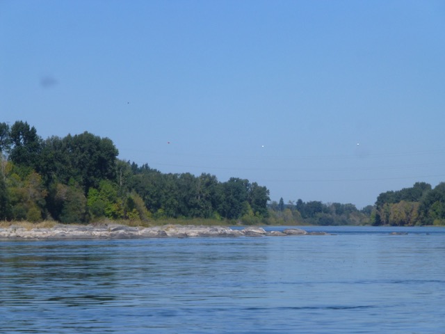
The launch at the river is a nice rock bar right above an old railroad bridge. I thought that the bridge was still in service, but then I saw a number of people walking or riding bikes across it, so it must be a rails to trails success story. Turns out this is the Union Street Rail Road bridge and it links together trail systems on either side of the river.
Our Kayak Portland Meetup is doing this excursion as a shuttle. So the first order of business is to get some of the vehicles prepositioned down at the take out at the Wheatland Ferry. Turns out there is a nice road on the West side of the river that runs pretty much straight from Wallace Park to the ferry landing. On the way out I noticed a number of signs advertising other river parks and boat ramps. We put our cars in the big gravel bed on the west side of the river and did the 15 minute commute back up to the boats. It was pretty fast and efficient.
We did this trip in early October. There has been no significant rain all Summer so the river is very low. The sun was out and the air and water temperatures were such that we didn’t need to bother with emersion safety gear. Won’t be very many more of those days this fall. Rain and cold must be coming as this is the Pacific Northwest no matter the awesome summer we just had.
 |
| Or maybe 74 |
We are starting at River Mile 84. One of the curious things about the Willamette river is the work that has been done to make it into a real trail. Or perhaps a long linear park. There are signs facing the water that announce many of the miles (big signs that say “84” for instance) and also many of the parks and such that are boat access friendly. There are “islands” and such along the river that don’t appear to belong to anyone and are available for camping during some parts of the year. During other parts of the year, they are underwater, which is probably why they appear to not belong to anyone. We passed one of these islands during our first half hour down the river. This time of year, the islands are pretty overgrown with small plants and brush. If you get out in the spring, just after the yearly flooding recedes, you will see all empty stretches of scored sand and stone. On the river trail maps, these islands are often listed as DSL islands. DSL is Department of State Lands. That makes sense to me.


We were seeing a lot of wildlife on this trip. We started off with water fowl. Mallard, Merganser, Heron, King Fisher, a Red Tail Hawk. A bit further down we saw a few deer and a curious little pack of wildly divergent goats. The goats must have been someone's pets (or livestock) but they were foraging down by the river bank. I called them divergent because they all looked so different from each other. A pack of mongrel goats.


The river has a very straight run for a couple of miles here and then runs into Keizer and hits the Keizer rapids. This time of year it is more like the “Keizer slightly less slow section” rather than rapids, but I get the feeling that when the river is up, this little S turn in the river is much more impressive. Even as it was, it was good to pay attention to the sea monsters and such and keep an eye on each other through the faster moving water. I am not too concerned about the fast moving water, but I am concerned with running into a much slower moving submerged tree branch should I accidentally go swimming. So, all in all, staying in the boat is a good idea.


Just before the rapids, however, on the west bend, is a little rock bar that one of our meet up members said was a great place to look for Agates. The sun was not perfect for this (a little behind some trees) but we spent half an hour looking through rocks there and I think everyone found at least one good size Agate (I found 2 plum sized ones).

After the rapids is a set of flat stone areas. I guess an old basalt flow now carved through by the river. More and More gravel beds also. We did not stop at the big gravel bed that is right below the rapids. This is part of the Keizer park and since there is ample access from easy parking, the beds are picked over by land based searchers early in the rock hunting season.


 |
| Beaver Slide |
As we get further out from the city the wildlife has changed. We are now seeing signs of beaver. What are beaver sign? Well, fallen trees is one big sign. Those guys take down pretty big trees. 5 to 10 inches in diameter. A couple of these trees were fallen over the water and the bases were clearly beaver chewed. Then there are also the slides. I have never seen such well defined, and apparently constructed, beaver slides before. I wish I had scored pictures of the best one, but I don’t think I did. It was around 30 feet long and it came straight down the bank into the water. It looked like a mud slough, about a foot wide with very well defined, almost rolled, edges. Perhaps it was built just by repeated use, but it looked like it may be have been pushed around and slapped into shape some. My understanding is that the beaver use the slides for emergency egress from the shore.
When we got down to Willamette Mission Park, just before our Wheatland ferry terminus, my partner and I left the company of the Meetup so we could spend some more time rock hunting. There was one big rock bed at River Mile 74 that is only exposed at low water. These sorts of places are nice to go to by boat since few other people get to stop there, but they are also a often covered with river scum and white mineral deposits (calcium?) which make it hard to find good rocks.


At Mission Park there are also more of the river facing road signs. One is a Mile Marker and another is a sign marking Mission park and stating that there is camping and picnicking. That later sign I only know about because I saw it from the shore once whilst exploring the park with my son. It must have been visible from the river at one time, and maybe it still is during the winter, but during the summer you can’t see it because of the undergrowth that has sprung up.


Here are some pictures of a good rock bar that is right across the river from Mission Park. My partner suggested I take a picture of the scum on the water at the landing because it wasn't just scum, it was thousands of pretty floating tiny flowers.


We searched for rocks some and then floated on down to our car on the bar by the Wheatland Ferry. While we were loading up the car, a motorcycle club came through and road the ferry. Sort of interesting to see 20 or 30 motorcycles driving onto the ferry at one time.
The ferry landing is another rock bar. This is where we had parked our car after the shuttle down and all we had to do was back it down to the water and load up our boats and head home. We should have taken the Ferry back across, it would have been the better way to go. Instead we drove out the river road on the West side of the Willamette picked up 99W and took that into town. But 99W backs up if someone sneezes so we would have been better off taking the ferry and going back out to I-5 north.
Here is how I would do a "smart shuttle" if I was doing this trip with people from Portland (or just my Partner). We would put the boats and gear in my car. Drive my car and her car to the ferry, cross the river and drop off her car. Then drive up the West side of the river to Wallace Marine park, unload, and paddle down the river. We get to her car, load it up and catch the ferry back and go to I5 and so home.
Wait..... did I just leave my car in Salem?
I hate it when I do that.


 |
| Beautiful flowered Pond Scum |
We searched for rocks some and then floated on down to our car on the bar by the Wheatland Ferry. While we were loading up the car, a motorcycle club came through and road the ferry. Sort of interesting to see 20 or 30 motorcycles driving onto the ferry at one time.
 |
| Motor Cycle Club on Ferry |
Here is how I would do a "smart shuttle" if I was doing this trip with people from Portland (or just my Partner). We would put the boats and gear in my car. Drive my car and her car to the ferry, cross the river and drop off her car. Then drive up the West side of the river to Wallace Marine park, unload, and paddle down the river. We get to her car, load it up and catch the ferry back and go to I5 and so home.
Wait..... did I just leave my car in Salem?
I hate it when I do that.