RMNP Day 2:
 |
| Moraine Park |
Day 2. Another Day to use our whiz bang 7 day parks pass !! It is $25 for one day but only $35 dollars for 7 days. I still have it upstairs, should I post a picture of it? It is so amazing.
Anyway, today we are going to do a hike. After slugging up that 200 yard trail to the 12,000 foot peak we are a little concerned about hiking at altitude with packs and such, but we have found a hike that sounds pleasant and the Ranger Volunteer told us was a good place away from all of the craziness at Bear Lake.
We never actually made it to Bear Lake. We headed out that way once but decided it was too far to drive. When you enter the park, however, there is an electric sign that lights up and says "Parking lot at Beaver Lake is Full. Use Shuttle." As far as we could tell (and we did enter the park pretty early some days) that sign is always on. But I digress.

Today we are going to hike Fern River up to Fern Lake. Doesn't that sound pleasant? We have our little day packs and have been told that we can probably find street parking down close to the trailhead in the morning. Our almost-a-ranger also told us that people come and go a lot down there so look around a couple of times for a parking space. So we drive over there. The road goes down alongside another meadow (park) like the one that we saw yesterday over by Fall River Road. As we now know, this is a moraine park and marks the bottom end of an ancient glacier. It is like this: The Glacier forms up in the mountains from falling slow. As the slow builds up it compresses. Once it gets to a certain thickness it changes its crystal lattice from the snow flake kind (that goes in all directions) to a new orientation that packed horizontally. This new lattice allows the packed ice to slide on itself. And so it slides down hill from the weight of the ice and gravity. As it slides it rubs against the rock and ground and picks up pieces of gravel and sand. Have you ever seen those pictures of Glaciers that terminate in the ocean? They calve giant icebergs into the water? Well glaciers that end on land also calve off big hunks, but these just melt and drop their dirt and sand deposits onto the bottom of the glacier. That is what a moraine is. So we are going to be hiking up a glacier cut valley. With a pretty little alpine river.


 |
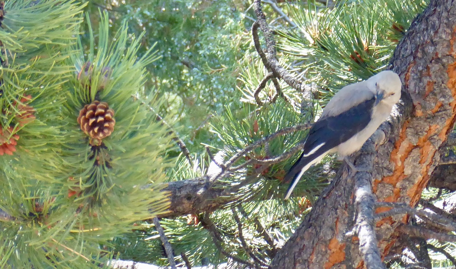
| Choke Cherry |
This hike starts out with a warning about Cougar. Don't hike alone. Don't go jogging. If you do jog, don't jog alone. (presumably you should always jog with a person that is smaller than you and looks more tasty). If you hike with Children, keep you children close. If you see a Cougar, don't run. Stand tall and make noise. Don't give them your children. If they attack, then abandon the children. Or fight. You can also fight. I had neglected to pack any children for this trip and my partner is much faster than me so I guess I will be fighting. I decided to carry a rock with me.
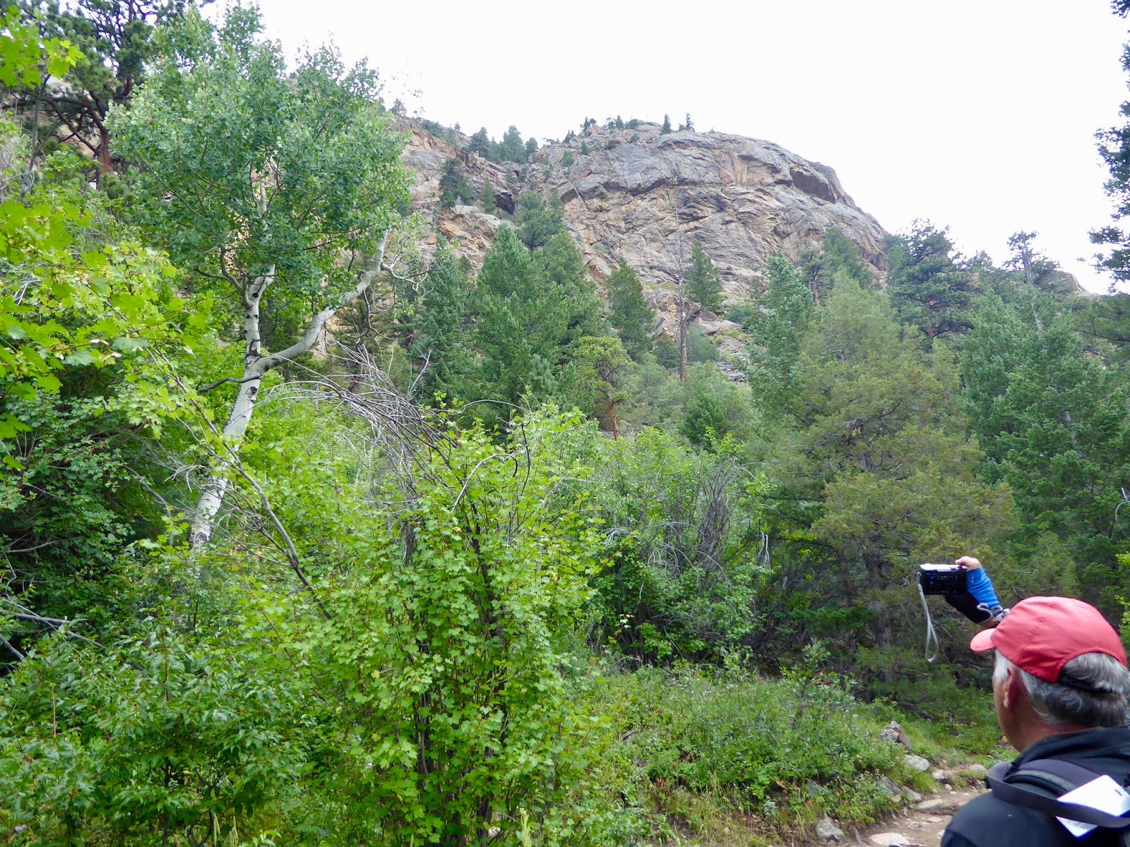
Fortunately, there are plenty of rocks around. The cliff facing to our right is very steep to and lots of big boulders have fallen down and decorate the landscape. The trail winds through them in places. It is pretty cool. There are also lots of places that you can access the river, either for trout fishing or just to sit and have a pleasant lunch.

The rock cliffs on our right are still soaring. We get a good view of them at times. There are also indications that this is a favorite spot for rock climbers and such. We saw one group of people carrying road and carbines and a large mattress. I thought that was a little strange until I saw their climbing setup. They were on a rock overhang that was about 3 feet off of the ground. They had the mattress set up and were practicing on this very low and safe rock (presumably before going to a location where the mattress would be less effective).
After a mile of this the trail ascends a cliff facing and then cuts over by a water cataract and pool. This is "The Pool". A nice rock formation with the river running through it. Fly fishing enthusiasts stand in the water make a long string go back and forth. You can see amused trout in the river watching and laughing amongst themselves.
 |
| The Pool. (shown with The Partner and The Cool) |
3 trails meet at this bridge. We are going to continue on up toward Fern River Falls, but we could also loop back around the other side of the valley by little bear lake and so to our car. There are a lot of people at this intersection (10 or 15). Lot of hikers. A couple of overnight campers (bigger packs) and the occasional joggers. The joggers are usually in pairs. Of course, if there is only one jogger you don't know if is just one jogger or if a cougar got the slow one.
 |
| Fairy Bells |
 |
| Mahoney (Oregon Grape) |
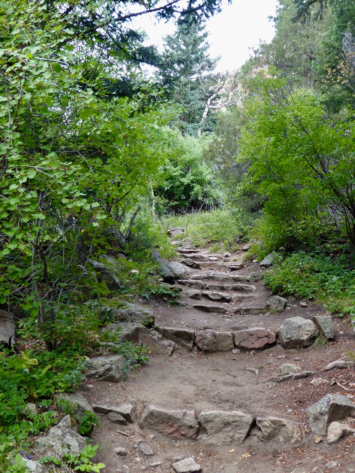
We start up toward Fern River Falls. The way is steeper and I am having a bit of a hard time with it. Hard to catch your breath. At times like this it is important to take a lot of pictures and point out key items of interest or unusually plants. I notice that the trail we are traveling on is unusually well maintained and shaped. To be more specific, there are a lot of large rocks (small boulders?) that have been moved around to shape the trail. I mean ALL of the trail. These rocks have been moved aside or found and placed and there are steps and nicely formed trail sections through out the length of the valley. Man, that must have been a lot of work. Ok. Enough sitting around. Well. I really should make a few comments about the flora. We are seeing a lot of plants that are familiar to us from Oregon. We see Oregon Grape (which in Colorado is called "Oregon Grape") and we see fairy bells and blackberries. The trees are mainly aspen and some sort of pine. The only mammals we are seeing is squirrels and chipmunks. I suspect that we are seeing either 2 kinds of chipmunk or perhaps some sort of stripped ground squirrel (Ok, the Trail Ridge Road Guide confirms that the smaller brighter striped one is a "least chipmunk" and the larger duller one is a golden-mantled ground squirrel. Keep that in mind). Neither is holding still long enough to take a picture. We don't see anything larger, presumably because they have been eaten by the Cougars.
 |
| Trail Rock Work |

 |
| Just seems like a lot of big rocks to move around... |
We hit a switchback and cross a creek and are now traveling up a very narrow ravine like valley with a creek on either side of us. One of them is going to become Fern River Falls in just a bit. Just a few more switchbacks and steep climbing. How far could it be? I am sure other people have hiked up this. Just maybe an hour more of slugging up this stupid fucking hill and.... wait.... was that Thunder? It was thunder. Well. That settles it, all of our mountain guide books warn us of the danger of being caught out in the mountain highlands during a thunder and lightening storm. Very dangerous. "Even more Dangerous than Cougar" our books say. Enough is enough, we turn back and head down hill. Everyone is doing it. Everyone except the family with 5 young crying children. "Get up that hill", says the dad. Perhaps he didn't read the poster about Cougar. Perhaps he was a Jerk.
 |
| That is a Bridge |
 |
| Ok, so no trail rocks here. Sue me. |
 |
| See the rain coat? |
 |
| Ahhh Lightning. Wait. Never mind. |
 |
| Note the dead trees. Pine Bark Beatles |
On the way back to the car we get some more good views of the big rocks going in the other direction. They really are quite beautiful. It does take 5 or 6 minutes for the 7 drops of rain from that thunderstorm to dry from our rain coats. Then we stopped for lunch at a nice little spot in the sun right on the bank of Fern River.
This is when I noticed some branches that sure looked like they had been chewed by Beaver. Hey Cool. This does seem to be prime beaver sort of area. And looking around we saw more and more beaver sign. Must be a lot of them in the park. I wonder if there is a place we can go see them?
We made our way back to the car and then drove to the nearby Park visiting center the Moraine Discovery Center. Important to go to these places to get good information and get your park passport stamped (see picture of stamps).
I asked the ranger there about beaver. She informed me that I may have seen beaver sign, there used to be beavers out there, but now there were no beavers in this valley. In fact, there were no beavers in the entire park. They had been killed by disease. Turns out we will hear more about this story....

In the afternoon we headed up the Trail Ridge Road back to the Alpine visitor center. This time we got there when it was open. My oh my, do they have big souvenir shop up there! Largest Souvenir shops above 11,000 feet in North America!! (In Nepal that have a little box of trinkets set out by the trail with a sign that says "Largest Souvenir shop in the world above 20,000 feet"). The store really is quite large with all number of different items for drinking and wearing that say "Rocky Mountain National Park" or perhaps just "Got Oxygen?". We get some shirts and mugs and then have a nice cup of coffee sitting out by this window that gives a fantastic view looking out over the valley that we drove through yesterday.
 |
| Panorama of the ancient Glacier Cirque |
 |
| souvenirs at 12K Feet. |
 |
| What is that I see out the shop window? |
 |
| Elk!! |
As we start back down the road, we stop at all of the big attractions that we had just driven by yesterday.
Though first we made a short diversion over to Milner pass to visit the content divide. On the way we espied a little black dot out on the meadow at Medicine Bow Curve (Tour Stop 9 in your guide). A guy next to us thought it was a black bear. It was VERY far away. He had binoculars and still thought it was a "Black Bear or maybe a log". My partner took a picture with her astonishingly good point and shoot camera. We think it was a Moose. What do you think?
 |
| See that black dot off on the left? |
 |
| Moose? Big Foot? |

Milner pass is a relative low point on the demarcation of the drainage line for the Continent. If you have good range, you can stand at this sign and have water that goes either into the Atlantic (via the Mississippi and the Gulf of Mexico) or the Pacific (via the Colorado River and the Gulf of California). There is also a nice little lake there (on the East side). The lakes and streams around here tend to have French or English trapper names. The pond is Poudre lake and the little river running out of it (beside which we saw that moose a ways down the hill) is Cache de Poudre river. Poudre was a French Canadian trapper. I am guessing he left his cache around there someplace. Oh, I am laughing at myself now. Wikipedia says that Cache de Poudre means "Hide the Powder". Some frenchmen hid their gunpowder on the banks further down in the main flatlands. So where did I read about Poudre the Trapper? On a sign? Make it up in my little head? And does this explain why blogger keeps trying to spell correct "Poudre" to "Powder"? More importantly, this river joins other water resources (that we will talk about tomorrow) and becomes one of the most important water sources to the farmers and cities down in the flatlands (like.... Denver).
 |
| Poudre Lake (drains to the Atlantic) |
 |
| A trail off down the Pacific Drainage |
 |
| To the Pacific |
 |
| To the Atlantic |
Ok, time to head home. Back past Alpine Visitor Center and on down the Trail Ridge Road. We still have some time to do some important stops
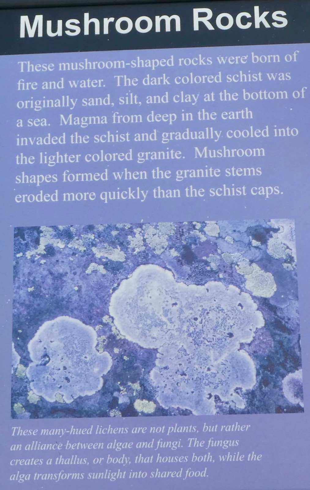
At 12,110 feet is "Rock Cut" (Tour Stop 6). This is a place where the road had to cut through the rock. I guess the place namers were off that day and so se have Rock Cut. Lot of parking here. Also a paved path leading through the Tundra and rock outcroppings. This is a very surreal area. Stay on the trail, the tundra is very fragile. It is similar to terrain and life that you might find above the arctic circle. I took some pictures of some nice little flowers. Growing from something like stone crop. We walked along and saw some standing stones called mushroom stones. The info sign informs us that these mountains are not of volcanic origin. They are all pushed up from the collision of two tectonic plates and this high mountain used to be deep ocean. At that time different layers of rock were put down and as they got pushed up above the water, different layers eroded at different rates creating the capped standing stones we see today.


 |
| The ground is covered with bits of the white rock (Quartz) that have eroded |
 |
| See, I don't just make this stuff up |
I have a question. How come it is that people with big expensive cameras don't have to follow the same rules as other people. I mean, if you have a large camera with long lens and tripod it is perfectly ok for you to walk right past the sign that says "Don't walk right past this sign" and go stand on the "Fragile Tundra Area" and take pictures. I wonder how large the lens needs to be before the Rangers and other authorities just stop and say "Oh, he has a camera".

On our way back to the car. We saw a Pika!! A Pika A Pika. These little mouse like animals, as we all know, live in various regions of North America. They go around the tundra gathering seeds and such during the very short summer. They can also shoot lightning our of their tails. A hundred yards down the walk I saw more movement, it was a Marmot! He mugged some for the camera. I really liked this particular stop and walk. If you get up to RMNP, make sure and stop at Rock Cut and wonder around and read the signs and see the rocks. It may take you a few passes to find a parking spot, but it is worth it.
 |
| Pika |
 |
| Marmot |
A little further along, beside the road out on the Tundra was a large heard of Elk. You could tell they were there because of all of the cars parked along the side of the road. You can only pull out and stop in designated spots, and when all of those are full, it usually means that you are close to something cool to see. We just drove slowly past.
The Trail Ridge Road calls itself the highest continuous highway in America. And it earns that name with some very steep sides and sheer cliff drop offs along the side of the road. Many of them in place where there are no guard rails. I kept my eyes on the road in such locations. I was amazed that there weren't stacks of cars off down the gully in some of these places. Surely not everyone is as good and brave a driver as me (and my partner).
At Forest Canyon lookout you get a good view of the canyon below us (forest canyon) and the mountains on the other side. Those mountains have the continental divide running down them. They are a bit higher than we are and don't have any established roads or trails. Down from the peaks, on the other side of the valley, we can see several "hanging lakes". These lakes are round and blue and are sitting right up in the mountain valleys. Snuggled up there in a little chain. I wonder how the areas where they formed got made? Did glaciers push up moraine that trapped the water? Land slides? Time to do some research.
 |
| A couple of Hanging Lakes. These are probably Inkwell (upper) and Arrowhead (lower) |
On the way out of the park we had a group of deer jump in front of us. So fun to see wildlife up close and not accidentally kill it. Luckily for the deer, my Partner was driving. Also lucky for them we had not pulled over to let the fast moving bumper huggers behind us go first.
Tonight we are going to eat dinner at the burger place. They are reputed to have the best fried pickles in town!!