Nehalem Bay State Park
View Larger Map
What a pleasant weekend getaway from
the city. Well, in this specific instance it was a long weekend
getaway from the suburbs, but it was still pleasant. This adventure
was in the middle of February and the weather was perhaps a little
more mild than one could usually expect. We didn't have much sun, but
we didn't have any ice either.
We did have a couple of kayaks tied
properly to the roof of a car, some sufficiently rain proof tents,
and a huge blue tarp (HBT, natch).
The state park is on a long spit of
land that extends out from the mount Neahkahnie headlands as a large
dune field between the Pacific and Nehalem Bay. I understand that in
the summer it is a pretty busy place, but on this particular
Presidents Day weekend, they only had half the drive ups open for
business and only about half of those were in use. Heck, we didn't
even have a reservation and we got a really nice spot right next to
the beach access point on Loop B.
 |
| Our Humble Campsite |
So this park, like many state parks, is
set up mainly for easy RV access. All traffic is in the clockwise
direction and you pull just past your spot and then back in at an
angle. I am sure this makes it easy to park one of those big RV's if
you have any backing abilities what so ever. I always struggled with
the damn things.
Anyway, if you just have a red truck
loaded with Kayaks and every single piece of vaguely camp-like gear
in the world, then access is simple. The park is divided into 2
sections, 3 loops each. The DEF loops were closed (and evidently have
a Horse Camping dedicated section) we were in the ABC loops. A-loop
is Yurts and reservation sites only. We were
on the ocean side of B loop. In the middle of each loop is a large
bathroom and shower complex. No Waiting !!
Since both times I have stayed here it
has rained on me, Chip and I knew that the first order of business
was to get our tents up. We did that, threw some gear in them to hold
them down and save our place and then said, “Hell, it is only 1:00,
lets go for a quick kayak !!”.
There is a boat ramp on the Bay side of
the park and use is free (with a state park pass or a campsite
payment coupon). We parked at the ramp, lugged our boats down the
rocks to the very sandy beach, and promptly got rained on, big time.


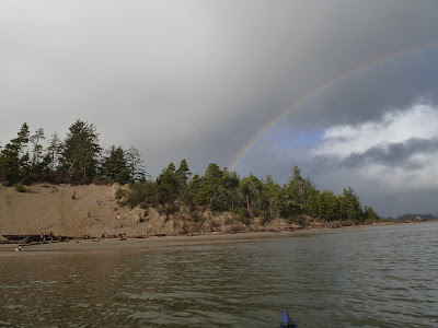
Well isn't this fun. But it passed over
us pretty quickly. We took a left and headed into the bay (away from
the weather). We were pretty lucky. The sun came out below the clouds
at the end of the day (as it often does in Oregon in the Spring and
Fall) and lit up one great multi-arch Rainbow. Chip said he counted 5
separate repeating color zones. I saw 2. He claimed it was his
polaroids that were bringing out the other dimmer bows. You can look
at the pictures.


We went about an hour into the bay with
the incoming tide and then remembered that we had a camp to set up
and a dinner to cook. And Crap, we forgot the aluminum foil !! No
baked potatoes tonight. Will have to settle for pork chops,
Coos-coos, and asparagus.
The other thing we did upon getting
back to camp was quickly set up the HBT, cause you just know that it
is going to be raining more. That turned out to be a good call.
Because it did rain off and on then entire weekend.
I had ordered this cheap 12V string of
waterproof LED lights. We strung them up to the tarp and powered them
with my big utility battery and Poof !! We had a campsite that didn't
quite look like a homeless encampment.
And why do I say this? Because I was a
little self conscious. I mean, all around us were this large,
diverse, and expensive RV's. No 2 even vaguely alike. My favorite was
the short silver Airstream (shinny) being pulled by a BMV SUV, but
there were LOTS of nice ones around. Is it funny that people would
pay so much to get out into nature? We got a lot of suspicious looks
from the rich folks walking their dogs out to crap on the beach. But
they relaxed once they saw our Kayaks.
That was the one thing sort of bad
about having the site right next to the beach access. On the one
hand, we had more room than other sites, on the other hand, everyone
in the camp had to walk past us at all hours to get to the beach. And
it was cold. So no Bikinis.
Can I rant again about dog owners that
bring the little bags to put their animals offerings in and then
leave said bags by the sign that says “pick up after your dog”?
Do we shoot the dog, or the owner? Sorry, I know that camping dog
owners live to walk, skip, and sit in dog shit, but I just prefer not
to.
It always rains at night on the beach.
Just saying. Make sure you have an adequate tent and drainage. Oh,
and a good supply of beer is also helpful.
During the night there was a commotion.
Hard to come alert in the cold and dark. Hard to concentrate. But
even through the haze, I know there is a coon out there. Dangit. What
did I leave out? I pull on some shoes and bring my head light and
exit the tent. And there were two glowing embers in the darkness.
They stare. They don't run. They don't waiver. Is that teeth? Could
this be some monster? A wolf perhaps? No, it is a raccoon. A really
well fed HUGE raccoon. And not at all intimidated by some guy in long
underwear and untied shoes. But he finally shuffles away, not wanting
to be infected by some perhaps rabid human.
God. Back to bed.
Did you know that an standard extremely
comfy aero bed twin mattress has a thermal rating of like .5? This
means it is just about the same thermal insulation as a trash bag.
Keep that in mind when car camping in the cold.
The next morning I got up and got the
coffee going and checked the tides. Low tide around 11:30. Ok, we
should be done with breakfast by then. We can ride the tide up the
river to Wheeler or beyond and then perhaps fight our way back into
the bay. We don't have enough time to wait for the tide to change, I
am not getting back to camp at 8:00.


So, some history on the bay.
This entire area was prime and huge
forest back in the late 1800s. But there was no good way to get the
trees to market, so the woods stayed relatively safe and the areas
stayed undeveloped. Until the railroad came through. The rail came
through the Tillamook mountains along the Salmonberry (see my summer
hike adventure) and then followed the Nehalem river down to this very
bay. Here the town of Wheeler grew up.

 |
| Not what you think. Some clam pushed this mud tube up. They were all over. |

From the boat ramp on our state beach
sandbar, we can see the entrance of the river to the ocean to our
right, and the little town of Wheeler nestled in the sadly clean cut
hills to our left. The wind and the tide are blowing us up stream, so
we head that way. It is sort of a strange ride. Sometimes it gets
rather lumpy from the wind at our backs, but we also have this
problem of running out of water in the middle of the bay. A few times
we have to back track and head around the shallows. What it is
looking like is that the bay is this huge sand deposit, big and flat
and only a few inches below the surface of the water at mid-tide. I
had wanted to sort of do our trip from last fall in reverse and go up
the very protected side channel, but it is becoming clear that there
is no side channel. There is just mud and sand. Ok, perhaps after
lunch. So we drift up toward Wheeler and then do a left up the side
channel across the way from town. We can see the highway and the 100
year old railroad that runs up the coast, using trestles to jump the
creeks every little bit.


We are surrounded by these Mud islands
that have banks that around around 4-5 foot tall with grass growing
on the top. Perhaps an occasional stand of trees.
The little side creek is pretty
shallow. Maybe 8 inches down the center. And lots of water logged
sticks on the bottom. I mean LOTs. In some places the entire bottom
is water logged sticks. Chip thinks this part was once called “Alder
Creek” because of all of the alder growing here, but that was all
cut down and these sticks are all that is left. Sounds like a ghost
story.
After a couple of tries, we find a sand
bank (as opposed to a mud bank) where we pullup and get out to eat
our lunch. This gives us a chance to get up on top of the these mud
bank islands and see what is up there. Just Grass.
The Tide is coming in fast now. Even as
we watch, our foot prints from our landing are filling up with water
and disappearing. I take this as a good sign, because I want to go
down the North side channel that is only there with the tide is up.
We are eating lunch at the River entrance to this channel. The other
side empties into the bay more toward the ocean. The current is
moving up the channel from where we are eating lunch. Wow, that means
this is a tidal creek, with the water moving inward from both sides.
We can tell when we are at the midpoint because there won't be any
current!
After lunch we head up the creek. Chip
pulled out his Iphone and did a historical tide calculation. He says
that in 45 minutes the water will be about as high as it was the last
time we went through. It was touch and go then, but we made it.
I think his calculations were 30
minutes off.
We paddled up the channel a few hundred
yards and then got blocked by sticks in the mud and low water. But
the tide was coming in fast. We could actually watch as stick we had
selected as a reference point submerged under water. We are talking
about the water level going up a few inches in a few minutes. A Kayak
only needs like 3 inches of water, so when we ran aground, we could
just sit there and chat for a bit and then rock and paddle and inch
our way forward. It wasn't very fast, it wasn't very dangerous, but
it was sort of interesting, in a “gee never did this before” sort
of way.


 |
| Stick Monster. Staring at me. |


We finally came to the part where the
current was coming in from both directions and then we just started
paddling. The Sun was getting low in front of us, and and the bay was
opening up all around us (as the mud banks disappeared) and we
powered our way back to the landing.
The last time we did this trip we saw a
bunch of eagles, some Kingfisher, and the usual round of ducks,
cormorants, and Heron. This time, not so much. Sort of disappointing
in the way of wild life in general.
That night we pulled out the cameras
and went out to the beach to take star pictures and have fun with
lights. If you don't have a good astronomical laser, you really
should get one. They are good for killing the zombies that walk the
beach during a full moon.


All in all, a great adventure. Lots to
see. Must try to reserve a slot for camping out there sometime during
the summer.
No comments:
Post a Comment