Bull Island in the Cape Romain National Wildlife Refuge, SC
Back in the 1600’s, the new King of England needed a way to thank his key supporters that had just help him to retake the throne. He did this by giving them land grants in the New World. But they were sort of crafty grants, they didn’t out and out give them the land to sell, but rather they gave them what amounted to tax rights on goods generated on those lands. And they were very specific rights. A certain percentage of the profits from Indigo, Rice, etc. So if these guys wanted to make it rich, they had to create and foster settlements and plantations in the Carolinas.
3 ships set out, all aiming for a place a bit south of where they ended up. But they made land fall, and found a nice little place to build a fort and start some deer skin trade with the local Seewee people. The barrier island they were on was called “Island of Birds” in the local language. The English stayed there for a while but eventually were convinced by the Seewee to try a place they knew that was up a river not far south of their current camp. This new place was called Charlestown Landing and eventually (with just one more small move) became Charleston. On a side note, the reason the Seewee were so friendly was evidently because they had found out that the Spanish were working their way up from the South. The Spanish had a bad reputation as being only interested in conquest, not trade or cohabitation. So the Seewee were probably trying to use the English as a protection from the Spanish.
Some of the English stayed on The Island of Birds, however, and continued to trade and to map the area. One of the map makers was Mr. Bull, and the island started to be referred to as Bull’s Project or Bull’s Island.
That island, and the area around it, was name a national park in 1933. It is backed up on land by a huge national forest. The area hasn’t been fished or hunted in a long time and some of the area is considered class 1 wilderness by the US Government.
And that is where we are going hiking today: Bull Island.
We road over to the island on a little pontoon ferry with 20 other folks. The little history lesson above and most of the nature facts below were told to us by the ferry captain and nature guide (who's name, I think, was Will).
 |
| Table of stuff found on Bull Island (on the Ferry Ride) |
 |
| A Handsome Couple on the Ferry |
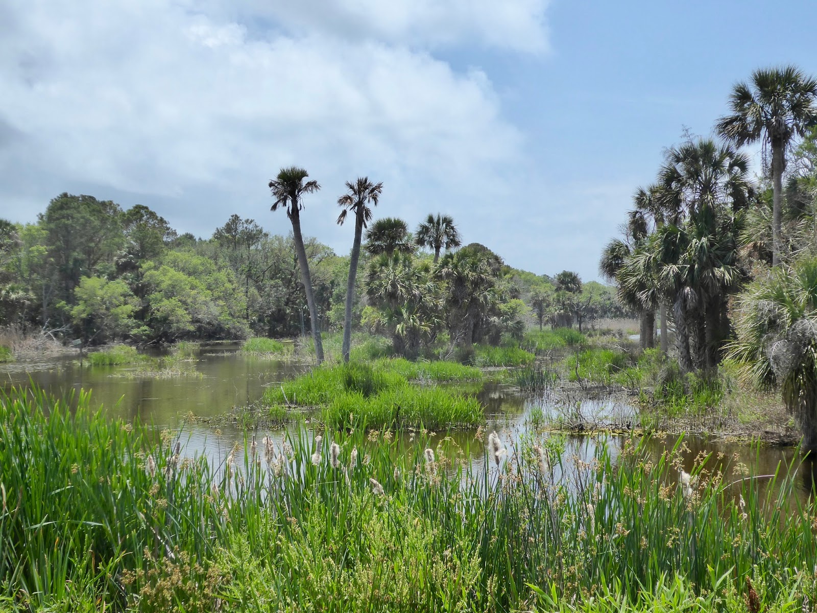
We had a pleasant 30 minute ferry ride out to the island. As I mentioned, Bull Island is a Barrier island. This is an island formed by wave action that deposits sand. The sand builds up, eventually grass and such start to grow. You build up top soil, you get more substantial oak and pine trees growing, and now you have a long skinny island.
The straight distance from the ferry pier at Garris Landing to the Bull island dock is not that far, but the actual path involves weaving through the tidal marsh and picking out the deep water channel. On our outward trip, the tide was very high, the marsh grass roots were all awash and the oyster beds were deep underwater. Our Captain pointed out across this wide bay and told us that it might look safe to cross, but at low tide all of that was either oyster beds or mud flats.

I lived in the low land Carolinas when I was a teenager. I worked on the waterfront at a boy scout camp for a number of summers and have certainly spent my time in the marsh. But I guess I never really looked or thought about what the Marsh is actually made up of. Here is the deal, the marsh is a large mud planter bed in which grows one kind of plant, the marsh grass. Try this out. Try to think of a place you have been where, over hundreds of acres of rich fields, there is only one species of plant growing. Everywhere you look, miles of this one plant. Nothing else competes for that space or those resources. The mono-culture is everywhere and all of the other animal species that are there are ultimately dependent on that plant for their food source. Why is there only the one plant? Evidently because it is the only grass that has evolved to live in salty water. In fact, it has the ability to squeeze the salt out of the salt water and excrete it through its leaves. Ok, it isn’t actually salt water, it is brackish water. The marsh only grows where there is an inflow of fresh water to create the brackish water marsh. The marsh grass converts sun and salt water into plant. The plant dies and the local bacteria breaks down the matter into the super organic mud that is the bed for the marsh. The mud is a fine grain mud called Pluff mud. I always thought it was called that because that is the sound a rock would make if you threw it it as it sank out of sight. This mud is sticky and smelly and often very deep. It looks like it might be solid, but if you step in it, you might just sink up to your thighs in the stuff. And it also hides razor sharp pieces of oyster shell, so stepping into it isn’t something you want to do. The plantation owners and farmers back in the 1600’s and 1700’s knew that the mud was rich in nutrients and they would go out and dig up the mud and plow it into their fields. In fact, that is really where the name of the mud came from. Plow Mud. Except in those times plow was spelled Plough, which got mispronounced into Pluff (like enough). (At least, that is what Captain Will told us).
 |
| The Marsh Goes on for ever. |
The oysters grow on any hard thing that sicks up out of the mud. Usually an errant sand bank or other oysters. The oysters are filter feeders. They eat the bacteria growing in the mud and other yummy things floating around. They filter the water in the estuary and keep the marsh clean. I mean, muddy but clean. If you pull out a chunk of oysters, you will find a bunch of oysters that are all glued to each other. Many times a large one with many smaller ones glued around it. The large one is the female, and the smaller ones are her boy friends. The males want to be close to the females as oysters do broadcast fertilization. When the female dies, the oldest largest male in the cluster will turn into a female. In fact, all oysters start life as a male.
After our boat ride out, we docked at where a little tidal creek comes close to the land and were told we had a 1.5 mile walk out to the beach.
After our boat ride out, we docked at where a little tidal creek comes close to the land and were told we had a 1.5 mile walk out to the beach.

Bulls Island has a number of roads on it. But be careful about trusting the maps that are available. I think a lot of the old roads are not maintained and may have grown over. For instance, I saw no evidence that Mills Road ran very far from Beach road, even though the map advertised that it ran south all the way to the end of the island.
Our captain had recommended that we spend our time (3 hours) either by walking directly to the beach and then going beach combing (a popular option) or taking the “Turkey Walk Trail” around the fresh water ponds on the island. This was the most likely way to see Alligators. My partner had listed “seeing Alligators” as one of her trip goals, so we went that way. Our guide had also told us to be wary of Mosquitos on this trail. Consider yourself “Foreshadowed”.
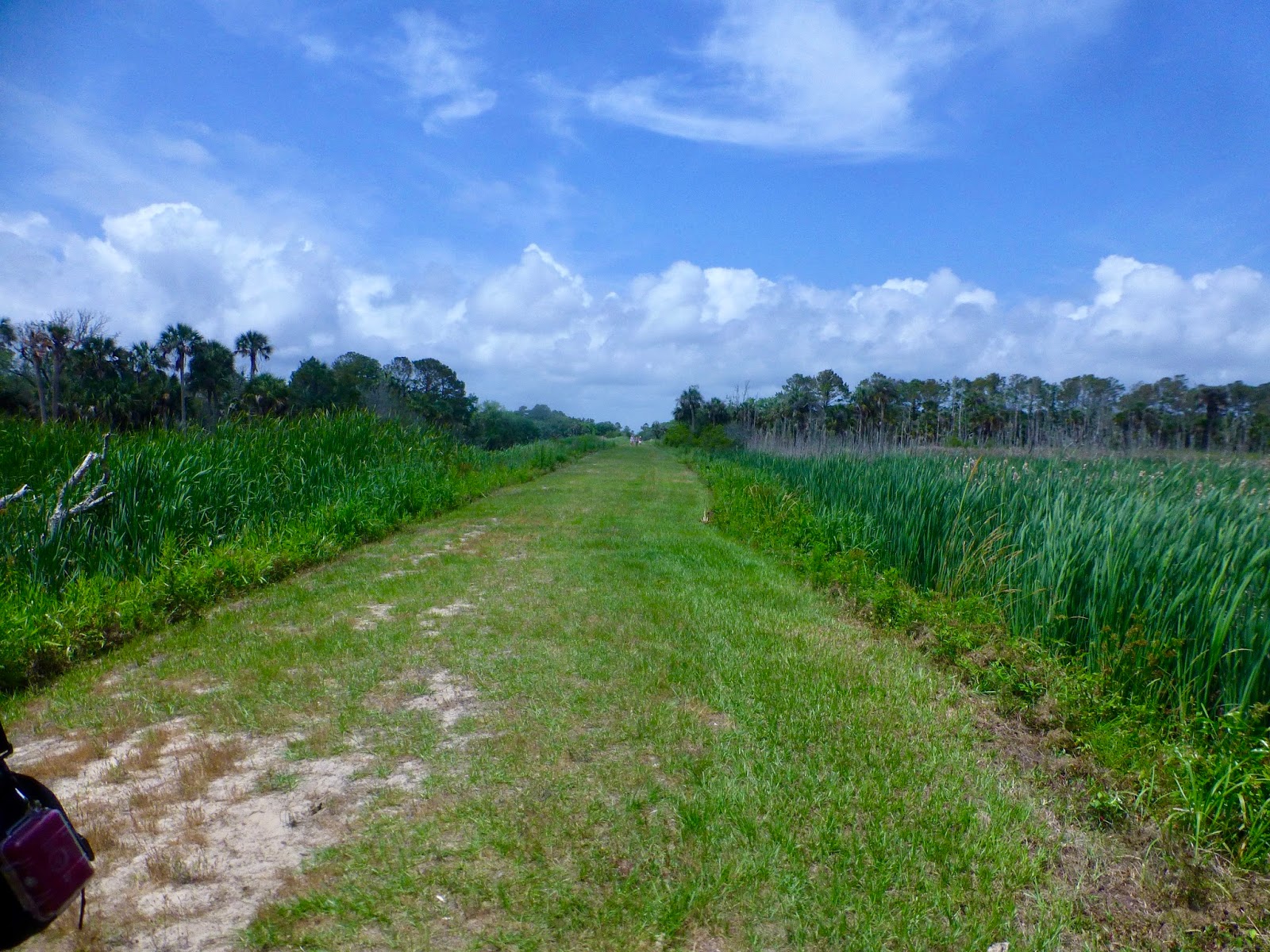 |
| One of the Dike/Roads that go through Island |
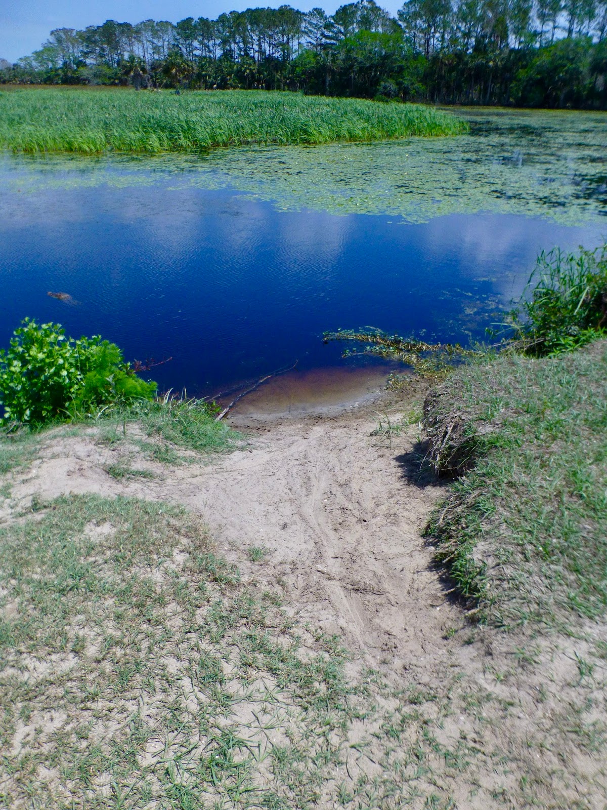
We set out down the trail (which starts as the Spring House road) and then turns left to run parallel to Beach road out through the set of fresh(er) water ponds. The two roads that run from the estuary toward the beach are actually dikes. They are 20 feet wide and about 3 feet above the water level in the ponds. There is a water flow control mechanism that is in the middle of the dikes. I think this allows water to only flow out of the fresh water areas when they are full, but I am not sure about that. I came to Bull Island once in High school. I think it was part of a trip I did with my Explorer troop that was sponsored by the local Wildlife research center on James Island. My memory is that we were taken out on a government boat and given a tour by a uniformed woman. But… that was 40 years ago. My memory is that the fresh water ponds were then used as fields for growing rice. You had to be able to flood the fields, and thus the dikes and water control. When walking across the dikes, we wanted to see Alligators. And there one was, 100 yards ahead lifting himself up and walking across the dike into the water. Oh My. 5 or 6 foot. A real live Alligator right there in the sunlight.
aa


 |
| This guy is swimming |
As we approached the place where the gator had slid into the water we noticed that there were several other heads milling about. 1,2 3,…. at least 5 gators floating around and eyeing us rather suspiciously. We got close enough that we could see their bodies under that water and much to my surprise I see that, when motionless, the gator eyes and nose are above water, but the body is hanging up and down in the water. I had always thought that the body would be splayed out behind them, but that only happens when they are swimming, which they do by swishing their long tail back and forth.
 |
| Fresh Water on the Left. Salt Water on the Right. Funny Hat in the middle. |
This is when I realized that on one side of the dike-road the water contained water-lilies and cattails. The other side had marsh grass. Therefore one side was a fresh water pond and the other side was brackish water marsh. Now, this is a barrier island several miles off shore and surrounded by either brackish marsh or salt-water ocean. Where did the fresh water in the pond come from? Is it all rainwater? or is there some sort of fresh water springs in the area. That is possible, I know there are artisan springs in Charleston.

|
| This looks like something out of Jurassic Park. I need a pterodactyl |
After the dike-road crossed the pond, it entered an oak and palmetto forest and angled left back toward the ocean road. This was all well and good except that we were immediately set upon by a pack of ravenous mosquitos. These babies were aggressive and out for blood!. Me and my partner's blood, to be precise. We had squirted down with some Jungle formula OFF but the little buggers were still coming in to at least check us out. We were walking fast as to try and create a little of our own breeze and get through the swarms, but this meant they were hitting me in the face and mouth. Ugghhh. My partner said I had a huge swarm behind me; landing on my back and head. I got a few bites right through my sun shirt and cotton undershirt. Wow.

We finally came out back on Bcean Road and hiked the rest of the way out to the beach. South Carolina beaches are long, sandy, and very flat. The difference in the width of the beach between high and low ties can easily be 100 yards. And this beach was empty. I mean, there were 20 people on it, but they were spread out over a few miles, so…. empty.

 |
| Now that is a big empty beach |
This beach has a reputation for being a great place to go beach combing. You are allowed to take a small bag (a grocery store plastic bag) full of shells back with you. You can take anything that was once alive but is now dead. So, shells and such are OK, but no artifacts. No bricks or pieces of pottery. Down at the North end of the beach is a place called Bone Yard beach. It is an area that used to be woods, but current sand flow patterns have cause it to be in the surf. We didn’t get there, but it is supposed to be a great place to visit. Our boat captain said that if a person wanted to go to Bone Yard, they had to either hustle, or come back another day on the morning Ferry (we rode the afternoon ferry out, which returns promptly at 4:00).
As it was, we didn’t get to the beach until around 2:30. So only a half hour before we had to be headed back toward the landing. We pick out a nice spot on the beach and sat and ate our lunch. The sun was hot, but the breeze was cool. We spent a few minutes walking in ankle deep atlantic ocean. The beaches here are so gradual that we probably could have walked out 50 yards in the ocean and still stood up, but ankle deep was good enough for today. Then time for the return. We still had that 1.5 miles back to the boat landing. Turns out you can do 1.5 miles on flat grass a lot faster than 1.5 miles on steep Oregon Mountains. Who Knew?
We stopped at 3:30 at a little park area next to the house that is on the island. This parks has a number of picnic benches, a set of bathrooms, and a storm shelter. The storm shelter is covered with walls and doors. It has benches for like 30 people and a pot belly stove. I guess it might snow in the winter, or a winter storm could trap some people out there.
Back to the boat, which left promptly at 4:00. We actually left just little before 4:00, they must have been counting heads.
On the way back we saw a few dolphin.
Did you know that the dolphin you see in the estuaries along the Carolina coast live their entire lives in the estuaries? They are actually a different subspecies than their larger cousins that live in the oceans. They might meet each other and interact with each other at the mouths of the rivers, but the estuary guys stay in the little tidal creeks and the ocean variety stay in the ocean. Estuary Atlantic Bootle nose dolphins usually get to 400 pounds. The ocean guys get up to 1000.
The dolphins have to learn all of their complex behaviors. This mainly means they learn how to hunt. They have several techniques they use to cooperatively hunt fish. There is one method, however, that has only recently been discovered. This method is called strand fishing. The dolphin work together to drive the fish such that they strand themselves on the beach. Then the dolphins come sliding up on the sand, always on their right sides, and catch the stranded fish with the sides of their mouths. Dolphins that feed this way have developed calluses and such on the right side of the bodies and heads. This behavior used to only be seen around Bull Island, but in the last few years it has spread a few hundred miles north and south. The speculation is that the idea on how to hunt this way is being spread by the ocean dolphins somehow communicating it (by doing it?) to other estuary dolphin groups.
Want one last fun fact before we get back to shore?
The loggerhead turtle also nests on Bull Island. They come up on the beach and make nests during the right season. Well, the local wildlife groups have been protecting and counting the nests for the last 30 years. A strange thing happened the last two years. The number of active nests has been around 1000 since they started keeping records (30 years ago) but in the last two years the number has jumped to 2000 active nests. What is going on? Well, what they think is this: The time it takes a loggerhead female to reach sexual maturity is around 30 years. And the females come back to the same beach from whence they left. So the females that the conservationists starting saving 30 years ago are now returning to lay eggs. The project is working. Perhaps Signifcantly.
And with that, it is time for the captain to stop telling stories and to dock our Ferry. We are home.
Wasn’t that fun?

Thank you for sharing your experience! My wife and I are planning to visit Bull Island in March, and I’m soaking up all the stories and information that I can! ~Ian Alexander
ReplyDeleteThanks for leaving a comment. Don't forget to take those mosquitos seriously :)
Delete