Perfect Coast Weekend: Part I: Saddle Mountain
We are having one hell of a dry October
here in the Pacific Northwest. That isn't great for the snow pack but
it makes for truly grand sunny weekends, which are very rare this
time of year. Especially at the beach. My partner had arranged for us
to have a 3 day adventure to the coast just west of Portland and I
had this idea that since the weather was so nice and since we
couldn't check in to our B&B until like 3:00..... why not climb
Saddle Mountain?
View Saddle Mountain Trail in a larger map
See, Saddle Mountain is almost all of
the way to the coast anyway, so it takes quite a bit of time and
effort to get out there to climb the thing. And even when you get out
there, most of the time the fog boiling up from the nearby ocean
comes over the hills and obscures the view. So I was thinking, we are
going to drive right by it anyway and the day is so clear and
warm....
 |
| We are going up there !! |
You get to Saddle by following route 26
from Portland toward the ocean and then when you are about 12 miles
from the end of the road, you take a sharp right hand turn into the
Saddle Mountain Natural Area. Then drive 7 miles down a narrow windy
road and you end up right at the foot of the mountain in a nice
parking lot (with bathrooms !!). On a nice day like today you can
see the mountain looming overhead.... 2.5 miles of trail and 1600
vertical feet right up there.
We brought our hiking gear and I was
careful to bail on a lot of the usual emergency stuff I carry. Like
the shelter. But I have one major rule that I now always use when
hiking the mountains around the Northwest. No matter how nice the
weather is, always carry an extra fleece. You just never know. Oh,
and I have the first aid kit and water and water purification tablets
and compass and knife and all that. But it is the extra fleece on a
warm day that I am most conscious of appreciating when the weather
suddenly turns on me and I am 4 miles from the car and freezing my
butt off.

I usually come to Saddle Mountain to
enjoy the wild flowers. Some very unique species grow here on the
alpine meadow slopes. But this is just the wrong season for that.
This is the season for views. And for rocks. Why rocks? Well,
because there aren't any flowers and we have to look at SOMETHING.
Saddle Mountain was created long ago
when it was the ancient ocean end of a lava stream. The molten basalt
dumped into the ocean and create a huge pile of fragments that heaped
together in a sort of basalt and clay mashup and, when the ocean
receded, became Saddle Mountain. This is such a unique feature that
everyone that has come by has commented on it. The local Clatsop
tribe, for instance, called the mountain Swallalahoost, which
translates as “Swalla shaped like a young Girls Hoost”. It
figured heavily in their creation legends. Lewis and Clark commented
on the thing from their winter camp over by modern day Astoria. They
called it, “roged and uneavin”. One of the things I like about
Lewis and Clark is that they were not constrained by today's strange
ideas of uniform spelling. The mountain finally got its modern name
in 1841 when Navy Lt. Charles Wilkes named it. You want more fun?
Wilkes is the same guy that “Wilkes Land” is named for in
Antartica. He was the first person to see Antartica. Well, at least to put
his observations on a map. He was one of the officers on the little
known sequel to Lewis and Clark when the navy put a few ships
together to plot the Pacific. They did some cool things and returned
with a huge collection of animals and tress and such which became the
foundation for the Smithsonian collection. You don't hear about them
much because the officers had a falling out with their commander
(i.e. Wilkes) and caused such a brouhaha that, instead of making them
heroes like L&C, the government just swept the entire thing under
the rug.
Where was I?
Oh yes. Rocks.
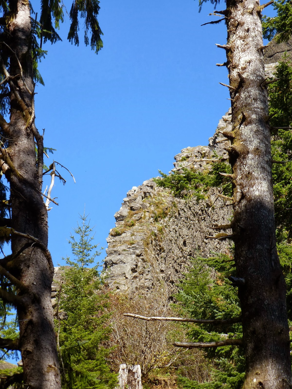
There is this one feature that my
partner and I were specifically intrigued with. It is a vertical wall
of rock. Really a wall. Like 3 feet thick and flat on both sides just
like some natural forming castle wall. How did it get like that? How
does molten basalt form into such a cool shape? Was it flat at one
time and then got stood up on a side? Look at the pictures. Ok, now I
need to go do some research..... [time passes]. All I found out was
that there are lot of people that will sell you basalt rocks to make
walls for your castle. The internet occasionally sucks.


As I mentioned before, 2.5 mils and
1600 vertical feet. So up up up we go. My partner has already warned
me that I had better not use the phrase “Just around the next bend”
but I am armed with more witty reparte than that. Why? Cause I have
hiked this trail many times and I am heavily armed with the truth.
Which is: Ok, the really hard part is coming up, but the view is EVEN
BETTER than here. That is how the trail is. Hike a hard part, get a
good view. Hike a harder part, get a better view. Hike the Fraking
hardest part, get one of the best views you can get.


Right at the 1.5 mile mark you leave
the trees and are now on open rock and alpine meadow. You can
see way up to where you are going. In the spring and summer there
will be iris and tiger lily everywhere. Then you enter some trees.
At the 2 mile mark you come to the last of the cleverly placed picnic
benches. These are wild benches that only grow on Oregon mountains.
This last bench is where you rest up. Eat a power bar. Drink some
water. If the weather is bad, put on your rain coat. Cause when you
leave the tress, in 100 yards, you are on the unprotected ridge of
the mountain. The roadway is slippery, the cliff face is just right
there, and the danger is greatly enhanced by the fact that you will
be starring off at the fantastic view.


 |
| Stone Crop |
Ahead of us is Neahkanie Mountain. A
little to the left of that we can see Nehalem Bay. Once we get a
little further ahead and see around the corner we see Seaside. I turn
to my partner, “Remember when we were at Gearhart Beach and I said, 'Hey there is Saddle Mountain, we
have to hike that sometime' ?” And she says, “Yes, and you
really shouldn't use double sets of quotes”. “Oh,” I say,
somewhat confused. We pass through a little corridor of brush and
start our decent into the saddle. We see this:

Have I discussed the trail at all
at-all? That is, how it is constructed? It is a rather unique trail
construction which consists of large broken chunks of stone held in
place with chicken wire that is nailed into the native rock with re-barb
pegs. It has such unique footing features that it has oft made me
think that if I had a team of extremely gifted engineers, several
months of design time, and lots of money for research and
development, I might just be able to come up with something less
desirable to hike on. But I doubt it. It is extremely slippery when
wet, grabs your boots or hiking poles when you walk on it, and is
built up high so you have to step carefully down off of it when ever
you come to a termination. To really rub it in, some of the sections
of trail have the old boardwalk and stair well trail still in
existence (if somewhat broken up) to show you what a real and
comfortable trail would look like if someone should care to build and
maintain it. So, hike slow. Plenty of good places to slip and break a
leg, no reason to hurry and find them.

Today we scurry up the last steep
part pretty quickly. Half-way up that second part of the saddle I
lift my head and there on the horizon I can see Mt. Saint Helens
and Mt. Adams. Such pretty snow capped peaks. A few more steps, and
there even larger to the left of them is Mt. Ranier. Wow, that puppy
is way off in Washington State !! But where is Mt. Hood? It must
still be behind the part of the sadle that we first traversed. Got to
climb another 50 feet before we can see it. From this point it is
clear that we are actually a little closer to Ranier that we are to
Hood. When we get up to the summit, we have a pretty glorious view. We
see 5 snow capped volcanoes (Jefferson was just visible off to the
South East), a great view of The Columbia River, including the
Columbia bar and Astoria. We can see Seaside and the beaches there
and all the way south to the Nehalem River where it dumps into the Pacific.
All in all a glorious sunny view. The summit of Saddle Mountain is a
basketball court size piece of rock surrounded by a metal pole fence.
There is a little table/bench thing on the north side. On the south
side is a memorial marking the place where someone went beyond the
fence in the fog. Don't do that.


One of the things you learn about if
you day hike up mountain trails in the winter is to keep track of the
time. It get's dark earlier every week and you really need to save
time to be off of the trail by dark. Today we have an even more strict
schedule. We need to be in Arch Cape at our B&B by six or we
will miss check in. So, it's getting to be around 3:30, it's
going to take us 2 hours to get off of the mountain and at least an
hour to get from the parking lot out to the road and then down to the
hotel. Oops. We had better get going. That trail is hard going down,
too. One of our friends commented that the saddle mountain trail is
up in both directions. That isn't really true. It doesn't wind you
going down, but you still have to go slow and be careful on the dang
chickenwire. As it is, we make it to our B&B with 5 minutes to
spare. So ending a wonderful sunny first day of what is about to
turn into a wonderful sunny weekend.


No comments:
Post a Comment