Kayak Portland is a Meet-up. OOPS is a
club. But what is the difference really? When Billy and Jimmy and
Barbara and I used to meet in the treehouse and not let Bruce in,
wasn't that a club? The OOPS people say no. What do they know? Isn't
Kayak Portland a club?
No, says my Kayak Portland Friend,
Richard. “The OOPS guys have some legal obligations that we don't
have in a Meetup.”
“And how can that be?” I ask,
“Wherein doth the difference lie?”
“Well,” says he, “They charge
dues”.
Ah. And it is clear. And he is right
(dammit). By charging dues they are incurring some amount of assumed
or stated responsibility. They took my money so they “owe” me
some service. Unless they have good lawyers that make me sign a
waiver.
But Kayak Portland has no dues. No
rules. No (legal) social obligations. We are not a club, we are just
a bunch of people that happen to show up at the same place at the same
time and have some fun.
View Warrior Rock Lighthouse in a larger map
Today 50 Kayak Portland Meet-up members
all randomly and mysteriously decided to show up at Scappoose Bay
Boat Ramp at 2:00 on a hot sunny Sunday with our myriad of Kayaks and
take our colorful flotilla to the Lighthouse on Sauvie Island.
My partner had knee surgery last
wednesday (God, don't let her doctor read this) and we were taking it
easy, but she couldn't get her knee wet. So she had to where her skirt
(kayak skirt, Doc) to make sure her leg would stay dry. I wore mine
too to be supportive. (And because I knew she would flip me over if I
didn't. And if someone is going to flip you over, you should really
be wearing your skirt). The nice thing about being tucked in like
that is when ever you get hot you can just maneuver to someone's bow
and use that for a bow assist to flip over and cool yourself off
(make sure you are in sufficiently deep water first, you don't want
to dip yourself into a tree stump or a muddy bottom).
 |
| OH..... In the Boat !! |
 |
| Time to get Cool |
The water is pretty low on the lower Columbia at this time of year. Julie, the trip leader, told me that
the dam control guys (damn control guys) had turned off a lot of the
flow on the river for a couple of days (“Sort of like rolling power
black-outs, only with water”, she said) and so the level of water
on the columbia was down about 2 feet. My Partner and I didn't think
it was very much different than when we had been out a few weeks ago,
but I wasn't sure what the tide conditions were this time out so it
was a little hard to tell what was really going on. I know that once
we were out on the Columbia there was very little current.
It takes a powerful long time to get 50
kayaks out on a little boat dock, put in the water, people in them,
and then heading out. I would say “herding cats” but it is more
the opposite. If anyone starts going someplace, EVERYONE goes to
follow them. So you can't sneak off for a quick explore without 20
people assuming you know where you are going and following you. Be
careful. With great power comes great responsibility.
 |
| Guiness Book of world records 3-Bow Flip !! |
We milled a bit. Then Julie called us
all together, pulled out her new bull-horn, and told us the plan and
got us moving. It could not have been a better day for it. There was
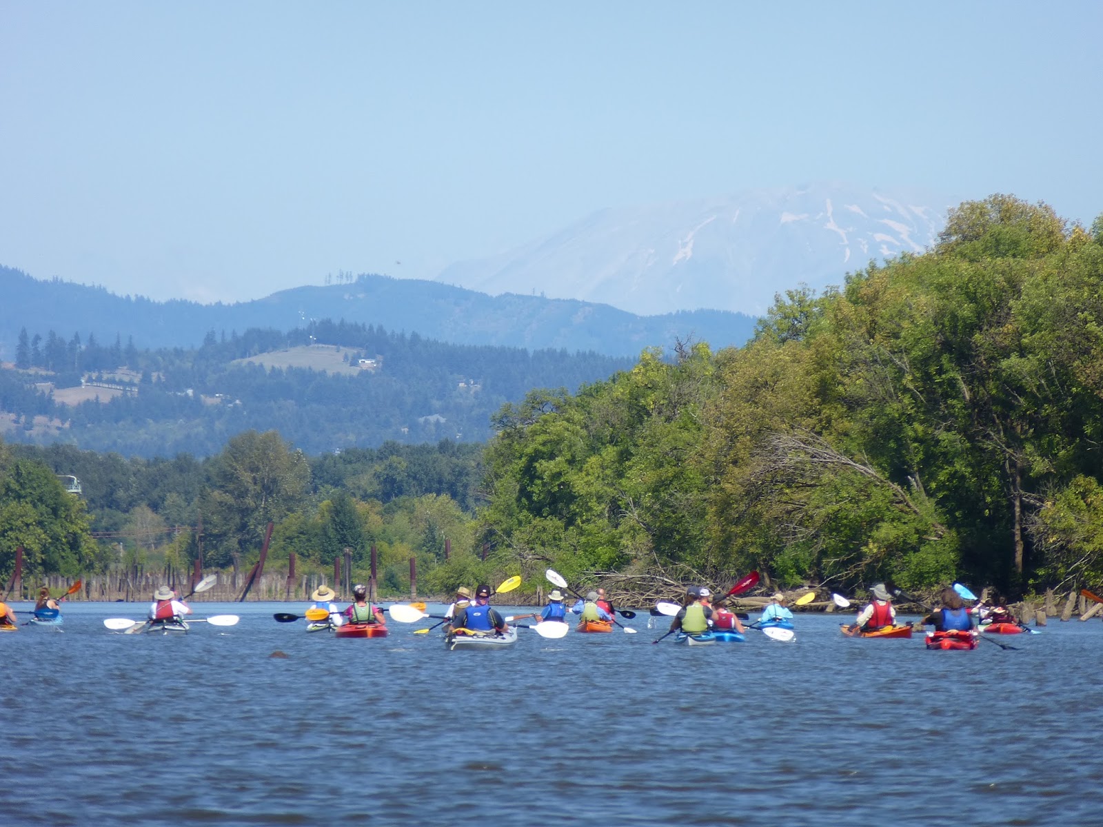
a hot sun, a blue sky, and very little wind. Mt. Saint Helens was
visible through the haze and we just paddled straight for her. The
group didn't move very fast, lots of people taking pictures, lots of
others new to their boats and trying to figure out how to go in a
straight line, but people were patient and we stopped pretty often to
allow people to bunch up again (and for me to dip my boat under and
cool down).


 |
| Goslings |
 |
| Mother Goose |
We had a very big pause at the end of
the bay, where it meets up with the Multnomah Channel. This was the
first place where we were hitting big water. We wanted to get the
group together here to cross the channel quickly and as a group so
that any large vessels coming through would see us and so we would
block the channel for as little time as possible.

The Multnomah Channel is officially a
channel of the Columbia river, but it breaks off from the Willamette
just before the Willamette joins with the Columbia, so I think of it
as sort a side channel to the Columbia. In between the Multnomah and
Columbia is Sauvie Island. Most of Sauvie is farmland (you can see
lots of cows when you paddle the little creeks in the interior) but a
lot of the west end is park or forest land and often frequented by
duck hunters in season. So don't quack.

Once bunched, we got up our courage,
and Bill started across the channel. I joined him and we quickly
had all 50 of us paddling madly across. A 40 or 50 foot cabin
cruiser had just passed by and it made a nice wake to crash through
and then try to surf. I have noticed that my Eddyline Journey has a
much lower bow that many other sea kayaks. So where the other boats
might broach over a wave, I often get it breaking right over the bow.
And when surfing, my bow often gets pushed under more than I think is
quite right. All of these are excellent reason for wearing that spray
skirt.
On the other side of the channel, we
are up against Sauvie. Lots of old abandoned (or at least not
currently used) shipping facilities in this area; in various stages
of decay. The newest structures look like they could have been used
just last week, well, except for the osprey nests in the loading
towers. They have conveyor belts and large ship loading faucets. They
look like they are devices for loading some sort of powder substance.
I was thinking wheat or sand. The problem is that this area used to
be all about lumber and logs. So perhaps it was wood dust. At any
rate, there have not been any large vessels tied up there for many
years. Perhaps since all of the trees were cut down. At other places
along the channel are much older setups. Lines of piers long decayed
to stumps. Each stump is now a little planter with it's own little
eco-system. My partner and I find this one place that appears to be a
set of ramps for hauling up flat bottom boats. Perhaps a building or
repair ramp. It is out on a place on the island where there is some
rock (instead of mud). A place that may be above ground even in a
flood (back before the Dams were made).
 |
| What was this? |
The water is cleaner out here than in
the bay. I requested a bow rescue from my partner. We are getting
pretty good at this now. I flipped over and stayed in the boat. Slap
the bottom of my boat 3 times, requesting a rescue, and then wait
patiently (upside down) until she hits me with her bow and I can grab
hold and rotate myself back upright. She had me do this the first
night I met her. It was a pool practice and she showed me how to come
to her aid so she could self rescue. I was very impressed. That was what
made me put her on my list of interesting people that I wanted to
hang out with. See what adequate safety drills can lead to?
A mile down the channel and we come to
the confluence of the Multnomah and the Columbia proper. There is a
large section of stumps down there. I don't know if they used to be a
dock, a mini stump city or what. Perhaps a Salmon catching and prep
area. Whatever, there is a pretty large section of telephone pole
size logs sticking up out of the sand. You go can around them or
weave through them, but either way you have to head upstream to get
to the beach by the lighthouse.

I don't actually know if it is still
a lighthouse, but it certainly used to be. Let me check the magic of
the internet for you: Ok, it is actually called the Warrior
Rock lighthouse. It still works and is one of two lighthouses in
Oregon that is not on the coast. You can get to it via a 3 mile hike
along the coast, or you can just paddle right up to it like we almost
did.
 |
| The Beach Below the Lighthouse |
50 kayaks on the beach. Pretty cool
looking. Such color. We all sat on the sand in the sun and enjoyed
the afternoon. I had just finished my sandwich when my friend Bill
brought someone over that had a science question for me. It seems
that she had one of those clip-on sun-glasses where the clip is
magnetic. When she dipped it in the sand (I am assuming the first
time was by accident) all of these little metal filings were
magnetized to it. She wanted to know what they were (and Bill knew I
was an EE so naturally I know everything about sand). Hey. This one I
knew at least the obvious part of the answer. Must be Iron !! Iron is
the only common mineral that is magnetic. But the iron was
EVERYWHERE. Must be a significant part of the content of the beach!!
Now, why was that? Was it a natural occurrence, or was it the
aftermath of the shipping and construction in the area. Maybe a WWII
submarine sank at this very spot....

 |
| see the magnetic. The black stripes, the sand.... oh,.... never mind |
Ok, my friends at work say “Duh, Jon.
Magnetic sand beaches are everywhere. Iron is like the 2nd
most common mineral on earth.” Next to (wait for it) SAND !! (well,
silicon). So, there you have it. Next time I go kayaking I am taking
a big magnet and a baggy. I will be RICH I tell you, Rich !!
Julie likes to have club contests. This
time the contest was “Who can stand up in their boat?!”. Would I
play? Of course I would play. I can fall out of my boat as good as
the next guy. 5 or 6 of us paddled out 10 feet offshore in like 5
feet of muddy water and gave it a shot. The deck was a little
stacked, Julie does this all of the time. So she stands up. The
secret is to get up on your deck with your legs out to either side.
OK. I did that. Never did that before, but I did that. Then get your
feet on the bottom. (I think you are supposed to put your feet ON
YOUR SEAT. I missed that part) and then.... well, just stand up. This
is where I lose it. With my feet on the bottom, I can't get my body
over my feet to stand before I lose my balance and dump into the
water. Oh well. I turned on my nifty little water pump and tried some
wet entries and such. Those didn't work either. AND I lost my water
pipe. Donated to the Columbia. It was good wet fun, though. The river
water was very refreshing.
 |
| Julie Stands up |
 |
| jon Stands up |
 |
| Bill stands up |
Afterwards a club member had come over
on a SUP and I got to try that. It was hard as hell and I hated it.
Really. I was on for like 60 seconds and my thighs were BURNING. So I
guess it is really good exercise until you figure it out.
 |
| Well, I look cool, but I am NOT HAPPY. |
Oh OH, the sun is starting to go behind
the trees. The beach goes suddenly cold. Time to get going. We got
ourselves packed back up and followed the thundering herd back down
the Columbia and back up the channel.


This time we came down on the South
side of the channel where we could get in amongst some more of those
pilings. These had a lot of plants on them and I wanted to take some
pictures. My partner doesn't like going in there but she is always
game for a challenge. So I have some pictures of me in there. Had
some waves come through while we were in the midst and I thought I
was going to get capsized up against a piling. But then I realized
that I could just put out my hand and steady myself on one. Another
genius insight.


Man we were tired when we got back to
the dock. Lug the boats back to the car, drive home, and collapse. A
good adventure.
Good story. This is a paddle that I'm wanting to do. Two questions: Do you know the distance you paddled? Was the tide a factor?
ReplyDeleteAbout 8 miles.
ReplyDelete