Devil's Rest (The Back Way)
This is a special hike that is not on
any of the maps I have found. A fellow hiker told me about it one day
and after a little searching I found it and now try to do it a couple
times a year.
You start out at Multnomah Fall. Yes,
the place where all of the tourists go. If you are going on a nice
day like today was (And Easter Sunday to boot) you may have a parking
problem unless you get there good and early. I have a somewhat secret
parking place I like to use (or at least try). Instead of parking in
the big main highway lot on 84, I enter onto the old historic highway
at the turn off right after Rooster Rock, then drive down toward
Multnomah. I look for parking at Wakeenah and Multnomah lots, but I
never find any, but right after the bridge over Multnomah creek,
there is a large secondary lot and much of it is unpaved and there is
usually some parking there. That is what worked for me today.


Lots of people out today. Lots of
families coming out after church. Lots of young women who have been
waiting all winter to go out in public wearing as little as they can
get away with. Lots of young men waiting all winter to see them do
that. Sigh.
I had packed a medium heavy pack, with
my stove and mixings for Easter Dinner, and I set out to make my way
to Devil's rest (or at least close to it).
The first mile of this hike is the
hardest. It is also the mile filled with tourists. So if you are
slugging it a bit, at least you get to people watch. I also take
satisfaction in that I can now climb this damn hill with a loaded
pack and be doing pretty good (of course, the youngsters in flip
flops carrying children are doing better....).
Never been to Multnomah Falls? Oh, you
gotta go. It is like 30 minutes east of Portland on I84 and it is one
of the most beautiful (and high) falls you will see. And the
surrounding cliffs (and the Gorge of the Columbia River) are nothing
to sneeze at either. So even if you don't want a big hike, head on
there one day. Bring a camera. Bring the family. Park in the I84 lot
and take the walkway under the highway and enjoy the view. On a hot
summer day, hanging out at the bridge over the lower falls would be
pretty sweet.


So, the first mile. 9 (or perhaps 10)
switch backs. Around 1.4 miles, 800 feet. This is a very well
maintained and paved trail. Plenty of places to rest. Lots of good
views. Lots of people. Lots of dogs. And during the summer, lots of
poison Oak (so stay on the sidewalk). When I was first starting into
this hiking thing, I did a lot of resting. Now I do 10 or 20 seconds
at each switch back and just power my way up.
I remember the first time I did this
ascent. I am not sure why, but I thought that when I got to the top
there would be this big flat plane with the river running toward (and
then over) the cliff. But that isn't how it is at all, when you get
to the top (at switchback 9) you enter into a secluded river valley.
A miniature gorge. With very tall and steep sides of its own and with
lots of waterfalls and rapids of its own. This is a very wonderful
area. There is a kodak picture moment about every hundred yards and
you really need to spend some time JUST LOOKING.
You also need to spend some time
watching your step. This trail was blasted out of the canyon wall
(like Eagle Creek) and there are lots of sheer drops and some very
rough and ankle threatening sections. Also, there is a lot of water
dripping across the trails, so things can get slippery. (Oh, in the
winter there is ICE that has turned me back a couple of times). Most
people just runs right across it, laughing as they go. Show offs. If
you have one bad knee and a sprained ankle (like me) then use your
trekking poles and go careful. And stop and take a lot of
photographs!


At about the 2 mile mark, the trail
splits. To the right takes you on the my normal Multnomah, Wakenah
loop. To the left is the trail to Larch Mountain (and, the Majestic
Larch). Today, we go left.
Right away we hit this section that had
some storm damage about 2 years ago. Lots of HUGE trees are down. The
have fallen from above the trail and down across the trail and then
splintered as they hit THEY OTHER SIDE of the canyon. Pretty cool.
The trail has been cleared, but the trees remain. (do I have
pictures?). Pretty quick we hit a metal foot bridge across the river.
It too was hit by one of these falling trees and got a big bend. It
was closed for a while, but now it is open with a warning to only
have one person on the bridge at a time. See, this way when it
collapses only one person gets killed.
This section of the trail is just so
redundant. Just one more incredible fall or rapid after another.
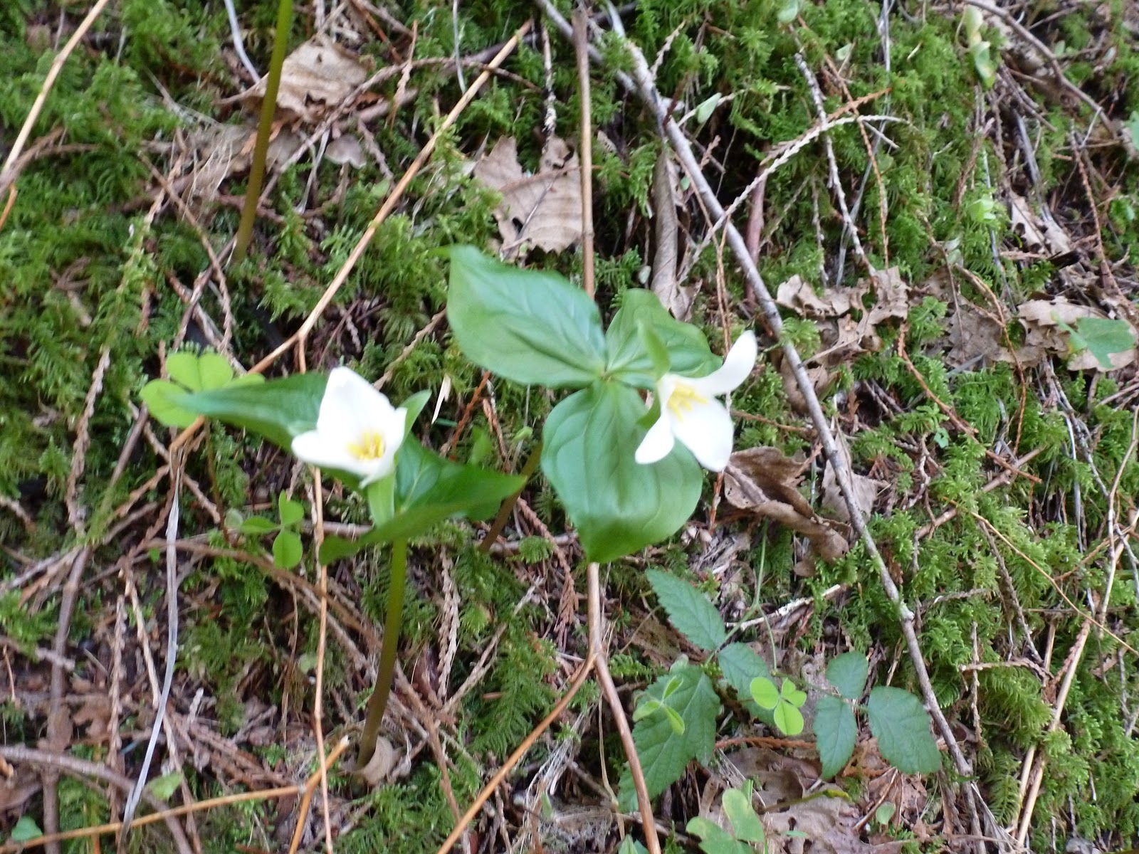
Yawn. On this trip, though, there was some Trillium lighting up the
day. A gift on Easter! Better than searching for Easter Eggs.


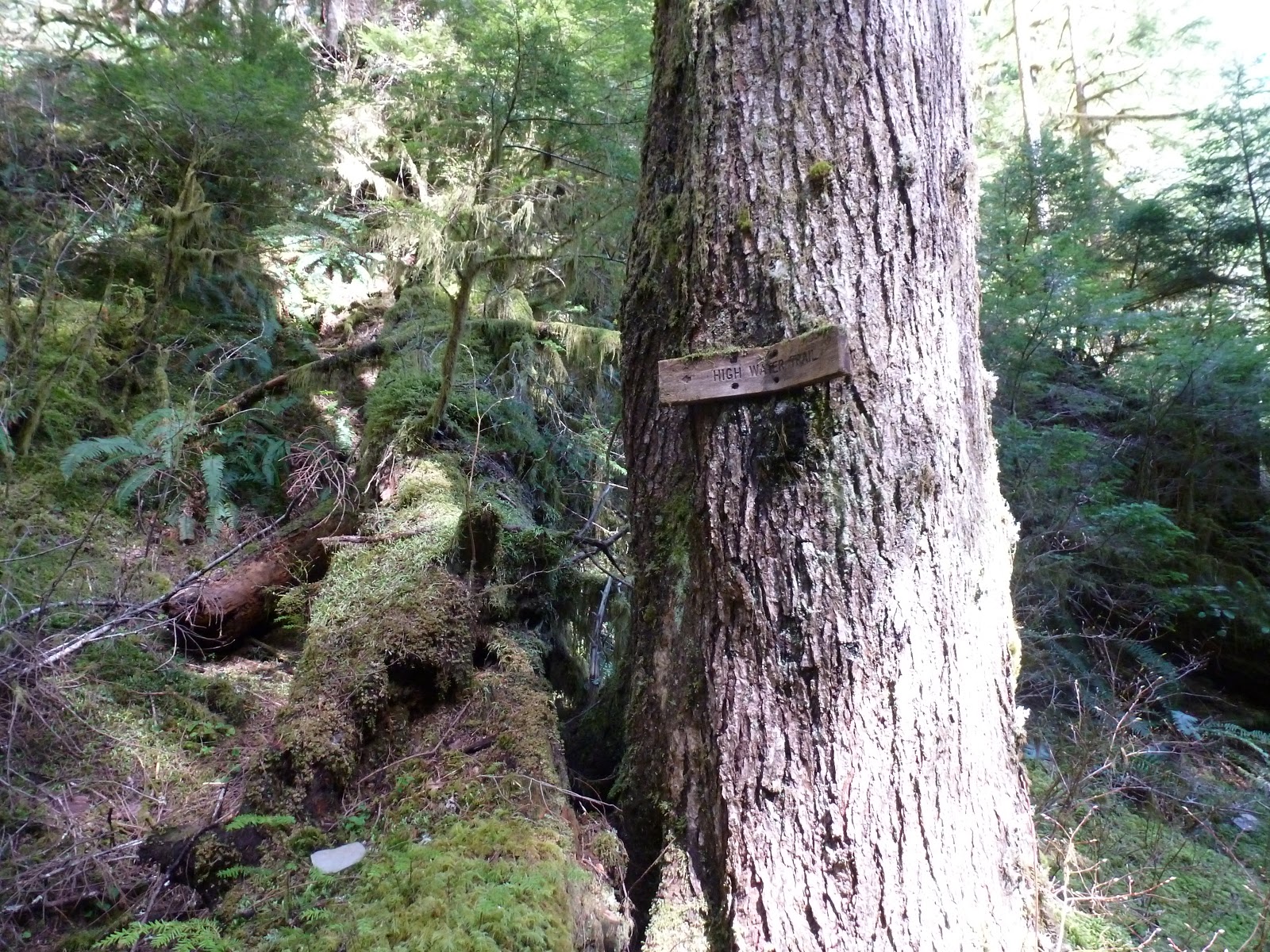

At one point on the trail you will hit
a sign that says “High Water Trail”. That is the way you go if
the river is so high that the “low water trail” is.... welll...
underwater. Today (and every other time I have tried this) the low
water way was fine. It is also only about 100 yards, so taking the
high road isn't that big of a deal.


Just a bit after this section you will
it a dirt road. Bunches of signs telling you things. But none of them
tell you what the road is. That road is sort of a secret (I think).
It is called the Multnomah Basin road and it runs from someplace I
haven't found yet up to the Skamania Lodge. This is a private lodge
of the Portland Hiking Club (or perhaps the Portland Adventurers
Society). I will look it up and forget to post it later. Anyway,
Thanks guys for maintaining that bridge! (though they need to do more
maintaining because I don' think they can get a car across right now.
Perhaps they need to charge more dues).
Anyway, we are turning right at the
road and we are going to follow that road all the way to Devil's Rest
(sort of). First we cross the suspiciously broken looking bridge (it
has footpath stuff set up but has warnings for vehicles), then we
start to climb up out of the canyon. This isn't a steep ascent, but
it does go on for at least a mile. Still, it is a car road and easy
to follow. We eventually come to a locked control gate, there is a
little path around it and then we are up on the top of the Plateau.
Half a mile and we will come to a little “parking” area and a
sign on the tree indicating park lands and a hiking trail. Turn Right
and in a 100 yards you will intersect with the Devil's rest trail.


This is the spot I like to stop and
make camp for lunch. It is a protected area, there are good spots for
setting up a shelter (don't need one today) and it is on the trail so
you can say high to fellow hikers on their way to Devil's rest. (oh,
and every other group will ask you how far it is, so make sure and
have some witty answers ready).
I like to call this spot Devil's rest.
It isn't really, but the real devil's rest is just a bunch of rocks
about ¾ of a mile further on. Yeah, it is a little higher up, but it
is completely surrounded by trees and there just isn't any view
there.
So stop here. Take a load off. Make
some Tea. Eat your lunch. There is a nice view of the columbia and
the sun is shining. There is even the sound of a little waterfall
just over that cliff in front of you. I like it.
After lunch you have some choices. You
can go straight down and back to the car. About 2 hours from here. Or
you can continue on to Devil's Rest and then on West on a
non-official trail called the Foxglove Trail which will take you
around to Wahkeena springs, down Wahkeena valley, and so back to the
car. We are a little short on time today (I have some homework) so we
are going to go home the short way, but what the hell, lets go some
of the way toward Devil's rest and visit this one really great view
point. It isn't hard to find. Just head toward devil's rest and there
is this one point where the trail will turn and start doing some
switchbacks upward. Just before that, there is a survey marker and
just after the survey marker there is a point where the trail
branches (though the right branch isn't real visible). That right
brach goes through some trees and in 100feet hits a cliff and some
nice rocks and great view of the Columbia and Mt. Saint Helens and
Mt. Adams (both with a lot of snow this time of year). Nice.


Ok, enough. Grab my trekking poles and
head for the car. It is all down hill from here. I follow the devil's
rest trail down to the Multnomah trail and follow the ridge back
around to the crossroads we have already seen one this morning. Now
we are back on Multnomah creek and retracing our steps.
A little different this time, however,
because the sun is going down and it is setting in such a way that it
is really lighting up the canyon. So Green !! And so many people out
today. So many Tatoos ! (oh, I like that one!)


I don't know what it is about me. The
close I wear? My Age? My general appearance of stunning competence?
Or perhaps the big backpack, but I have LOTs of people stop me and
ask for information or directions. I had one guy say, “Excuse me
but I have a question”. It is like I am a ranger or something. Of
course, the really funny thing is that I always know the answer.
Perhaps it is my mutant ability.
Hey, it was a great hike today. 10.1
miles !! Thanks for coming along.
Cheers !!
What a great day for a hike! Thanks for sharing
ReplyDeleteTHanks for leaving a comment. This makes my Day! (ON these blogs you never know if anyone really reads them).
DeleteCHeers,
Jon
Reading this all the way from Guernsey,Channel Islands. (a tiny island in the English Channel) I would love to visit Multnomah Falls one day and now reading your blog has inspired me all the more. I like your style of writing and look forward to reading more!
ReplyDeleteHey Trish, thanks for reading my blog and leaving a comment. I hope you have a chance to visit the American Pacific Northwest sometime. Lots of nice waterfalls here.
DeleteThis comment has been removed by the author.
ReplyDelete