Silver Falls
This is one of the 3 quintessential Oregon Hikes. And by far the most accessible. So, if you have pretty much anyone in your party, And want to see some world class waterfalls without flying to South America, this is it for you.This unique geographic feature is about 1.5 hours south of Portland. Just far enough that it isn't completely overrun on a nice sunny day (well, if you get there early). The hike that I did with the Intel Hiking club is about a 6 mile loop that goes down one river branch, up another, and then comes back to the parking lot. There are unique and beautiful things to see on all 3 legs.
So.
A map. Lets see if I can magically make a link into the Matrix:
Silver Falls Trail map
Oh, that was fun.
Anyway, There a couple of places to start this hike, but the surest place is the large parking lot at the South Falls.
The most tragic thing about this hike is that the most AWESOME INCREDIBLE and BEAUTIFUL waterfall you have probably ever seen, is like 5 minutes walk from the parking lot. Very unexpected. Very Unique. But must too easy to get to. Makes it a little cheap.
But oh, it is wonderful.
 |
| Upper South Falls. See the people behind it? |

Because we are at a big fall, and we are going to more downstream, we start out going all down hill. Don't get too comfortable with that, we have to get back to the car eventually. But all in all we are only talking about a few hundred feet give and take. This has nothing on Dog Mountain.
The Intel Hiking club always goes the weekend of Mother's Day. That is the weekend that people walk around with numbers on their chest in nearby Silverton (I have no idea) and there is a wildflower plant exhibit at the lodge at South Falls. A good day to drop in and try to memorize some of the flowers before you head out. Personally, I like dropping in again afterwards and trying to identify the flowers that I found that I didn't remember the names.
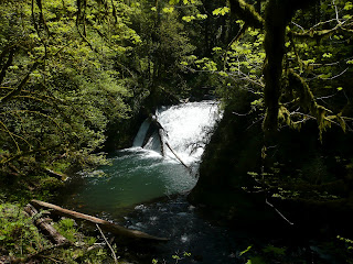
I don't think I want to walk you through all 10 falls (and probably at least that many odd streams falling into the gorge). Instead, let me give you a general feeling.
We are starting out at the top of a lava flow from some ten thousands of years ago. The two branches of the river we are going to follow have been cutting their way back since then. That is how these steep falls get built. Over the centuries, the falls are cutting their way backward into the lava flow.
 |
| Lower South Falls. |
 |
| Behind Lower South Falls. Ain't that cool? |
So you have a large cliff that is marching backwards with the years. We are just hiking the current face of these rivers. Lets make a note in our iPhones to come back in a few mellenia to see how things have changed. If you start at Upper South Falls (and why wouldn't you, it is by the big parking lot) then you hike down the south fork river and then turn and hike up the north for river. Lots of Falls ever half mile or so, and each one is just a little different.
 |
| Western Corydalis |

 |
| double falls |
 |
| Fairy Bell |
Lots of flower along the way....
 |
| Fairy Bell and Bleeding Heart (and some Forest Violet, in yellow) |

 |
| Yellow Fawn Lily |
 |
| Calypso Orchid. |

No comments:
Post a Comment