Cozumel Diving Vacation: Part 1
 |
| On Vacation |
 |
| The Day Before Vacation |
At Playa Del Carmen
Sitting on the roof of the Hotel 52 with a cafe and pleasant company.
We have been in Mexico now for 2 nights. We flew in late Saturday to the Cancun Airport, caught a easy, quick shuttle to our hotel, and have just been exploring the local town (5th Avenue of Playa Del Carmen) and enjoying the good food and tourist traps.
 |
| The court of the Hotel 52 |
I am going to have to do some research to figure out Playa Del Carmen. The place we are staying is pretty nice, but it is of a strange construction. Everything here is cinder block cement strutures. Rebarb and cinderblock going up to a max of about 5 floors. I am guessing that is about the weight limit for cinderblock. The construction is all done in a way that is very Human worker intensive. I don't see or hear any machines going, though there are a few buildings under construction in the area. Lots of hammers and hand saw noises. Lots of pulleys and ropes and guys pulling on them. Lots of corregated tin overhangs on the sidewalks to keep the rock from falling on the touristas. Our hotel is on Calle 52, at the North end of the 5th Ave Tourist strip. 5th Ave is, for the most part, a pedistrian only street lined with shops and bars and reastaurants and such. Big tourist stuff shops selling mexican beach shirts and shot glasses made in China. Closer to the center of town you hit an actual shopping mall and big American names, like Nike and Starbucks.
 |
| Up on the Roof is the hang-out place. Secured. |
 |
| View from the Roof. There is an infinity pool up here too. But it was small and in high demand |
Out where we are, the 5th ave has the same general construction. It is lined with nice street lights and walkways, and the road is a sort of cement small stone road. It is still mainly for pedestrians, but cars can (and occasionally do) drive it. One lane south bound only. Not sure how far the 5th avenue pedestrian way goes. You can tell they put a lot of money into it 10 or 20 years ago. I think the plan was that the rich area would extend for a mile or two past where it actually seems to have stopped. Or at least slowed. Lots of signs on partially built (and perhaps abandoned) buildings advertising the wonders of owning a condo on the playa. Many being sold for $100,000 American. That doesn't sound like too much for a nice condo, but I think that is price for what is essentially a concrete shell. You have to provide all of the innards. In some cases (see the pictures) that might include a floor.
 |
| The Paritially constructed place next to Hotel 52. No work going on here |
 |
| A place across the way. From the window of our hotel room |
And you could be buying a place downstairs while the guys are still building up. Across the street from our Hotel is a place where they have finished a couple of units going up, but the attached building and around the corner is still under construction. It has the look of construction that goes on for a long long time. I guess I need to come back in a couple of years and check out the progress.
 |
| Luxury Investments. You must be a visionary |
 |
| This is a finished unit for sale (I think) there is a big hole down there. For you basement. You have to provide the furniture and the floors. There was a complete unit two doors down. The sales office and a restaurant. |
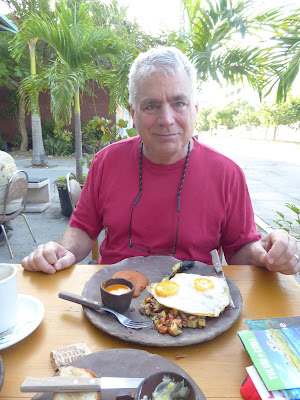 |
| This was a yummy Breakfast |
Great Restaurants here. I have already had 5 much too wonderful meals. For dinner last night we went to a place that I believe was called Puerto. I had gordonitas, which were little corn tortilla pockets stuffed with seafood yumminess. Octopus in one. Shrimp in another. I believe it was some white fish in the third. With very good sauces. Hmmm. My touring partners had shrimp and grilled fish (which our waiter believed was grouper (in English)). When we sat down the guy behind us leaned over and told us that this was the right place. He was from Iceland and he and his family had been coming to this restaurant every year for 3 or 4 years already. He was very happy that we were there. I found out later that the margaritas were pretty strong. Perhaps that was the explanation for his chattiness. Or perhaps that is just the way of Icelanders.
So we are walking down 5th on our first night here. Just getting a feel for the place and looking for a place for dinner, when this guy comes up to us, all smiling. He says "Hey Amigos, good to see you again. Don't you recognize me? It is me, Carlos, your waiter from the Hotel. I work here during the day time. Don't you recognize me?"
We, of course, told him that he was mistaken and we had just gotten into town and had not seen him at the hotel. He insisted he knew us. At this point I was getting a little wary, and we walking away.
 |
| 5th Avenue. Can you find Señor Frog? |
The next day, the same guy did the same thing in the same place. My parter said something like "Hey Carlos, you tried this on us yesterday." He was still pretty insistent. I was going to think that it was just that guy but we walked further into town and a different guy gave us the exact same line. "Hey, don't you remember me, Carlos from the Sands!!". What is strange is that his name was still Carlos and I am pretty sure it was from the same restaurant. This time he was targetting my partner. She laughed at him and he got a bit put off. "Hey, don't laugh at me".
"Sorry," said my partner, "But there was another guy not 5 minutes ago who tried the same line on me."
He cheered up then, "Oh, Ok. Have a nice day". And we were off.
In general we learned that it isn't a good practice to say hello to street vendors that say hello to you. It is just an opening for them to make a sales pitch to you and you really don't have the time to listen to every pitch as you walk down the Avenue.
(Editor's note): It's really just deciding who to talk with, and what you are shopping for. You don't want to chat, but if you are looking for something, and like to bargain, street shopping in Mexico can be fun.
 |
| These signs follow us everywhere |
 |
| They had this weird storm a year or so ago that floated in a bunch of sea weed (saragosum). It is still there, even though they are running front end loaders to try and cart it away. |
There were lots of people about. Many of them thin, handsome non-Mexicans. We think they were mainly Europeans. We talked to the one man from Iceland and another couple from Holland. The Dutch couple we met when we were all stranded together in front of a Skin Treatment Salon during a strong but short downpour.
Speaking of Skin treatments, Would you like to sit in the front of the shop by the street and dangle your feet in a tank of water and let little fish eat the dead skin off of your feet and legs? Doesn't that sound great? It must have been a new thing a couple of years ago, but now little tank setups were everywhere in front of many different shops.
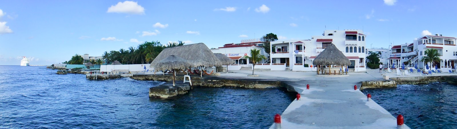
Scuba Club Cozumel
 |
| Our Hotel from the boat dock. Hammock shack on the left. Dive shop up the path on the right. |
We are going to be spending seven nights at a resort on Cozumel called Scuba Club Cozumel. This is advertised as the first club designed by SCUBA people for SCUBA people. It is a mostly all inclusive resort, but not a big or fancy one. What SCUBA special things does it boast?
- Rooms that are pretty water proof, no rugs, lots of drains and tile.
- A significant drying rack on the porch of each room (for wet suit and other wet gear)
- Large, freshwater rinse tanks positioned on beach level.
- Large lockers near the rinse tanks (these are lockers big enough to put a couple of SCUBA tanks into should you want to do so.
- On site compressor and dive shop (for gear rental)
- Free lead and belt (unless you lose them).
- Ladders and stairs into to the sea built to accommodate people in lots of gear.
- A big dock that can accommodate 2 dive boats at a time for fast loading of divers.
It also boasts a small pool and a row of hammocks, for people that are either not diving or are relaxing afterward.

We were going to be there for seven days. Five days we would be doing boat diving. One day we had off for other adventure and one day (at the end) you NEED to have off because you can't travel on the same day that you dive. Actually, you can't FLY on the same day that you dive. Why can't you fly? Because the risk of getting the bends (or decompression sickness) changes dramatically if you change your ambient pressure. So you need to hang out at sea level until all of the saturated nitrogen that you built up at 80 feet under the sea is out of your system. I once look at my Altimeter on my watch when I was flying. The pressure inside that plane was the same as being at 6000 feet.
Here is the schedule on a typical Diving day. Coffee is guaranteed by 6:30, but every morning it was available by 6:00. It is still dark this time of year at 6:00, but we were there during a full moon and it was nice to go out to the hammocks on the beach and watch the moon set. At 7:00 a substantial (though cafeteria style) breakfast was served. There were always pancakes and french toast and a few different kinds of eggs and lots of fruit. We usually finished breakfast by 7:30 and then went to get our gear together.
The previous day, if you were going diving, you signed up on the sign-up list for diving. Around 7:45, the actual divers list would be posted and you could see what boat you were on, who your dive master was, and what other divers you were going with. For our first couple of days we were on the Dive Cat (see below) with dive master Tony.
 |
| Dive Board |
The Dive shop opens at 7:00. But don't try to get anything from them at that time. They are spending all of their efforts moving all of the necessary equipment the 200 feet from the shop down the ramp to the dock. This mainly means moving SCUBA tanks. On a typical day we were there, there were about 50 divers. Two tanks per person (plus a couple of extras and tanks for the dive masters) is like 120 tanks. An Aluminum 80 (The standard recreational dive tank, an aluminum cylinder that holds 80 cubic feet of air at 3000 psi) weighs in at 35 lbs when full. That is over two tons of tanks to haul down to the dock with less than an hour to do it. So stay out of their way.
 |
| Loading Tanks |
The boats start to show up around 8:00. On a busy day there would be 4 or 5 boats. Two would dock immediately and start loading tanks from the dock to the boat. This is all manual work, no carts or cranes. It takes a few minutes. As soon as the tanks are loaded, the divers board their boats. Make sure you know the name of you boat. The names are all a little bit alike and a couple of times people got on the wrong boat (at least at first). They don't usually take role call, they just count heads and go. They are in a hurry because there are two more boats to load.
Our boat usually was sitting off shore and waiting her turn, so we didn't usually board until right around 8:30. Carry your gear onto the boat. This can be a bit tricky. You have this heavy (~20 lbs) weight belt to carry, plus fins, mask, BCD, regulator, wet suit, and your clothes. The easiest way to carry a weight belt it is to put it around you waist. But then, if you trip into the water, you are going right to the bottom. Which isn't that dangerous unless you bang you head on the dock on the way down, or rupture your ear drums from the quick descent while trying to release your weight belt.
During instruction, they tell you NEVER go near the water with your weight belt on unless you are also wearing a BC (Buoyancy Compensator) and a connected tank (to put air into the BC). I carried mine and handed it over to one of the staff before I stepped onto or off of the boat.
Once on board, one of the crew will take your BCD and place it on a tank (your first tank for the day). They will also strap it down and connect up the regulator and stuff if you let them, but it is sort of satisfying to do this yourself (along with all of the recommended safety checks). Put your weight belt at the base of the tank and put your fins near that. You mask and snorkel goes into a bucket of (what I think is fresh) water sitting near the Camera water bucket. Why do you put your mask into water? I am not real sure on this, but I think it is to get your mask to the temperature of the sea water (more or less) to help avoid fogging. Got everything done? Great! now go sit up on the bow in the sun and enjoy the day, because it is going to be an hour of cruising before we get to our first dive site.
This is some of the best part of the day. All sorts of stuff is going on in Cozumel. And since most of that stuff has to do with the Ocean, and most of the nice ocean is south of our resort, you get to see all of the fun and crazy stuff that the rich tourist are involved in. More about this later.
I enjoyed standing up in the front and watching the bright blue water slip by beneath the double prow. On a few occasions we had the excitement of stirring up some little flying fish. They were not much bigger than anchovies, but they would get surprised by the Dive Cat plowing over them and they would take to the air. They would jump up, pretty much on top of the water, with everything dry except this little rudder tail that would extend down into the water. They would extend their little fin-wings and then give a little accerating kick with that little fin and launch themselves into the air. Then they would glide, for at least twenty feet. But some stayed in the air for a few seconds and would glide 50 or 60 feet before collapsing their wings and dissapearing back into the depths.
Dive Cat
 |
| Dive Cat waits her turn |
Our boat for the first three days is called Dive Cat. I am guessing because it is used for diving and it is a Catamaran. But I could be off here. Judging by the names of all of the dive boats that I saw going by there seems to be a simple algorithm for naming a boat. First you start with the words SEA DIVE or REEF. Then you add some fun or descriptive word, like CAT GIRL or HORSE and you got it. So Dive Cat, Reef Cat, Reef Diver, Sea Horse. I saw one SEA DIVE. These are all work boats, don't you know. The fun boats, like the fancy sailing catamarans and such have more fanciful names. Like Triumph.
Utilitarian. That is was the Dive Cat is. Two Hulls with a platform on top (being a Catamaran and all) The deck is wide and flat. Captain's console in the center. Tank storage and entry in the stern. Places to hang out and more storage in the bow. Twin engines in the stern of each pontoon. A little room with a head downstairs in the port pontoon. The center part of the boat is covered to both sides with a seven foot high hardtop. There is a ladder and you can go up on the hardtop to take the sun or smoke a cigarette, but there is really nothing up there. No substantial rails or seats or anything like that, you are just up on the roof.
 |
| On the Cat |
 |
| Only the best people on the Cat |
Since all of these dive boats are work boats, they are not speeders. They get up and plane on their flat bottoms and move along at perhaps 15 knots. The Dive Cat may be a litttle faster than some of her single hull cousins. We did pass a few boats heading South. But we got passed by some others also.
The routine for diving from Scuba Club is to head South along the coast for about an Hour. Then stop (not anchor) and drop divers for the first dive. After diver recovery, head back North for half an hour or so, then stop and do the second dive. That leaves you just a short jaunt back to the dock after you finish your diving.
Drift Diving Cozumel
In Cosumel, on the West Coast, there is a prevailing ocean current running South to North. The current can vary in intensity, but it is always there. Normally the current is not faster than a diver can swim, but you sure couldn't fight it for long. This means that you would not be able to get back to or rondezvous with an anchored dive boat. And so you do drift diving. So, both you and your boat are constantly drifting with the current. I was a little...... worried? Concerned? Freaked Out? by this idea. I couldn't get any one of the divers around to tell me a drift story that didn't start "Man the current was bad out there when we went". And I just couldn't get an idea of what the terrain was like for the dive. In my imagination, we would be on a cliff wall that started at 50 foot deep and descended vertically down to 10,000 feet !!!! And we would have to maintain our depth exactly at 60 feet or we would surely die as we went whipping past the cliff wall at 37 MPH!!

Needless to say, reality was somewhat less alarming. On our first dive, we jumped in the water and then descended to a realatively flat plane at around 30 feet. There was some current. You could have swam against it if you were really of a mind to. But you didn't have to. In fact, you didn't have to swim much at all, other than to zig back and forth to see things. You just let the gentle current move you along to each new sight. And there were many sights to see. Lots of purple sponges and big corals and colorful fish. Then we came to a bunch of rocks, the depth dropped down 10 or 20 feet between the coral and grass strewn rocks and with 70 feet of visibility, it was pretty great. Sometimes you had to fight the current a bit to avoid getting pushed into a rock (or another diver) but it was not all that concerning. When we got to around 700PSI of air remaining, the dive master inflated a "safety sausage". This is plastic sausage balloon on a string teather. It is inflated manually (that is, you take out your regulator, put your lips to the nozzle and blow). It floats up to the surface to tell other boats that divers are surfacing. The Dive Master stays on the bottom with the other end of the tether (and the other divers) and you follow the line up (you can't hold on to it, it isn't that big of a float) and hang out at 15 feet and do your 3 minute safety stop. While you are doing that you can look around and see your fellow divers down on the bottom who use air more slowly than you. Count your 3 minutes, look cafefully around (oh look, I think I see our boat bobbing over there), and then go to the surface and inflate your BC so you stick up in the water and the boat can see you and come pick you up. Easy Peasy. Nobody died or nothin.