The Cove Palisades State Park is, in general, down close to the river. Down in the canyon. But there are a couple of parts of it, called "the Island" and "The Peninsula" that are up on the level of the top ancient lava flow.
The Island is strictly guarded area and is the plateau between the Deschutes and Crooked rivers with its tip at the historic confluence of those rivers (now dammed lakes). What makes it an "island" is the fact that the flat top of the plateau is seperate from the other parts of the high desert that are above the canyon. Turns out that the Platea is geologically different that the other high dessert flatlands and was created by an inter-valley lava flow. And no, I have no idea what that means. But it is lower.
The Peninsula also has The Deschutes and The Crooked on 2 sides of it, but its main side is connected to the rest of the high desert (you an drive there). The vegetation and terrain, however, are very similar to that of the Island and you can see down onto the Island from the viewpoints up on the Peninsula.
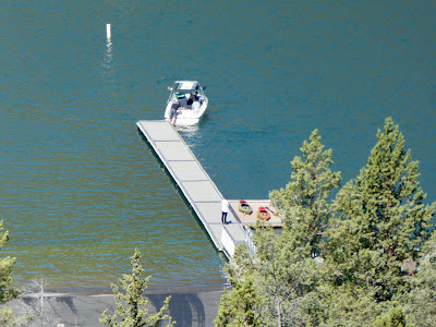
Today, myself and Rory the wonder dog, are going to climb that state park trail up the rim of the Peninsula from the Deschutes upper day use area and boat launch. We dropped Paige off at the boat launch for her to do a paddle with the OOPS club while Rory and I have a puppy/dad hiking date.

We are hiking the Tam-a-láu Trail. There seems to be some argument as to where this trail starts. There is a trailhead marked in the boat launch parking lot, but there really isn't any single car parking there (don't know if it matters). The real trailhead is over in the C loop of the Camping Area, but there is really no place to park there. I would recommend parking in the car parking for the upper Deschutes day use area and then follow the path (or road) the short ways to the camping area. You will see the trailhead sign. Of course, if you do start at the boat launch parking area you get to hike through a rather nice boulder field.
Today I am hiking with my friend, Rory the wonder Dog because my usual hiking partner is out kayaking with our OOPS friends. We just dropped her off at the boat ramp and then headed up the trail. The cove palisades A,B, and C camping loops are down in the valley below the Peninsula. The trail climbs from the canyon floor up through a lot of scree and boulders to eventually end up in a loop around the Peninsula.
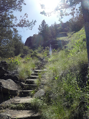
This is not a difficult trail to hike, though there are a couple of hairy places, especially if you have problems with heights. From the official trail start at the Loop C dog park, you climb over some rolling hills and then overlook a wide little valley strewn with large boulders that have come tumbling down from the rock face 800 feet above. Some medium sized trees and brush in this area. Also a number of switch backs with wooden steps built into some of the most steep places. These steps are the first hazard as the dirt fill around them is heavily eroded and the steps themselves are often to high for comfort (I had a bitch coming back down). But you wind your way up pretty quickly and then turn off what looks like a seasonal creek to head along the edge of the cliffs still below the top of the plateau. This time of year I am seeing many of the beautiful yellow balsamroot flowers.
 |
| Basalt Cross-section on the Rim across the river |
Now comes the area that is steep too on both sides and can be a bit of a slipping and falling danger. The trail is loose gravel. My puppy has no problems, however, and we go right up this section until we arrive at a little depression below the main plateau. This is our step to get up top. Just a couple of more short switchbacks. This little area must hold some of the local water because there is more vegetation here that up top. Keep an eye on your dog when you are out walking, this area has warnings for rattle snakes. She did pull me off at one time and I saw a snake that I pulled her off from. But on seeing it it was clearly not a rattler. It was a gopher snake or something like that, about 2 feet long. So we zigged back up the last little bit before the top and hiked past a nice tree overhanging the trail and making a perfect shady spot for lunch. We will come back here later toward the end of our hike. Much too early right now.
There were a number of people out hiking. A few groups doing the entire 6 or 7 mile loop. I didn't have time to go that far so Rory and I just headed clockwise around the loop to quickly get to the couple of over looks that had the best view of The Island.
The top of the plateau is very flat and looks like much of the high desert in the vicinity. Scrub pines and perhaps creosote bushes. Some little flowers. The trail had been very muddy in the last few weeks and there were so good deer tracks running through the now rock hard mud. This part of the hike, the loop around the top, is all close to the edge of the cliff, so you always have a view of something. The canyons and lake, the snow covered Cascade mountains, the surrounding high desert. It is a lovely place to visit.
We went about a half mile to the closest good outlook. From here we could see across the chasm that is where the A,B, and C loops are for the park. This is a wonderful view of "The Island" which is the plateau between the two rivers. This flat area is not readily accessible from anywhere and is a bit lower than where I am hiking as it was created by a different lava flow condition. If I understand the geology report correctly, the island was formed by lava flowing down the river valleys and then over between them. I really need to investigate this more.
On the way back down, Rory and I stopped under a shady bush for some lunch. She didn't see it, but there was a snake just like that previous snake (perhaps the same one) just lazing out on one side of the trail. We sat down about 10 foot away from it for out lunch and some water and that snake didn't move the entire time. I have heard that snakes have no scent, and that would explain why Rory never noticed it.
Back down we go. Those wood plank steps proved to be much harder for my bad knees going down then they were coming up but I guess that is the way of old knees. Rory didn't seem to notice them.


